Boyd, Montana
| Boyd, Montana | |
|---|---|
| Census-designated place | |
 Boyd  Boyd | |
| Coordinates: 45°27′27″N 109°03′57″W / 45.45750°N 109.06583°WCoordinates: 45°27′27″N 109°03′57″W / 45.45750°N 109.06583°W | |
| Country | United States |
| State | Montana |
| County | Carbon |
| Area[1] | |
| • Total | 0.22 sq mi (0.58 km2) |
| • Land | 0.22 sq mi (0.58 km2) |
| • Water | 0 sq mi (0 km2) |
| Elevation | 4,037 ft (1,230 m) |
| Population (2010)[2] | |
| • Total | 35 |
| • Density | 156/sq mi (60.4/km2) |
| Time zone | Mountain (MST) (UTC-7) |
| • Summer (DST) | MDT (UTC-6) |
| ZIP code | 59013 |
| Area code(s) | 406 |
| GNIS feature ID | 802051[3] |
Boyd is a census-designated place and unincorporated community in Carbon County, Montana, United States. As of the 2010 census it had a population of 35.[1] Boyd was a stop on the Northern Pacific Railway en route to Red Lodge. A post office was first established at Boyd on March 12, 1909 with Roland N. Doughty as the town's first postmaster. Since December 3, 1965, the office has operated as a rural station or a CPO of Roberts with the ZIP code of 59013.
References
- 1 2 "Geographic Identifiers: 2010 Demographic Profile Data (G001): Boyd CDP, Montana". U.S. Census Bureau, American Factfinder. Retrieved October 8, 2014.
- ↑ "American FactFinder". United States Census Bureau. Archived from the original on 2013-09-11. Retrieved 2011-05-14.
- ↑ U.S. Geological Survey Geographic Names Information System: Boyd, Montana
Municipalities and communities of Carbon County, Montana, United States | ||
|---|---|---|
| City | 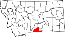 | |
| Towns | ||
| CDPs | ||
| Other unincorporated communities | ||
This article is issued from Wikipedia - version of the 11/6/2016. The text is available under the Creative Commons Attribution/Share Alike but additional terms may apply for the media files.