Bratunac
| Bratunac Братунац | ||
|---|---|---|
| ||
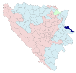 Location of Bratunac within Bosnia and Herzegovina | ||
| Coordinates: 44°11′N 19°20′E / 44.183°N 19.333°ECoordinates: 44°11′N 19°20′E / 44.183°N 19.333°E | ||
| Country |
| |
| Entity |
| |
| Government | ||
| • Mayor | Ivana Babić (SDS)[1] | |
| Area | ||
| • Total | 293.49 km2 (113.32 sq mi) | |
| Population (2013 census) | ||
| • Total | 22,473 | |
| • Density | 73.7/km2 (191/sq mi) | |
| Time zone | CET (UTC+1) | |
| • Summer (DST) | CEST (UTC+2) | |
| Area code(s) | 56 | |
| Website |
www | |
Bratunac (Cyrillic: Братунац) is a town and municipality located in eastern Bosnia and Herzegovina. The easternmost point of Bosnia and Herzegovina is located in the municipality of Bratunac which lies in the entity Republika Srpska.
History
Early history
In 1381, the name Bratunac is mentioned for the first time because of the direct road through Bratunac from Bosnia and Herzegovina to Serbia. At the time, Bratunac was composed of five houses and a population of roughly 30 people. In 1927, Bratunac became a municipality for the first time.
Demographics
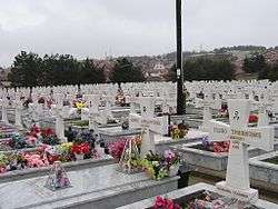
A Serbian cemetery of the civil victims of the war.
1948
In 1948 Bratunac had a population of 5,033. (Source: Columbia-Lippincott Gazetteer)
1971
26,513 total
- 13,428 Bosniaks (50.64%)
- 12,820 Serbs (48.35%)
- 50 Croats (0.18%)
- 15 Yugoslavs (0.05%)
- 200 others (0.78%)
1991
In the 1991 Yugoslav census, there were 33,375 inhabitants of Bratunac municipality, made up of:
- 21,564 Bosniaks (64.2%)
- 11,479 Serbs (34.2%)
- 41 Croats (0.1%)
- 491 others (1.5%)
Settlements
- Abdulići
- Banjevići
- Biljača
- Bjelovac
- Blječeva
- Boljevići
- Brana Bačići
- Bratunac
- Dubravice
- Fakovići
- Glogova
- Hranča
- Hrnčići
- Jagodnja
- Jaketići
- Jelah
- Ježeštica
- Joševa
- Konjevići
- Krasanovići
- Kravica
- Krke
- Lipenovići
- Loznica
- Magašići
- Mihaljevići
- Mlečva
- Mratinci
- Oćenovići
- Opravdići
- Pirići
- Pobrđe
- Pobuđe
- Podčauš
- Polom
- Rakovac
- Repovac
- Sikirić
- Slapašnica
- Stanatovići
- Suha
- Šiljkovići
- Svilile
- Tegare
- Urkovići
- Vitkovići
- Voljavica
- Vraneševići
- Zagoni
- Zalužje
- Zapolje
- Žlijebac
See also
- Municipalities of Republika Srpska
- Konjević Polje
- Bratunac Massacre
- Veljaci Bratunac
References
External links
| Wikimedia Commons has media related to Bratunac. |
This article is issued from Wikipedia - version of the 10/12/2016. The text is available under the Creative Commons Attribution/Share Alike but additional terms may apply for the media files.