Čapljina
| Čapljina Чапљина | |||
|---|---|---|---|
| Municipality and town | |||
 | |||
| |||
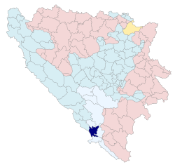 Location of Čapljina in Bosnia and Herzegovina | |||
 Čapljina Location of Čapljina in Bosnia and Herzegovina | |||
| Coordinates: BA 43°06′42.58″N 17°42′19.74″E / 43.1118278°N 17.7054833°ECoordinates: BA 43°06′42.58″N 17°42′19.74″E / 43.1118278°N 17.7054833°E | |||
| Country | Bosnia and Herzegovina | ||
| Entity | Federation of Bosnia and Herzegovina | ||
| Canton | Herzegovina-Neretva Herzegovina | ||
| Government | |||
| • Mayor | Smiljan Vidić (HDZ BiH) | ||
| Area | |||
| • Total | 256 km2 (99 sq mi) | ||
| • Land | 256 km2 (99 sq mi) | ||
| • Water | 0 km2 (0 sq mi) | ||
| Population (2013) | |||
| • Total | 28,122 | ||
| • Density | 110/km2 (280/sq mi) | ||
| Time zone | CET (UTC+1) | ||
| • Summer (DST) | CEST (UTC+2) | ||
| Post code | 88300 | ||
| Area code | +387 036 | ||
| Website |
www | ||

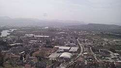
Čapljina is a town and municipality in Bosnia and Herzegovina. It is located in the Herzegovina-Neretva Canton of the Federation of Bosnia and Herzegovina. Čapljina is located on the border with Croatia a mere 20 kilometres (12 mi) from the Adriatic Sea.
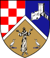
The river Neretva flows through the municipality and flows into the Adriatic just over the border. The town's landmark is a statue of King Tomislav. The Church of Saint Francis of Assisi is also a prominent facet of the town. The municipal coat of arms contains the Croatian chequy, the nearby tower in Počitelj, and Saint Francis of Assisi.
The municipality has a rich archaeological history and untouched wilderness and is starting to develop agricultural tourism. It is also home to Hutovo Blato Park, which contains one of the most diverse bird populations in all Europe. The Croatian town of Metković is located just over the border and there are significant commercial and other links between the two towns new Čapljina International Speedway.
History
Not much is known about this city but it was founded by Romans in 5 BC. However, ancient Greek, and later Roman maps clearly show that the area was populated by several native Illyrian peoples, including the Ardiaei, whom the ancient geographer Strabo lists as one of the three strongest Illyrian peoples – the other two being the Autariatae and the Dardani.[1]
Čapljina is situated in the wider Neretva valley region (the original homeland of ancient Illyrian people of Ardiaei), and its name derives from čaplja which means 'heron'. The Latin word for heron is ardea, a word that bears striking similarity with the name of Ardiaei, and it might possibly be its cognate. This theory opens up many possibilities for the interpretation of the original homeland of the Ardiaei and the etymology of their name. For example, heron might have had totemic pagan value among local Illyrians, due to its presence in this area, and it is not implausible to conclude that one of those Illyrian peoples named itself after a heron, the Ardiaei. The Latin word ardea might be a Latin translation of some original Illyrian word for 'heron' that Romans found when they settled in this area, or the 'ardea' itself, could have been an Illyrian word taken by Romans, who might have slightly altered it and integrated it into their language, the Latin. Indeed, the word Ardiaei is found in ancient Greek sources predating the arrival of Romans and their language to the Illyrian lands. It is also possible that ancient Illyrians or Romans named this place 'the place of heron(s), and the Slavic settlers, who settled in the former Illyrian lands around 6th century A.D. translated the name of this place into their language(s), which in turn gave 'Čapljina', "tha place of heron(s)".[2]
The Prebilovci massacre, in which around 4000 people were killed total, including 600 villagers from the Prebilovci thrown into a pit, is one of the most significant atrocities in this area. Out of about 1000 villagers from Prebilovci, less than 200 survived, 57 families were completely extinguished (including numerous children). After the war, the first conscript from Prebilovci that reached the army age was not until 1962 (Jovan Djurasovic).
Since World War II it has been an important road and rail transportation link, connecting the rest of Bosnia and Herzegovina with the port of Ploče in Croatia. During the 1992–1995 war in Bosnia and Herzegovina the city was taken over by the Croatian Defence Council who expelled the non-Croat population and set up concentration camps for Muslim in the Gabela camp.[3]
During the Summer of 2007 wildfires caused extensive damage throughout the rural part of the municipality.
Settlements
• Bajovci • Bivolje Brdo • Bobanovo selo • Crnići • Čapljina • Čeljevo • Doljani • Domanovići • Dračevo • Dretelj • Dubravica • Gabela • Gabela Polje • Gnjilišta • Gorica • Grabovina • Hotanj • Jasenica • Klepci • Lokve • Modrič • Opličići • Počitelj • Prćavci • Prebilovci • Sjekose • Stanojevići • Struge • Svitava • Ševaš Njive • Šurmanci • Šuškovo naselje • Tasovčići • Trebižat • Višići • Zvirovići
Demographics
| 1948 | |
|
|
|
| ||||||
| 1953 | |
|
|
|
| ||||||
| 1961 | |
|
|
|
| ||||||
| 1971 | |
|
|
|
| ||||||
| 1981 | |
|
|
|
| ||||||
| 1991 | |
|
|
|
| ||||||
| 2013 | |
|
|
|
| ||||||
Ethnic structure by settlements
Absolute ethnic majority
Relative ethnic majority
| Ethnic structure of population of Čapljina municipality, by settlements, 1991 census | ||||||
|---|---|---|---|---|---|---|
| Settlement | total | Croats | Muslims | Serbs | Yugoslavs | others |
| Bajovci | 181 | 176 | 5 | 0 | 0 | 0 |
| Bivolje Brdo | 841 | 256 | 562 | 4 | 6 | 13 |
| Crnići | 50 | 50 | 0 | 0 | 0 | 0 |
| Čapljina | 7,461 | 3,067 | 2,191 | 1,267 | 707 | 229 |
| Čeljevo | 1,058 | 827 | 194 | 1 | 8 | 28 |
| Doljani | 365 | 357 | 0 | 5 | 0 | 3 |
| Domanovići | 1,270 | 326 | 727 | 186 | 21 | 10 |
| Dračevo | 630 | 582 | 0 | 41 | 0 | 7 |
| Dretelj | 576 | 508 | 53 | 3 | 11 | 1 |
| Dubravica | 7 | 1 | 3 | 3 | 0 | 0 |
| Gabela | 2,440 | 2,046 | 32 | 324 | 24 | 14 |
| Gnjilišta | 345 | 338 | 1 | 0 | 0 | 6 |
| Gorica | 456 | 380 | 65 | 1 | 4 | 6 |
| Grabovina | 947 | 817 | 29 | 57 | 29 | 15 |
| Hotanj | 275 | 178 | 93 | 0 | 4 | 0 |
| Jasenica | 165 | 1 | 157 | 0 | 0 | 7 |
| Klepci | 417 | 14 | 0 | 383 | 13 | 7 |
| Lokve | 587 | 0 | 395 | 192 | 0 | 0 |
| Opličići | 1,386 | 108 | 916 | 357 | 0 | 5 |
| Počitelj | 905 | 172 | 660 | 20 | 36 | 17 |
| Prćavci | 260 | 260 | 0 | 0 | 0 | 0 |
| Prebilovci | 174 | 1 | 0 | 171 | 0 | 2 |
| Sjekose | 169 | 146 | 10 | 12 | 0 | 1 |
| Stanojevići | 194 | 31 | 163 | 0 | 0 | 0 |
| Struge | 437 | 284 | 130 | 2 | 16 | 5 |
| Svitava | 319 | 317 | 0 | 0 | 0 | 2 |
| Ševaš Njive | 262 | 69 | 191 | 0 | 2 | 0 |
| Šurmanci | 403 | 354 | 47 | 0 | 2 | 0 |
| Tasovčići | 1,675 | 294 | 511 | 698 | 138 | 34 |
| Trebižat | 1,399 | 1,371 | 9 | 1 | 11 | 7 |
| Višići | 1,788 | 1,207 | 528 | 23 | 15 | 15 |
| Zvirovići | 440 | 431 | 0 | 2 | 0 | 7 |
| total | 27,882 | 14,969 | 7,672 | 3,753 | 1,047 | 441 |
Culture
In the Čapljina area, there are lots of cultural associations such as the following:
Famous People
- Admir Salihović (born 1988), Canadian footballer
- Nikica Jelavić (born 1985), Croatian footballer
- Ivo Prskalo (born 1948), retired Yugoslav and Australian footballer
- Dada Vujasinović (1964–1994), Serbian journalist and news reporter
- Jasmin Repeša (born 1961), Croatian basketball coach
- Pamela Ramljak, Croatian singer
- Marko Vego (1907–1985), Yugoslav archeologist, epigrapher and historian
- Mirsad Fazlagić (born 1943), retired Yugoslav footballer
- Nikola Prce (born 1980), Bosnian handball player
- Dejan Aćimović (born 1963), Croatian actor
- Dragan Bender (born 1997), Croatian basketball player
- Vukašin Mandrapa (? - 1943), Serbian Orthodox saint
Sport
References
Notes
- ↑ Strab. 7.5
- ↑ Adzanela (Axhanela) Ardian, Illyrian Bosnia and Herzegovina-an overview of a cultural legacy, 2004, http://www.academia.edu/2490281/Illyrian_Bosnia_and_Herzegovina-an_Overview_of_a_Cultural_Legacy_Ancient_Illyrians_of_Bosnia_and_Herzegovina
- ↑ Predmet Prlic i drugi (IT-04-74) - Optuznica
- ↑ 1948 census.
- ↑ 1953 census.
- ↑ 1961 census.
- ↑ 1971 census.
- ↑ 1981 census.
- ↑ 1991 census.
- ↑ 2013 census.
Books
- Konačni rezultati popisa stanovništva od 15. marta 1948. godine (in Serbo-Croatian). 9. Belgrade: Savezni zavod za statistiku i evidenciju. 1955.
- Nacionalni sastav stanovništva SFR Jugoslavije: podaci po naseljima i opštinama (in Serbo-Croatian). 1. Belgrade: Federal Statistical Office. 1991.
- Nacionalni sastav stanovništva SFR Jugoslavije: podaci po naseljima i opštinama (in Serbo-Croatian). 2. Belgrade: Federal Statistical Office. 1994.
- Nacionalni sastav stanovništva SFR Jugoslavije: podaci po naseljima i opštinama (in Serbo-Croatian). 3. Belgrade: Federal Statistical Office. 1994.
- Nacionalni sastav stanovništva: rezultati za Republiku po opštinama i naseljenim mjestima 1991. (in Serbo-Croatian). Sarajevo: State Bureau for Statistics of the Republic of Bosnia and Herzegovina. 1994.
- Popis stanovništva 1953. (in Serbo-Croatian). 11. Belgrade: Federal Statistical Office. 1960.
| Wikimedia Commons has media related to Čapljina. |
Municipalities of the Herzegovina-Neretva Canton | ||
|---|---|---|
| Countries |  | ||||||
|---|---|---|---|---|---|---|---|
| Places | |||||||
| Tributaries |
| ||||||
| Lakes |
| ||||||
| Related articles | |||||||