Vareš
| Vareš Вареш | ||
|---|---|---|
| ||
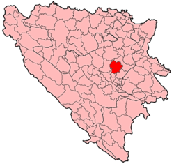 Location of Vareš within Bosnia and Herzegovina. | ||
 Vareš Location of Vareš | ||
| Coordinates: 44°10′N 18°20′E / 44.167°N 18.333°E | ||
| Country |
| |
| Government | ||
| • Municipality president | Zdravko Marošević (HDZ BiH) | |
| Area | ||
| • Total | 390,1 km2 (1,506 sq mi) | |
| Population (2013 census) | ||
| • Total | 9,556 | |
| • Density | 25/km2 (60/sq mi) | |
| Time zone | CET (UTC+1) | |
| • Summer (DST) | CEST (UTC+2) | |
| Area code(s) | +387 32 | |
| Website | http://www.vares.info | |
Vareš is a town and municipality in central Bosnia and Herzegovina, famous for the local mining activities and production of iron. It is part of the Zenica-Doboj Canton and the Federation of Bosnia and Herzegovina.
History
Early history
The town of Vareš has a long history with remains of metallurgical activities dating back to Bronze Age. Also during the Roman era, the town was famous for its miners and smiths.
Middle ages
During Middle Ages the Bosnian kings had their center in close proximity of the modern city of Vareš. Bosnia's greatest king, Tvrtko, considered the Vareš' village Duboštica for the center of his kingdom, since it was the mining center of his country.
Medieval
The remains of the medieval royal city and castle Bobovac were recently proclaimed as national monuments, as was the Catholic Church of St. Michael in the town of Vareš. Oldest preserved Catholic church in Bosnia can be found in the town, built in early 17th century. The town was earlier dominated by Catholic population. The church books are among the oldest preserved in Bosnia and date back to 1643.
Austro-Hungarian Empire
During the Austrian rule of Bosnia and Herzegovina the iron-works of Vareš were an important exporter of various iron products to the rest of the Habsburg empire. In 1891, first blast furnace in Bosnia and Herzegovina is built here. That blast furnace still exists, but it ceased it's operations in 1990.
World War I
In the 1910s World War I, men of the town were subject to draft, and served in the regiment BH-1, formally based in Sarajevo. They mostly saw action in the Italian and Galician fronts. It should be noted that the church bell was taken and melted so it could be used to produce war material.
World War II
During the Second World War, Vareš was an Ustashe stronghold. Due to the value of its industry the city was well defended, and saw several attacks by Partisans and Chetniks on both the city and surrounding villages. NEED REFERENCE FOR THIS
Bosnian War (1992–95)
In the Bosnian War that lasted from early 1992 until December 1995, the town of Vareš was at first controlled by the Croatian Defence Council (HVO), while the rest of the municipality was divided between the forces of Army of the Republic of Bosnia and Herzegovina (ARBih) and Army of Republika Srpska. In November 1993, the Army of the Republic of Bosnia and Herzegovina took over the town, while the Croat civilian population fled, before the ARBiH arrived, through Serb lines to Kiseljak. The remaining HVO units took hold in the village of Daštansko, where they remained until the Dayton Agreement was signed in November 1995. In 1994, the village of Brgule fell to the Army of the Republic of Bosnia and Herzegovina. Before, it vas VRS's territory. Small part of the Croat population from Vareš returned in 1995, those who have not returned have mostly emigrated to West European countries, with a significant number settling in Knin, Croatia.
Geography
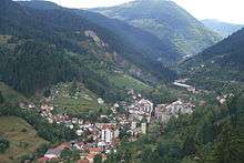
Vareš is a mountainous town located 45 km from Sarajevo in the valley of the small Stavnja River 828 m above sea level surrounded by the massive high Kapija, Stijene, Zvijezda and Perun Mountains, named after Perun / Перун, the highest god of the Slavic pantheon (Perkūnas/Perkons). The town is rich with archeological findings from different epochs – on several surrounding locations are found remains of prehistorical period, such as copper artifacts in Brgula.
In the town center itself, there is an old stone bridge that resembles to the majority of one arched bridges from Ottoman period. This bridge is considered to be similar by the building method to the Old Bridge in Mostar.
Demographics
1971
23,523 total
- 11,134 Croats (47.33%)
- 6,631 Bosniaks (28.18%)
- 5,166 Serbs (21.96%)
- 307 Yugoslavs (1.30%)
- 285 Others (1.23%)
1991
22,203 total
- 9,016 Croats (40.61%)
- 6,714 Bosniaks (30.24%)
- 3,644 Serbs (16.41%)
- 2,071 Yugoslavs (9.32%)
- 758 Others (3.44%)
The town of Vareš had a total population of 5,888, composed of:
- 3,035 Croats (51.54%)
- 1,068 Bosniaks (18.13%)
- 627 Serbs (10,64%)
- 859 Yugoslavs (14.58%)
- 299 others and unknown (5.07%)
Tourism
The Vareš region also has possibilities for winter tourism development. Due to its position and elevation snow stays longer than in other regions, and the beautiful areas surrounding it are really good for skiing and skating. The mountain resort Doli is located on Zvijezda Mountain.
Places in the municipality
Bijelo Borje, Blaža, Borovica Donja, Borovica Gornja, Borovičke Njive, Brda, Brezik, Brgule, Budoželje, Čamovine, Ćeće, Dabravine, Daštansko, Debela Međa, Diknjići, Dragovići, Draževići, Duboštica, Hodžići, Ivančevo, Javornik, Kadarići, Karići, Kokoščići, Kolovići, Kopališta, Kopijari, Krčevine, Kunosići, Letevci, Ligatići, Luke, Ljepovići, Mijakovići, Mir, Mižnovići, Mlakve, Naseoci, Neprivaj, Oćevija, Okruglica, Orah, Osoje, Osredak, Ostrlja, Pajtov Han, Pajtovići, Planinica, Pobilje, Podjavor, Pogar, Položac, Poljanice, Pomenići, Pržići, Pržići Kolonija, Radonjići, Radoševići, Ravne, Rokoč, Samari, Semizova Ponikva, Seoci, Sjenokos, Slavin, Sršljenci, Strica, Striježevo, Stupni Do, Šikulje, Tisovci, Toljenak, Tribija, Vareš, Vareš Majdan, Vijaka Donja, Vijaka Gornja, Višnjići, Zabrezje, Zaruđe, Zubeta, Zvijezda, Žalja i Žižci.
List of mayors
- Ivica Džoja 1954-1963;KPJ
- Mile Markić 1963-197x;KPJ
- Slobodan Milanović 197x-197x;KPJ
- Salko Operta 1974-1978;KPJ
- Rešad Žutić 1981-1983;KPJ
- Željko Franjkić 1986-1988;KPJ
- Pero Jarčević 1988-1989;KPJ
- Mladen Zovko 1989-1990;KPJ
- Dario Andrijević 1990-1992;KPJ - SDP
- Anto Pejčinović 1992-1993 HDZ
- Mervana Hadžimurtezić 1992-1998 SDA
- Samir Musa 1998-2000 SDA (joint mayor)
- Pavao Vidović 1998-2000 HDZ (joint major)
- Ermin Musa 2000-2001 SDA
- Hamdo Fatić 2001-2012 SDP
- Avdija Kovačević 2012-2016 SDA
- Zdravko Marošević 2016- HDZ
Notable people
- Borislav Stjepanović, actor
- Goran Ivandić, musician
- Slaven Stjepanović, footballer
- Željko Ivanković, poet and writer
- Matija Divković, Bosnian Franciscan writer
External links
- http://www.vares.pp.se/
- http://www.vares-x.com.ba/
- Web magazine with current information on the city - in Croatian
- http://www.zupavares.com/
- http://www.vares.info/
- Tragovima bosanskog kraljevstva - Tourist route for medieval Bosnia
- Trail of the Bosnian Kingdom - Cultural Tourism in Vares
Municipalities of the Zenica-Doboj Canton | ||
|---|---|---|
Coordinates: 44°10′N 18°20′E / 44.167°N 18.333°E
| Wikimedia Commons has media related to Vareš. |