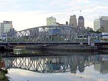
Bridge Street Bridge (Newark)
| Bridge Street Bridge | |
|---|---|
 | |
| Coordinates | 40°44′42″N 74°09′57″W / 40.7451°N 74.1657°WCoordinates: 40°44′42″N 74°09′57″W / 40.7451°N 74.1657°W |
| Carries |
(Bridge Street & Harrison Avenue) |
| Crosses | Passaic River |
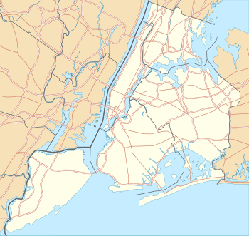
| Locale | Newark and Harrison, New Jersey |
| Owner | Essex County |
| Characteristics | |
| Design | Through truss swing bridge |
| Material | steel |
| Total length | 371.1 feet (113.1 m) |
| Width | 40.4 feet (12.3 m) |
| Longest span | 122.1 feet (37.2 m) |
| Number of spans | 2 |
| Clearance above | 12 feet (3.7 m)[1] |
| Clearance below | 6.9 feet (2.1 m) |
| History | |
| Constructed by | American Bridge Company |
| Opened | 1913 |
| Statistics | |
| Daily traffic | 11,820 |
 Bridge Street Bridge Location of the bridge | |
The Bridge Street Bridge is a swing bridge over the Passaic River connecting Newark and Harrison, New Jersey. It is the 10th bridge from the river's mouth at Newark Bay and is 5.7 miles (9.2 km) upstream from it.[1] Carrying vehicular traffic, the roadway is designated County Route 508.[2]
The span is a rim-bearing Pratt thru truss swing span supported on ashlar substructure with concrete caps originally built by the American Bridge Company. It opened in 1913 and underwent significant rehabilitation in 1981.[3] It is listed on the New Jersey Register of Historic Places (ID#3093) [4] The bridge was re-lamped in 2012.[5][6] The bridge's electric motor was damaged by Hurricane Sandy in 2012, requiring replacement.[7]
Like the other vehicular swing bridges in Newark, the Jackson Street Bridge and the Clay Street Bridge,[3] it crosses over the tidal navigable portion of the river.[1] and is required to open with 4-hour notice.[8] The swing bridge of Newark are expected to open as much as 10 times a day during a massive clean-up of the Passaic starting in 2015 to allow barges to move contaminated sludge dredged from the river bottom raingi concerns about their releiabilty.[9] As of 2016 studies were under to study its replacement.[10]
History
The site of Bridge Street Bridge has been a river crossing since the colonial era. In 1790 the state legislature decided that "public good would be served by a 64 feet (20 m) wide road from Paulus Hook to the Newark Courthouse". By 1795 a bridge over the Hackensack 950 feet (290 m) long and another over the Passaic 492 feet (150 m) long were built creating an uninterrupted toll road connection.[11] The road between them is known as the Newark Turnpike.
See also
- List of crossings of the Lower Passaic River
- List of bridges, tunnels, and cuts in Hudson County, New Jersey


| Wikimedia Commons has media related to Bridge Street Bridge (Newark). |
References
- U.S. Federal Highway Administration, Washington, D.C. (2010). "Bridge Street over Passaic River, Newark, Essex County, New Jersey." National Bridge Inventory, via Uglybridges.com. Structure No. 0700H03.
- 1 2 3 Lower Passaic River Restoration Project Commercial Navigation Analysis (PDF) (Report). United States Army Corps of Engineers. July 2, 2010. Retrieved 2012-03-19.
- ↑ NJDOT County Route 508 Straight Line Diagram by the New Jersey Department of Transportation
- 1 2 Clay Street Bridge (PDF). New Jersey Historic Bridge Data (Report). New Jersey Department of Transportation. November 4, 2002. Retrieved 2012-06-05.
- ↑ "New Jersey and National Registers of Historic Places - Essex County". NJ DEP - Historic Preservation Office. Retrieved 2012-08-05.
- ↑ "Jackson Street Bridge In Lights « Newark's Riverfront". Newarksriver.wordpress.com. 2012-05-01. Retrieved 2012-08-08.
- ↑ Newark Emergency Contract Award
- ↑ http://www.theobserver.com/?p=16103
- ↑ "Drawbridge Operation Regulations; Passaic River, NJ (Coast Guard 33 CFR Part 117) [CGD01–97–020] RIN 2115–AE47" (PDF). Rules and Regulations. Federal Register /Vol. 63, No. 120. June 23, 1998. Retrieved 2012-08-05.
- ↑ Higg, Larry (October 31, 2014). "Hudson County, Harrison worried old draw bridges opening during Passaic River dredging could fail". The Star-Ledger. Retrieved 2015-05-21.
- ↑ http://www.njtpa.org/getmedia/c1ca5f18-f06e-4107-8179-b483d711c832/bridge-street.pdf.aspx
- ↑ Olsen, Kevin K (2008), A Great Conveniency A Maritime History of the Passaic River, Hackensack River and Newark Bay, American History Imprints, ISBN 978-0-9753667-7-6