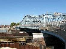
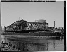
Jackson Street Bridge
| Jackson Street Bridge | |
|---|---|
 | |
| Coordinates | 40°44′01″N 74°09′19″W / 40.73361°N 74.15528°WCoordinates: 40°44′01″N 74°09′19″W / 40.73361°N 74.15528°W |
| Carries |
Jackson Street & |
| Crosses |
Passaic River Raymond Boulevard |
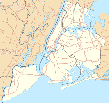
| Locale |
Newark and Harrison, Northeastern New Jersey |
| Owner | City of Newark |
| Characteristics | |
| Design | Swing bridge |
| Total length | 466.9 feet (142.3 m) |
| Width | 40.4 feet (12.3 m) |
| Longest span | 171.9 feet (52.4 m) |
| Number of spans | 2 |
| Clearance above | 16.7 feet (5.1 m) |
| Clearance below | 15.1 feet (4.6 m) (low tide)[1] |
| History | |
| Designer | J. Owen |
| Engineering design by | McCann Fagan Iron Works |
| Construction begin | 1897 |
| Opened | 1903 |
 Jackson Street Bridge | |
The Jackson Street Bridge is a bridge on the Passaic River between Newark and Harrison, New Jersey.[2] The swing bridge is the 6th bridge from the river's mouth at Newark Bay and is 4.6 miles (7.4 km) upstream from it.[1] Opened in 1903 and substantially rehabilitated in 1991 it is listed on the New Jersey Register of Historic Places (ID#1274) and is eligible for the National Register of Historic Places.[3][4] The bridge was re-lamped in 2012.[5][6]
The lower 17 miles (27 km) of the 90-mile (140 km) long Passaic River downstream of the Dundee Dam is tidally influenced and navigable,[1] but due to the limited maritime traffic the bridge is infrequently required to open. It is one of three functional vehicular and pedestrian swing bridges in the city, the others being the Clay Street Bridge and the Bridge Street Bridge.[7] Since 1998, rules regulating drawbridge operations require a four-hour notice for them to be opened.[8]
The bridge crosses the river at a point where former industrial uses are giving way to commercial, residential, and recreational development. The US Army Corps of Engineers is undertaking a rehabilitation of the river including oversight of environmental remediation and reconstruction of bulkheads.[1]
At its southern end in the Newark Ironbound, the bridge crosses over Raymond Boulevard, a major thoroughfare in the city between the Pulaski Skyway and Downtown Newark. It is adjacent to Riverbank Park and the new Joseph G. Minish Passaic River Waterfront Park being developed along the riverfront.[9][10]
At its northern end the bridge in Harrison begins a street named for Frank E. Rodgers, once one of the longest serving mayors of the United States. The district along the waterfront has been largely cleared of former industrial buildings and has become home to Red Bull Arena.[11][12]
See also
- List of bridges documented by the Historic American Engineering Record in New Jersey
- List of bridges, tunnels, and cuts in Hudson County, New Jersey
- List of crossings of the Lower Passaic River
References
- 1 2 3 4 "Lower Passaic River Restoration Project Commercial Navigation Analysis" (PDF). United States Army Corps of Engineers. July 2010. Archived from the original (PDF) on 2015-03-19. Retrieved 2012-03-19.
- ↑ "Jackson Street Bridge". Bridgehunter. Retrieved 2012-08-05.
- ↑ "Jackson Street over Raymond Boulevard and Passaic River" (PDF). New Jersey Historic Bridge Data. NJDOT. 2001. Retrieved 2012-08-06.
- ↑ "New Jersey and National Registers of Historic Places - Essex County". NJ DEP - Historic Preservation Office. January 10, 2010. Retrieved 2012-08-05.
- ↑ "Jackson Street Bridge In Lights « Newark's Riverfront". Newarksriver.wordpress.com. 2012-05-01. Retrieved 2012-08-08.
- ↑ Newark Emergency Contract Award
- ↑ Richman, Steven M. (2005). The Bridges of New Jersey: Portraits of Garden State Crossings. Piscataway, NJ: Rutgers University Press. p. 151.
- ↑ "Drawbridge Operation Regulations; Passaic River, NJ (Coast Guard 33 CFR Part 117" (PDF). Rules and Regulations. Federal Register Vol. 63, No. 120. June 23, 1998. Retrieved 2012-08-05.
- ↑ "Joseph G. Minish Passaic River Waterfront Park and Historic Area". US Army Corps of Engineers. Retrieved 2012-08-05.
- ↑ Adarlo, Sharon (July 8, 2012). "Newark Reintroduces Itself to River". Wall Street Journal. Retrieved 2012-08-05.
- ↑ Smothers, Ronald (May 27, 2007), "New Jersey Town Is Replacing Its Old Factories With Waterfront Homes", The New York Times, retrieved 2012-08-05
- ↑ "Town of Harrison Waterfront Redevelopment Plan". Heyer, Gruel and Associates. 2007. Retrieved 2012-08-05.
External links
- Ronsari Image Jackson Street Bridge
- Jackson Street Bridge on Flickr
- Historic American Engineering Record (HAER) No. NJ-54, "Jackson Street Bridge"