Swing bridge
 | |
| Ancestor | Truss bridge, cantilever bridge |
|---|---|
| Related | Other moving types: Bascule bridge, drawbridge, jetway, vertical-lift bridge, tilt bridge |
| Descendant | Gate-swing bridge - see Puente de la Mujer |
| Carries | Automobile, truck, light rail, heavy rail |
| Span range | Short |
| Material | Steel |
| Movable | Yes |
| Design effort | Medium |
| Falsework required | No |
A swing bridge is a movable bridge that has as its primary structural support a vertical locating pin and support ring, usually at or near to its center of gravity, about which the turning span can then pivot horizontally as shown in the animated illustration to the right. Small swing bridges as found over canals may be pivoted only at one end, opening as would a gate, but require substantial underground structure to support the pivot.
In its closed position, a swing bridge carrying a road or railway over a river or canal, for example, allows traffic to cross. When a water vessel needs to pass the bridge, road traffic is stopped (usually by traffic signals and barriers), and then motors rotate the bridge horizontally about its pivot point. The typical swing bridge will rotate approximately 90 degrees, or one-quarter turn; however, a bridge which intersects the navigation channel at an oblique angle may be built to rotate only 45 degrees, or one-eighth turn, in order to clear the channel.
Advantages

- As this type requires no counterweights, the complete weight is significantly reduced as compared to other moveable bridges.
- Where sufficient channel is available to have individual traffic directions on each side, the likelihood of vessel-to-vessel collisions is reduced.
- The central support is often mounted upon a berm along the axis of the watercourse, intended to protect the bridge from watercraft collisions when it is opened. This artificial island forms an excellent construction area for building the movable span as the construction will not impede channel traffic.
Disadvantages

- For a symmetrical bridge, the central pier forms a hazard to navigation. Asymmetrical bridges may place the pivot near one side of the channel.
- Where a wide channel is not available, a large portion of the bridge may be over an area that would be easily spanned by other means.
- A wide channel will be reduced by the center pivot and foundation.
- When open, the bridge will have to maintain its own weight as a balanced double cantilever, while when closed and in use for traffic, the live loads will be distributed as in a pair of conventional truss bridges, which may require additional stiffness in some members whose loading will be alternately in compression or tension.
- If struck from the water near the edge of the span, it may rotate enough to cause safety problems (see Big Bayou Canot train disaster).
Examples

Albania
- Buna River Bridge, in Shkodra, Albania.
Argentina
- Puente de la Mujer, an asymmetrical cable-stayed span.
Australia
- Pyrmont Bridge, Sydney, Australia. (opened 1902. Closed to traffic, 1988. Still in use as a pedestrian bridge.)
- Glebe Island Bridge, Sydney, Australia. (Opened 1901. Tramway defunct. Closed to traffic, 1995; supplanted by Anzac Bridge. Still in existence.)
- Victoria Bridge, Townsville, Queensland, Australia. (Opened 1889, closed to traffic 1975. Still in use as a foot bridge.)
- The Sale Swing Bridge, Sale, Victoria, Australia. (Opened 1883. Closed to traffic in 2002. Restored to full working order in 2006.)
- Dunalley Bridge, Dunalley, Tasmania Still in use.
Belize
- Belize City Swing Bridge, Belize City, Belize. Oldest such bridge in Central America and one of the few manually operated swing bridge in world still in operation. (Restored in 2000s)
Canada
Egypt


- The longest swing bridge span is 340 metres, by the El Ferdan Railway Bridge across the Suez Canal.
France
- Le pont tournant rue Dieu, across the Canal Saint-Martin in Paris, is a distinctive location in the 1938 film Hôtel du Nord, and is featured in the opening shot of the film.
Germany
- Kaiser-Wilhelm-Brücke in Wilhelmshaven, built in 1907, with the length of 159m, it was once Europe's biggest swing bridge
India
- Garden Reach Road Swing Bridge, for Calcutta Port, Kidderpore, Kolkata
- Poira-Corjuem Bridge, for GSIDC, Corjuem, Goa by Rajdeep Buildcon Pvt. Ltd.
Ireland
- Samuel Beckett Bridge, Dublin, Ireland
- Seán O'Casey Bridge, Dublin, Ireland
- Michael Davitt Bridge, County Mayo, Ireland
- Portumna bridge, between County Galway and County Tipperary, Ireland
Italy

- Ponte Girevole, Taranto (built in 1887) – a very unusual type, with two spans that separate at the bridge's center and pivot sideways from the bridge's outer ends.[2][3]
Latvia
The Netherlands
The "Abtsewoudsebrug" in Delft, close to the Technische Universiteit Delft, is a bridge of this type. 52°0′5.71″N 4°21′50.10″E / 52.0015861°N 4.3639167°E
There's another one on the channel between Ghent (Belgium) and Terneuzen (The Netherlands) at Sas Van Gent.[4]
New Zealand
- Kopu Bridge, Waihou River, near Thames, New Zealand
(n.b. "swing bridge" in New Zealand refers to a flexible walking track bridge which "swings" as you walk across[5])
Panama
- A swing bridge at the Gatun Locks provides the only road passage over the Atlantic side of the Panama Canal. This is a small bridge that swings out from each side. Another larger swing bridge at the Miraflores Locks is on the Pacific side but is rarely used, having been supplanted by the Bridge of the Americas and the Centennial Bridge.
Ukraine
- Varvarivskyi Bridge over Southern Bug in Mykolaiv, with Europe's largest span (134 m) [6]
United Kingdom

In the UK, there is a legal definition in current statute as to what is, or is not a 'swing bridge' [7]
- Acton swing bridge - road
- Barmouth Bridge - rail
- Beccles swing bridge - rail
- Bethells Swing Bridge
- Boothferry swing bridge at Boothferry, Yorkshire (see article for image)
- Caernarfon swing bridge
- Connaught Crossing in London Docklands, built as a low-rising swing bridge to allow marine traffic in the Royal Docks to pass at a place when the proximity of London City Airport meant a higher fixed bridge was not practicable.
- Crosskeys Bridge - carries the A17 road over the River Nene in Lincolnshire
- Folkestone Harbour railway station - railway bridge on the branch line.
- Goole railway swing bridge
- Glasson Dock swing bridge
- Hawarden Railway Bridge - rail (now deactivated).[8]
- Hull, England docks branch bridge - rail
- Kennet and Avon Canal at Tyle Mill Lock, Sulhamstead, Berkshire
- Kincardine Bridge - crossing the Firth of Forth from Falkirk council area to Kincardine-on-Forth, Fife
- Leeds and Liverpool Canal Has a large number of swing bridges, especially between Bingley and Skipton and Burscough and Liverpool. Many are manually operated, carrying only farm tracks, but a significant number carry road traffic and are mechanised for boater operation.
- Manchester Ship Canal at Latchford, Stockton Heath and Lower Walton in Warrington, and also slightly further west at Moore. Near the eastern end of the canal in Salford, the Barton Road Swing Bridge is adjacent to the Barton Swing Aqueduct - a 234-foot, 800-ton trough holding some 800 tons of water (retained by gates at either end) swings so that it is at right angles to the Bridgewater Canal to allow ships to pass up the Ship Canal.
- Oulton Broad swing bridge - rail
- Reedham Swing Bridge (52°33′32″N 1°34′21″E / 52.55887°N 1.57237°E) - rail
- Ross Bridge, Penzance
- Selby swing bridge - rail
- Somerleyton swing bridge
- Trowse Bridge at Norwich. Carries the electrified Great Eastern Main Line over the River Yare. It is the only overhead electrified swing bridge in the country.
- Tyne swing bridge at Newcastle Upon Tyne, which has an 85.7 metre cantilevered span with a central axis of rotation able to move through 90° to allow vessels to pass on either side of it.
- Whitby Swing Bridge over the River Esk at Whitby, North Yorkshire, with two swing leaves (though only one is usually opened).
- Operation of the Sulhamstead Tyle Mill swing bridge on the Kennet & Avon Canal
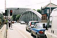
Bridge with road traffic 
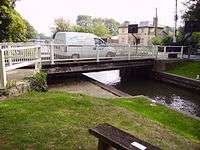
Bridge opening 
Bridge with canal traffic
United States

The largest double swing-span bridge in the United States is the 3,250 feet (990 m) long, 450 feet (140 m) navigable span, 60 feet (18 m) clearance George P. Coleman Memorial Bridge.[9]
- Alanson Swing Bridge, billed as the world's shortest swing bridge, crossing the Crooked River in Alanson, Michigan
- Ben Sawyer Bridge, connecting the city of Mount Pleasant, South Carolina, with Sullivan's Island
- Berkley–Dighton Bridge (1896), connecting the towns of Berkley and Dighton, Massachusetts, crossing the Taunton River; removed in 2010. The replacement bridge is not a swing structure.
- Blackburn Point Road Bridge, over the Intracoastal Waterway in Osprey, Florida
- Bridge No. 4455, Central Avenue over Lewis Gut, Bridgeport, Connecticut (1924 steel swing bridge)
- Bridgeport Swing Bridge, Bridgeport, Alabama (demolished in late 1970s, replaced with new span)
- Burlington Northern Railroad Bridge 9.6 (or BNSF Railway Bridge 9.6), crossing the Columbia River, from Portland, Oregon, to Vancouver, Washington, built in 1908.[10]
- Center Street Bridge, Cleveland, Ohio (1901)[11]
- Chef Menteur Bridge, near Slidell, Louisiana
- Chincoteague Channel Swing Bridge, Chincoteague, Virginia (demolished)
- Columbus Drive Bridge, Tampa, Florida, a bobtail swing bridge over the Hillsborough River
- CSX Rail Bridge, Indiantown, Florida[12]
- Curtis Creek Rail Bridge, Baltimore, Maryland[13]
- Deweyville Swing Bridge, crossing the Sabine River east of Deweyville, Texas
- Dubuque Rail Bridge, crossing the Mississippi River and connecting Dubuque, Iowa with East Dubuque, Illinois
- East Haddam Bridge, Route 82 over the Connecticut River, East Haddam, Connecticut (1913)
- Fort Madison Toll Bridge, crossing the Mississippi River and connecting Fort Madison, Iowa with Niota, Illinois
- Fort Pike Bridge, near Slidell and New Orleans, Louisiana
- Fort Denaud Bridge, near LaBelle and Alva, Florida[14]

- Figure Eight Island Bridge, north of Wilmington, North Carolina
- Frederick Douglass Memorial Bridge, Washington, D.C.
- Gasparilla Island Bridge, Built in 1958, this bridge is used for passage between Placida, FL to the island of Boca Grande. A replacement bridge is under construction, with projected completion in August 2016.
- George P. Coleman Memorial Bridge, over the York River between Yorktown and Gloucester Point, Virginia
- Government Bridge on the Mississippi River between Davenport, Iowa and Rock Island, Illinois (1896)
- Grand Haven GTW RR Swing Bridge, connecting Grand Haven and Ferrysburg, Michigan[15]
- Grand Rapids Swing Bridge, Grand Rapids, Michigan
- Grosse Ile Toll Bridge and nearby Wayne County Bridge, Grosse Ile, Michigan
- Harlem River bridges in New York City, including from south to north:
- Harmar Railroad Bridge, Marietta, Ohio
- Hodgdon Island Bridge, Boothbay, Maine. This is one of two manual swing bridges in Maine (see Songo Locks in Naples, Maine)
- I Street Bridge, Sacramento, California
- India Point Railroad Bridge, Providence, Rhode Island crossing the Seekonk River
- International Railway Bridge connecting Buffalo, New York and Fort Erie, Ontario, Canada [16]
- La Crosse Rail Bridge, crossing the Mississippi River between La Crescent, Minnesota, and La Crosse, Wisconsin
- Livingston Avenue Bridge, Albany, New York
- Mathers Bridge, connecting Merritt Island to Indian Harbour Beach, Florida across the Banana River
- Middle Branch of Patapsco River Rail Bridge, near Camden Yards, Baltimore, Maryland[17]
- Mystic River Railroad Bridge, Mystic, Connecticut, carries Amtrak's Northeast Corridor tracks over the Mystic River.[18]
- New Bedford-Fairhaven Bridge, connecting New Bedford and Fairhaven, Massachusetts
- New Richmond Swing Bridge, near Fennville, Michigan
- Norfolk Southern Railway Bridge crossing the Maumee River, Toledo, Ohio[19][20]
- Norfolk Southern Railway Bridge crossing the Ocmulgee River in Lumber City, Georgia (2,800 feet (850 m) long; built 1916) (electrical swing components removed)[21]
- Northern Avenue Bridge over Fort Point Channel in Boston, Massachusetts (1908 steel truss)
- North Landing Bridge, built in 1950s, on the Atlantic Intracoastal Waterway where it forms part of the border between Chesapeake and Virginia Beach, Virginia,[22]
- Omaha Road Bridge Number 15, an asymmetrical single-track railroad bridge over the Mississippi River between Saint Paul and Lilydale, Minnesota (1916)
- Oregon Slough Railroad Bridge (1908), Portland, Oregon
- Padanaram Bridge on the causeway protecting Apponagansett Bay in Dartmouth, Massachusetts[23]
- Passaic River in Newark, New Jersey
- Pennsylvania Railroad's Shellpot Branch over the Christina River in Wilmington, Delaware (original two-track bridge replaced with a single-track bridge in 2003)
- Pennsylvania Railroad's South Philadelphia Branch Bridge over the Schuylkill River, Philadelphia, Pennsylvania
- Point Street Bridge, Providence, Rhode Island crossing the Providence River
- Portal Bridge, carrying the Northeast Corridor over the Hackensack River between Kearny and Secaucus, New Jersey
- Providence & Worcester railroad bridge, Middletown, Connecticut
- Richard V. Woods Memorial Bridge over the Beaufort River/Intracoastal Waterway in Beaufort, South Carolina
- Riverside-Delanco Bridge over Rancocas Creek in New Jersey
- Rock Island Swing Bridge over the Mississippi River between Inver Grove Heights and St. Paul Park, Minnesota
- Sakonnet River rail bridge, crossing the Sakonnet River between Tiverton and Portsmouth, Rhode Island
- Saugatuck River Bridge (Bridge No. 1349), Route 136 over the Saugatuck River, Westport, Connecticut (1884 iron-truss swing bridge)
- Shaw Cove Railroad Bridge, New London, Connecticut, carrying Amtrak's Northeast Corridor tracks over the entrance to Shaw Cove in New London[18]
- Snow-Reed Swing Bridge, Fort Lauderdale, Florida, crossing the New River and connecting the Sailboat Bend neighborhood with the Riverside Park neighborhood
- Songo Locks Bridge, Naples, Maine; carries Songo Lock Road over the Songo River just upstream of the lock. Not to be confused with a former swing bridge about two miles upstream which carried US 302 until replaced with a fixed span in May 2012.
- South Bristol, Maine Asymmetric swing bridge connecting Rutherford Island to the mainland.
- Southport, ME connects Southport Island to Boothbay Harbor on Route 27.
- Spokane Street Bridge over the Duwamish Waterway in Seattle, Washington, built 1991. Features two reinforced concrete, serial swing spans, each rotating 45 degrees[24]
- St. Joseph Swing Bridge over the Missouri River, St. Joseph, Missouri (1904)[25]
- Surf City Bridge, Surf City, North Carolina
- Trail Creek Swing Bridge in Michigan City, Indiana, carrying the Michigan Central Railroad (now operated by Amtrak)
- Torry Island Swing Bridge, Torry Island, Florida
- Union Pacific Railroad (former CNW) Bridge crossing the Mississippi River, Clinton, Iowa[26][27]
- Victory Bridge, crossing the Raritan River in Perth Amboy, New Jersey (taken down in 2003)
- Woods Memorial Bridge over the Beaufort River in Beaufort, South Carolina[28]
- Yancopin Bridge, Arkansas River, southeastern Arkansas. Former Missouri Pacific railroad bridge with separate vertical-lift and swing trusses now part of rail-trail; swing span now manually operated
- State Hwy 87 northbound bridge the eastern boundary of Bridge City, Texas

Vietnam
See also
- Movable bridges for a list of other movable bridge types
References
| Wikimedia Commons has media related to Swing bridges. |
- ↑ "Burned bridge fate in CN's hands, officials say". CBC.ca. 31 October 2013. Retrieved 31 October 2013.
- ↑ "Photograph of the Ponte Girevole (Taranto, Italy) while fully open" (JPG). Cityofart.net. Retrieved 2013-02-09.
- ↑ "Apertura Ponte Girevole Taranto". YouTube. 2008-04-16. Retrieved 2016-02-17.
- ↑ "Draaibrug over het kanaal Gent-Terneuzen bij Sas van Gent". Beeldbank Zeeland Seaports. 1977-08-01. Retrieved 2016-02-17.
- ↑ Walkway swingbridge manual / prepared and finalised by S. Chiet ... [et al.] Published by : New Zealand Forest Service, Wellington [N.Z.] : 1986.
- ↑ "History". Kyivdiprotrans Institute. Retrieved 19 August 2013.
- ↑ Highways Act 1980. London: HMSO. 1980.
- ↑ "Shotton Steelworks - general scenes". Archived from the original on January 11, 2011. Retrieved February 1, 2008.
- ↑ "BUILDING BIG: Databank: George P. Coleman Bridge". Pbs.org. 1995-05-13. Retrieved 2016-02-17.
- ↑ Wood Wortman, Sharon; Wortman, Ed (2006). The Portland Bridge Book (3rd Edition). Urban Adventure Press. pp. 119–120. ISBN 0-9787365-1-6.
- ↑ "Google Maps". Maps.google.com. Retrieved 2016-02-17.
- ↑ "Google Maps". Maps.google.com. Retrieved 2016-02-17.
- ↑ "Google Maps". Maps.google.com. Retrieved 2016-02-17.
- ↑ http://www.hendryfla.net/county_engineer/historic_fort_denaud_swing_span_bridge.php
- ↑ "Bridge: GTW Grand Haven Swing Bridge". Michiganrailroads.com. Retrieved 2016-02-17.
- ↑ "International Railroad Bridge". Buffaloah.com. Retrieved 2016-02-17.
- ↑ "Google Maps". Maps.google.com. Retrieved 2016-02-17.
- 1 2 Amtrak Moveable Bridge Smart Card
- ↑ "Google Maps". Maps.google.com. Retrieved 2016-02-17.
- ↑ "Photo: NS 9869 Norfolk Southern GE C40-9W (Dash 9-40CW) at Toledo, Ohio by Matt Smith". Railpictures.net. Retrieved 2016-02-17.
- ↑ "Google Maps". Maps.google.com. Retrieved 2016-02-17.
- ↑ "North Landing Bridge (Mt. Pleasant Rd)".
- ↑ "Google Maps". Maps.google.com. Retrieved 2016-02-17.
- ↑ "West Seattle Connection: World's Only Hydraulically Operated Double-Leaf Concrete Swing Bridge" (PDF). City of Seattle Engineering Department. Retrieved 25 February 2014.
- ↑ "Freight - Q324 Crosses the St. Joseph River on a wonderful may evening - Railroadfan.com Photo Gallery". Railroadfan.com. 2007-06-09. Retrieved 2016-02-17.
- ↑ "Photo: UP 8007 Union Pacific EMD SD9043MAC at Clinton, Iowa by Eric Salter". Railpictures.net. Retrieved 2016-02-17.
- ↑ "Photo: UP 3806 Union Pacific EMD SD70M at Clinton, Iowa by Eric Salter". Railpictures.net. Retrieved 2016-02-17.
- ↑ "Google Maps". Maps.google.com. Retrieved 2016-02-17.