Brunswick, Missouri
| Brunswick, Missouri | |
|---|---|
| City | |
 | |
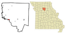 Location of Brunswick, Missouri | |
| Coordinates: 39°25′25″N 93°7′44″W / 39.42361°N 93.12889°WCoordinates: 39°25′25″N 93°7′44″W / 39.42361°N 93.12889°W | |
| Country | United States |
| State | Missouri |
| County | Chariton |
| Area[1] | |
| • Total | 1.25 sq mi (3.24 km2) |
| • Land | 1.20 sq mi (3.11 km2) |
| • Water | 0.05 sq mi (0.13 km2) |
| Elevation | 650 ft (198 m) |
| Population (2010)[2] | |
| • Total | 858 |
| • Estimate (2012[3]) | 838 |
| • Density | 715.0/sq mi (276.1/km2) |
| Time zone | Central (CST) (UTC-6) |
| • Summer (DST) | CDT (UTC-5) |
| ZIP code | 65236 |
| Area code(s) | 660 |
| FIPS code | 29-09046[4] |
| GNIS feature ID | 0714816[5] |
Brunswick is a rural city in Chariton County, Missouri, United States. The population was 858 at the 2010 census. Brunswick, by official state proclamation, is the Pecan Capital of Missouri.[6] The Missouri Farmers Association (MFA Incorporated) was founded in Brunswick in 1914.
History
For thousands of years varying cultures of indigenous peoples settled by the Missouri River. At the time of European contact, historical tribes in the area included the Missouri, Osage, Kaw, Otoe and others. In 1723 Etienne de Veniard, Sieur de Bourgmont built Fort Orleans near here, established on the Missouri River near the mouth of the Grand River. It was occupied 1723-1726 as the first multi-year European fort and settlement in present-day Missouri. It was to be a trading centerpiece of La Louisiane, the new territory claimed by the French.
Following the Louisiana Purchase and the end of the French colonial period the area saw a large influx of immigrants from the U.S., especially Kentucky and Tennessee. They brought African-American slaves and slaveholding traditions with them. The new land owners planted and cultivate crops similar to those in the Upper South: hemp and tobacco. Chariton was one of several counties along the Missouri River to become known as Little Dixie.[7]
The original town of Brunswick was laid out in 1836 by James Keyte. Keyte, an English immigrant and Methodist minister, was also the founder of Keytesville, Missouri, the county seat of Chariton County.[8] It was named after Brunswick, in England.[9] The original town plat was about 500 yards south of its current location, but due to changes in the Missouri and Grand Rivers the location is now underwater. Mr. Keyte established the first store in the town, and its first industry, a sawmill. Early growth was slow for the community with the population estimated at around 125 citizens by 1840. However in the early 1840s a large influx of new residents increased the size of the town and scope of business offerings. They would include a hotel, a wagon maker, brick factory, and a pork packing facility. Doctor Edwin Price, brother of famed Confederate general Sterling Price, was an early settler.[8] In the decades leading up to the American Civil War surrounding counties had no railroad over which to ship or receive goods and crops, thus Brunswick with its steamboat access, became a regional trading center. In 1849 Brunswick recorded 534 arrivals and departures by steamboats. The first school was established at Brunswick in June, 1840 with approximately thirty-five students and a one-room log schoolhouse. It was also in 1840 that the first wave of German immigrants arrived in the Brunswick area. Another influx of Germans took place in 1842. The Brunswicker, the towns first newspaper, began publication in October, 1847 and continues today, making it one of the state's oldest.[10] Brunswick's first bank, a branch of the Merchants Bank of St. Louis, opened.[6] After the Civil War and the loss of their slaves, farmers shifted to other less labor-intensive, crops. However in 1880 Chariton County still led the state of Missouri in tobacco production, with 14 million pounds harvested. After nearly ten years of delay due to the war, the railroad finally reached Brunswick in 1867, reducing the reliance on steamboats to transport goods and people.[10]
Dr. W.W. Bowen established the Brunswick Institute of Pharmacy in 1910. The school would train more than 5,000 pharmacists and druggists before closing in 1937.[10] In 1914, farmers organized the Missouri Farmers Association (MFA), a cooperative, based in Brunswick. It has since moved to Columbia, Missouri. Brunswick saw a growth of industry through the mid-20th century, with the construction of an alfalfa drying plant constructed in 1939, the Chariton Electric Company in 1958, in 1965 the opening of the Tuloma Fertilizer blending plant, and in 1970 the establishment of a glove factory. Also in 1965 the U.S. Coast Guard built a small base near Brunswick to service increased river traffic, however the facility was relatively short-lived, closing in March 1973.[6]
Following World War II, Brunswick became the center of an area of pecan groves. In 1972 State Representative Creason secured a state proclamation naming Brunswick the Pecan Capital of Missouri.[6] The Brunswick Pecan Festival was first held in 1980, celebrating the large number of pecans being harvested in the area. It would become an annual tradition that continues each October. The world's largest 20th-century pecan—a concrete replica—is located along Highway 24 in downtown Brunswick. It measures seven by twelve feet and weighs twelve thousand pounds. It was constructed in 1982 by George James in honor of the Starking Hardy Giant pecan, which he discovered on his property in 1947.[11]
Locust Hill was listed on the National Register of Historic Places in 1980.[12]
Education
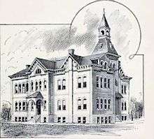
Schools in the Brunswick area date back to 1840, when a small one-room log "subscription" or private school was constructed. Following the Civil War, attention turned more toward public education, with the first public school opening in the town circa 1868.[13] A large three-story brick school was constructed in 1871 and served the community well into the early 20th century, being replaced by a new school in 1930-31. The present junior high / high school building used by Brunswick R-II school district was constructed in 1956-57. The most recent addition to the facilities is a new grade school constructed in 1991-1992.[6] In 1949 Missouri reorganized public education, with the state board of education consolidating or reorganizing many small rural schools into larger districts, this gave birth to the aforementioned Brunswick R-II district. The district, in student count, is the second largest in Chariton County, trailing Salisbury schools. Enrollment in all grades from 2006 to 2010 averaged 250 students.[14] The school colors are red and black. Their mascot is the Wildcat. Brunswick R-II participates in sports and other activities as a Class 1A school under guidelines from the Missouri State High School Activities Association.
Notable people
- Darold Knowles -- Former MLB relief pitcher. First pitcher to ever appear in all seven games of a World Series. The baseball field at Brunswick R-II school is named in his honor.
- Wayne E. Meyer -- U.S. Navy admiral, "Father of the Aegis weapons system".
- W. James Morgan—Union Army officer, responsible for the Burning of Platte City during the American Civil War.
- Sol Smith Russell -- Comic stage actor of the late 19th century. Russell Opera House in Brunswick is named for him.
- Wilbur Sweatman -- Ragtime and Dixieland jazz composer and performer.
Geography
Brunswick is located at 39°25′25″N 93°7′44″W / 39.42361°N 93.12889°W (39.423563, -93.128819).[15]
According to the United States Census Bureau, the city has a total area of 1.25 square miles (3.24 km2), of which 1.20 square miles (3.11 km2) is land and 0.05 square miles (0.13 km2) is water.[1]
Demographics
| Historical population | |||
|---|---|---|---|
| Census | Pop. | %± | |
| 1850 | 363 | — | |
| 1870 | 1,645 | — | |
| 1880 | 1,801 | 9.5% | |
| 1890 | 1,748 | −2.9% | |
| 1900 | 1,403 | −19.7% | |
| 1910 | 1,606 | 14.5% | |
| 1920 | 1,411 | −12.1% | |
| 1930 | 1,715 | 21.5% | |
| 1940 | 1,749 | 2.0% | |
| 1950 | 1,653 | −5.5% | |
| 1960 | 1,493 | −9.7% | |
| 1970 | 1,370 | −8.2% | |
| 1980 | 1,272 | −7.2% | |
| 1990 | 1,074 | −15.6% | |
| 2000 | 925 | −13.9% | |
| 2010 | 858 | −7.2% | |
| Est. 2015 | 830 | [16] | −3.3% |
2010 census
As of the census[2] of 2010, there were 858 people, 379 households, and 223 families residing in the city. The population density was 715.0 inhabitants per square mile (276.1/km2). There were 491 housing units at an average density of 409.2 per square mile (158.0/km2). The racial makeup of the city was 88.8% White, 9.1% African American, 0.1% Native American, 0.1% from other races, and 1.9% from two or more races. Hispanic or Latino of any race were 0.2% of the population.
There were 379 households of which 25.3% had children under the age of 18 living with them, 40.1% were married couples living together, 14.5% had a female householder with no husband present, 4.2% had a male householder with no wife present, and 41.2% were non-families. 37.2% of all households were made up of individuals and 20% had someone living alone who was 65 years of age or older. The average household size was 2.16 and the average family size was 2.77.
The median age in the city was 47.7 years. 22.5% of residents were under the age of 18; 6.9% were between the ages of 18 and 24; 17.9% were from 25 to 44; 25.2% were from 45 to 64; and 27.4% were 65 years of age or older. The gender makeup of the city was 48.0% male and 52.0% female.
2000 census
As of the census[4] of 2000, there were 925 people, 426 households, and 242 families residing in the city. The population density was 776.8 people per square mile (300.1/km²). There were 536 housing units at an average density of 450.1 per square mile (173.9/km²). The racial makeup of the city was 86.16% White, 13.30% African American, 0.32% from other races, and 0.22% from two or more races. Hispanic or Latino of any race were 0.86% of the population.
There were 426 households out of which 20.9% had children under the age of 18 living with them, 44.6% were married couples living together, 9.4% had a female householder with no husband present, and 43.0% were non-families. 39.0% of all households were made up of individuals and 26.3% had someone living alone who was 65 years of age or older. The average household size was 2.09 and the average family size was 2.74.
In the city the population was spread out with 21.2% under the age of 18, 6.2% from 18 to 24, 22.5% from 25 to 44, 22.3% from 45 to 64, and 27.9% who were 65 years of age or older. The median age was 45 years. For every 100 females there were 82.8 males. For every 100 females age 18 and over, there were 80.4 males.
The median income for a household in the city was $27,969, and the median income for a family was $34,107. Males had a median income of $27,639 versus $18,182 for females. The per capita income for the city was $18,516. About 11.3% of families and 17.7% of the population were below the poverty line, including 15.9% of those under age 18 and 19.8% of those age 65 or over.
References
- 1 2 "US Gazetteer files 2010". United States Census Bureau. Archived from the original on 2012-07-14. Retrieved 2012-07-08.
- 1 2 "American FactFinder". United States Census Bureau. Retrieved 2012-07-08.
- ↑ "Population Estimates". United States Census Bureau. Archived from the original on 2013-06-17. Retrieved 2013-05-30.
- 1 2 "American FactFinder". United States Census Bureau. Archived from the original on 2013-09-11. Retrieved 2008-01-31.
- ↑ "US Board on Geographic Names". United States Geological Survey. 2007-10-25. Retrieved 2008-01-31.
- 1 2 3 4 5 "Brunswick Timeline" (PDF). Brunswick Area Chamber of Commerce. 2012. Retrieved 11 August 2012.
- ↑ "The Story of Little Dixie, Missouri". Missouri Division - Sons of Confederate Veterans. 2001. Retrieved 3 June 2008.
- 1 2 Historical, Pictorial, & Biographical Record of Chariton County, Missouri, Pictorial and Biographical Publishing Co., Salisbury Missouri, 1896
- ↑ Ramsay, Robert L. (1952). Our Storehouse of Missouri Place Names. University of Missouri Press. p. 29.
- 1 2 3 "Brunswick history". Brunswick Area Chamber of Commerce. 2012. Retrieved 11 August 2012.
- ↑ "Worlds Largest 20th Century Pecan.". Roadside America.com travel website. 2012. Retrieved 7 August 2012.
- ↑ National Park Service (2010-07-09). "National Register Information System". National Register of Historic Places. National Park Service.
- ↑ "Brunswick school history" (PDF). Brunswick Area Chamber of Commerce. 2012. Retrieved 10 August 2012.
- ↑ "Chariton County school districts data" (PDF). Keytesville Chamber of Commerce. 2011. Retrieved 5 August 2012.
- ↑ "US Gazetteer files: 2010, 2000, and 1990". United States Census Bureau. 2011-02-12. Retrieved 2011-04-23.
- ↑ "Annual Estimates of the Resident Population for Incorporated Places: April 1, 2010 to July 1, 2015". Retrieved July 2, 2016.
- ↑ "Census of Population and Housing". Census.gov. Archived from the original on May 11, 2015. Retrieved June 4, 2015.
External links
- Historic maps of Brunswick in the Sanborn Maps of Missouri Collection at the University of Missouri
- Brunswick Missouri Website - http://www.brunswickmo.com
Municipalities and communities of Chariton County, Missouri, United States | ||
|---|---|---|
| Cities | 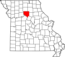 | |
| Villages | ||
| Townships | ||
| Unincorporated communities | ||
| Footnotes | ‡This populated place also has portions in an adjacent county or counties | |