Budelière
| Budelière | |
|---|---|
|
The church in Budelière | |
 Budelière | |
|
Location within Nouvelle-Aquitaine region  Budelière | |
| Coordinates: 46°13′15″N 2°28′09″E / 46.2208°N 2.4692°ECoordinates: 46°13′15″N 2°28′09″E / 46.2208°N 2.4692°E | |
| Country | France |
| Region | Nouvelle-Aquitaine |
| Department | Creuse |
| Arrondissement | Aubusson |
| Canton | Chambon-sur-Voueize |
| Intercommunality | Évaux-les-Bains Chambon-sur-Voueize |
| Government | |
| • Mayor (2008–2014) | Jacques Constantin |
| Area1 | 25.07 km2 (9.68 sq mi) |
| Population (2008)2 | 793 |
| • Density | 32/km2 (82/sq mi) |
| Time zone | CET (UTC+1) |
| • Summer (DST) | CEST (UTC+2) |
| INSEE/Postal code | 23035 / 23170 |
| Elevation | 293–449 m (961–1,473 ft) |
|
1 French Land Register data, which excludes lakes, ponds, glaciers > 1 km² (0.386 sq mi or 247 acres) and river estuaries. 2 Population without double counting: residents of multiple communes (e.g., students and military personnel) only counted once. | |

Budelière is a commune in the Creuse department in the Nouvelle-Aquitaine region in central France.
Geography
An area of lakes, forestry and farming comprising the village and several hamlets situated some 10 miles (16 km) southwest of Montlucon at the junction of the D993 and the D64 roads.
Between 1905 and 1955, the commune had a goldmine at Le Chatelet, which produced 11 tonnes of gold in those years.
The commune is served by a TER railway.
The river Tardes forms all of the commune's eastern border, then flows into the Cher, 4 km (2.5 mi) northwest of the village.
Population
| Historical population | ||
|---|---|---|
| Year | Pop. | ±% |
| 1962 | 636 | — |
| 1968 | 689 | +8.3% |
| 1975 | 623 | −9.6% |
| 1982 | 715 | +14.8% |
| 1990 | 756 | +5.7% |
| 1999 | 755 | −0.1% |
| 2008 | 793 | +5.0% |
Sights
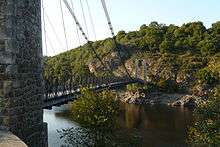
Suspension bridge over the Tardes, between Budelière and Évaux-les-Bains
- The church, dating from the nineteenth century.
- The church at St.Radegonde, dating from the twelfth century.
- The church of St.Martial at Le Châtelet, dating from the twelfth century.
- The château de la Villederie.
- The chapel of Saint-Marien.
See also
References
External links
| Wikimedia Commons has media related to Budelière. |
- Official website of the commune of Budelière (French)
- Budelière on the Quid website (French)
This article is issued from Wikipedia - version of the 11/11/2016. The text is available under the Creative Commons Attribution/Share Alike but additional terms may apply for the media files.