Bussière-Dunoise
| Bussière-Dunoise | |
|---|---|
|
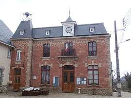
The town hall in Bussière-Dunoise | |
 Bussière-Dunoise | |
|
Location within Nouvelle-Aquitaine region  Bussière-Dunoise | |
| Coordinates: 46°15′35″N 1°45′48″E / 46.2597°N 1.7633°ECoordinates: 46°15′35″N 1°45′48″E / 46.2597°N 1.7633°E | |
| Country | France |
| Region | Nouvelle-Aquitaine |
| Department | Creuse |
| Arrondissement | Guéret |
| Canton | Saint-Vaury |
| Intercommunality | Guéret Saint-Vaury |
| Government | |
| • Mayor (2008–2014) | Jean-Pierre Grimaud |
| Area1 | 41.13 km2 (15.88 sq mi) |
| Population (2008)2 | 1,105 |
| • Density | 27/km2 (70/sq mi) |
| Time zone | CET (UTC+1) |
| • Summer (DST) | CEST (UTC+2) |
| INSEE/Postal code | 23036 / 23320 |
| Elevation |
324–615 m (1,063–2,018 ft) (avg. 415 m or 1,362 ft) |
|
1 French Land Register data, which excludes lakes, ponds, glaciers > 1 km² (0.386 sq mi or 247 acres) and river estuaries. 2 Population without double counting: residents of multiple communes (e.g., students and military personnel) only counted once. | |
Bussière-Dunoise is a commune in the Creuse department in the Nouvelle-Aquitaine region in central France.
Geography
An area of forestry and farming comprising the village and several hamlets situated some 8 miles (13 km) northwest of Guéret, at the junction of the D14, D47 and the D22. Four small tributaries of the Creuse River have their source within the commune.
Population
| Historical population | ||
|---|---|---|
| Year | Pop. | ±% |
| 1962 | 1,306 | — |
| 1968 | 1,470 | +12.6% |
| 1975 | 1,329 | −9.6% |
| 1982 | 1,247 | −6.2% |
| 1990 | 1,139 | −8.7% |
| 1999 | 1,098 | −3.6% |
| 2008 | 1,105 | +0.6% |
Sights
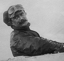
Jules Védrines
- The church of St. Symphorien, dating from the twelfth century.
- A memorial in stone, to French aviator, Jules Védrines, whose wife was born here.
See also
References
External links
| Wikimedia Commons has media related to Bussière-Dunoise. |
- Bussière-Dunoise on the Quid website (French)
This article is issued from Wikipedia - version of the 11/11/2016. The text is available under the Creative Commons Attribution/Share Alike but additional terms may apply for the media files.