Bula, Texas
| Bula, Texas | |
|---|---|
| Unincorporated community | |
|
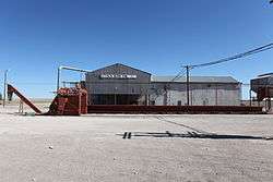
Abandoned cotton gin in Bula | |
 Bula  Bula | |
| Coordinates: 33°54′41″N 102°38′17″W / 33.91139°N 102.63806°WCoordinates: 33°54′41″N 102°38′17″W / 33.91139°N 102.63806°W | |
| Country |
|
| State |
|
| County | Bailey |
| Physiographic region | Llano Estacado |
| Founded | 1924 |
| Elevation[1] | 3,793 ft (1,156 m) |
| Time zone | Central (CST) (UTC-6) |
| • Summer (DST) | CDT (UTC-5) |
| ZIP code | 79324 |
| Area code | 806 |
| Website | Handbook of Texas |
Bula (/ˈbjuːlə/ BYOO-la[2]) is an unincorporated community in Bailey County, Texas, United States.
History
The community of Bula was established in 1924 and originally given the name Newsome. Due to a conflict with another Texas post office with the same name, the name was changed to Bula in 1925.[3] Bula had a school in 1925 and a cotton gin in 1929 but never grew significantly. By 1980 the population had risen to only 105 then dropped to thirty-five in 2000.[3]
Geography
Bula is located on the level plains of the Llano Estacado in the southeast corner of Bailey County, approximately 22 miles (35 km) southeast of the county seat of Muleshoe, and 7 miles (11 km) east of the Muleshoe National Wildlife Refuge. It is located on Farm to Market Road 54 to the west of Littlefield, the county seat of Lamb County.
See also
References
- ↑ "Bula". Geographic Names Information System. United States Geological Survey.
- ↑ "Texas Tripper". Say it like a Texan. Retrieved 2013-02-07.
- 1 2 Hunt, William R. "Bula, TX (Bailey County)". Handbook of Texas Online. Retrieved 2011-04-27.
External links
- U.S. Geological Survey Geographic Names Information System: Bula, Texas
- Public domain photos of the Llano Estacado
Municipalities and communities of Bailey County, Texas, United States | ||
|---|---|---|
| City | 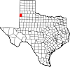 | |
| Unincorporated communities | ||
| Ghost town | ||