Burrewarra Point Light
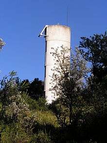 Burrewarra Point Light. The solar panel can be seen on the top left of the tower. | |
 New South Wales | |
| Location |
Burrewarra Point New South Wales |
|---|---|
| Coordinates | 35°50′1.93″S 150°14′1.11″E / 35.8338694°S 150.2336417°ECoordinates: 35°50′1.93″S 150°14′1.11″E / 35.8338694°S 150.2336417°E |
| Year first constructed | 1974 |
| Automated | 1974 |
| Construction | concrete tower |
| Tower shape | elliptical cylindrical tower and no lantern |
| Markings / pattern | white tower |
| Height | 33 feet (10 m)[1] |
| Focal height | 203 feet (62 m) |
| Light source | solar power |
| Range | 9 nautical miles (17 km) |
| Characteristic | Fl (4) W 15s. |
| Admiralty number | K2577.6 |
| NGA number | 111-6556 |
| ARLHS number | AUS-016 |
| Managing agent | Australian Maritime Safety Authority |
Burrewarra Point Light is an active lighthouse located at Burrewarra Point, New South Wales, Australia, which is north of Broulee and 25 kilometres (16 mi) to the south of Batemans Bay.
The light was constructed in 1974 as an automated lighthouse which was powered from batteries charged from the mains. In 1984 it was converted to solar power, with battery backup.[2]
The light has no lantern.[3]
Site operation and visiting
The lighthouse is operated by Roads and Maritime Services (formerly NSW Maritime).[4] The site is open and accessible to the public, but the tower is closed.[3]
See also
Notes
- ↑ According to all sources except Searle, which has it at 10 feet (3.0 m), most likely a unit conversion error.
- ↑ Lighthouses of Australia Inc.
- 1 2 Rowlett.
- ↑ NSW Maritime though Rowlett says Australian Maritime Safety Authority.
References
- List of Lights, Pub. 111, The West Coasts of North and South America (Excluding Continental U.S.A. and Hawaii), Australia, Tasmania, New Zealand, and the Islands of the North and South Pacific Oceans (PDF). List of Lights. United States National Geospatial-Intelligence Agency. 2009. p. 133.
- Rowlett, Russ. "Lighthouses of Australia: New South Wales". The Lighthouse Directory. University of North Carolina at Chapel Hill. Retrieved 2010-08-29.
- "The Burrewarra Point Lighthouse near Batemans Bay". Lighthouses of New South Wales. Lighthouses of Australia Inc.
- Searle, Garry. "List of Lighthouses - New South Wales". Lighthouses of Australia. SeaSide Lights.
- "Lighthouse Lights - NSW Maritime". maritime.nsw.gov.au. Retrieved 3 October 2010.
External links
| Wikimedia Commons has media related to Burrewarra Point Lighthouse. |
| North Coast |  | |
|---|---|---|
| Outside Sydney Harbour | ||
| Inside Sydney Harbour | ||
| South Coast | ||
This article is issued from Wikipedia - version of the 7/7/2016. The text is available under the Creative Commons Attribution/Share Alike but additional terms may apply for the media files.