Richmond River Light
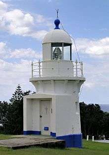 Richmond River Light, 2006 | |
 New South Wales | |
| Location |
Ballina New South Wales Australia |
|---|---|
| Coordinates | 28°52′1.31″S 153°35′30.49″E / 28.8670306°S 153.5918028°ECoordinates: 28°52′1.31″S 153°35′30.49″E / 28.8670306°S 153.5918028°E |
| Year first constructed | 1866 |
| Year first lit | 1880[1] |
| Automated | 1920[2] |
| Construction | stone tower[3] |
| Tower shape | cylindrical tower with balcony and lantern |
| Markings / pattern | white tower and lantern |
| Height | 25 feet (7.6 m)[4] |
| Focal height | 115 feet (35 m) |
| Original lens | 4th order catadioptric |
| Current lens | 2nd order Chance Brothers Fresnel lens[5] |
| Light source | mains power |
| Intensity | 28,000 cd |
| Range | 14 nautical miles (26 km; 16 mi)[6] |
| Characteristic | Fl (4) W 16s. |
| Admiralty number | K2834 |
| NGA number | 111-5888 |
| ARLHS number | AUS-142 |
| Managing agent | NSW Maritime |
Richmond River Light, also known as Ballina Head Light and Ballina Light, is an active lighthouse located at Ballina Head, a headland in Ballina, New South Wales, Australia. The headland is at the northern side of the entrance to the Richmond River. It used to serve to guide ships into the river port and is used also serves as a leading light into the river, together with a steamer's masthead lantern with a 200 mm lens which is raised on a wooden structure 30 metres (98 ft) from it.[7]
History
The station was established with a temporary light that was installed in 1866 from plans by James Barnet, at the same time of the installation of the Clarence River Light.[8][7]
The current lighthouse is one of five lighthouses of similar design designed and built by James Barnet in 1878-80, the other four being Fingal Head Light, Clarence River Light (now demolished), Tacking Point Lighthouse and Crowdy Head Light. A tender was called in 1878, it was built in 1879 and lit in 1880.[8]
The apparatus was a fixed light 4th order catadioptric apparatus of less than 1000 cd and was visible for 12 nautical miles (22 km; 14 mi).[9] It was powered by colza oil.[8] As the light was operated in conjunction with a nearby pilot station, only one light keeper was required.[7]
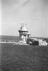
In 1920 the light was converted to acetylene gas and automated. [8] In November 1940, the annexe and the porch connected to the lighthouse were demolished.[10]
The light was electrified in the 1960s. The current light source is a 28,000 cd, 1,000 Watt 120 Volt tungsten-halogen lamp, and the power source is the Mains with a Battery standby.[8] It shows a light characteristic of four white flashes every 16 s (Fl.(4)W. 16s)[11]
Structure
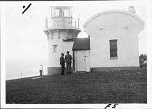
The tower is very similar in design to the other four lighthouses.[7] It is circular, 6 feet (1.8 m) in diameter (internally), with walls tapering from 19 inches (480 mm) at the bottom to 14 inches (360 mm) at the top.[7] The tower is constructed of stone,[3] and cement rendered, and painted white.[7] On top of the tower there is an oversailing bluestone platform, supported at by twelve bluestone corbels, at about 12 feet (3.7 m) above the ground. The platform can be reached by an iron stair inside the tower. Around the perimeter of the platform is a metal handrail. The platform is topped by the simple metal dome which houses the optical apparatus.[7]
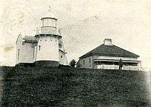
Originally the lighthouse had a porch, rectangular annexe for the duty room and oil store. These were all demolished in November 1940.[10] A one story keeper's house is still present at the premises.[12]
Site operation
The light is currently operated by Roads and Maritime Services (formerly NSW Maritime)[13] and the site is managed by the New South Wales Department of Lands.[12]
Visiting
The site is open to the public and accessible, but the tower is closed.[12]
See also
Notes
- ↑ According to all sources. Though NSW Maritime says 1879 in one column, it says 1880 in the text.
- ↑ According to Lighthouses of Australia Inc. RNE208 says 1926.
- 1 2 According to Rowlett and "Masonry" in Lighthouses of Australia Inc. RNE208 says "brick tower", perhaps referring to "stone bricks", the form, rather than the material.
- ↑ According to most sources. A table at Searle lists 64 feet (20 m), most likely a mistake as the text lists 25 ft. NSW Maritime says 7m.
- ↑ According to Rowlett and the body text of Lighthouses of Australia Inc. A table on Lighthouses of Australia Inc states a 4th order lens, maybe referring to the original lens.
- ↑ According to the List of Lights. According to Lighthouses of Australia Inc and NSW Maritime it is 17 nm.
- 1 2 3 4 5 6 7 RNE208.
- 1 2 3 4 5 Lighthouses of Australia Inc.
- ↑ According to Lighthouses of Australia Inc. RNE208 says 19 km.
- 1 2 Though RNE208 says the demolition occurred when the light was converted to electricity, which Lighthouses of Australia Inc puts in the 1960s, Demolition has a picture of the demolition itself, taking place in November 1940
- ↑ List of Lights
- 1 2 3 Rowlett.
- ↑ According to NSW Maritime, though Rowlett says New South Wales Maritime Authority.
References
| Wikimedia Commons has media related to Ballina Lighthouse. |
- List of Lights, Pub. 111, The West Coasts of North and South America (Excluding Continental U.S.A. and Hawaii), Australia, Tasmania, New Zealand, and the Islands of the North and South Pacific Oceans (PDF). List of Lights. United States National Geospatial-Intelligence Agency. 2009. p. 121.
- Rowlett, Russ. "Lighthouses of Australia: New South Wales". The Lighthouse Directory. University of North Carolina at Chapel Hill. Retrieved 2010-08-29.
- "The Richmond River Lighthouse". Lighthouses of New South Wales. Lighthouses of Australia Inc.
- "Richmond River Lighthouse (listing RNE208)". Australia Heritage Places Inventory. Department of Sustainability, Environment, Water, Population and Communities.
- "Lighthouse Lights - NSW Maritime". maritime.nsw.gov.au. Retrieved 3 October 2010.
- Searle, Garry. "Ballina Head". Lighthouses of New South Wales. SeaSide Lights. Seems to be based on the same source of RNE208, except for some discrepancies.
- "Richmond River lighthouse during demolition (photographic image)". National Archives of Australia. November 1940.
| North Coast | 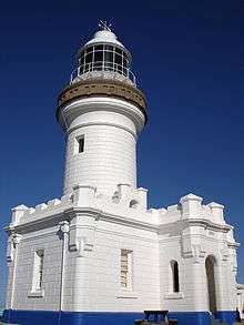 | |
|---|---|---|
| Outside Sydney Harbour | ||
| Inside Sydney Harbour | ||
| South Coast | ||