California Historical Landmarks in Ventura County, California
For more on the first recorded European land entry and exploration of this area, see
Portolà expedition.
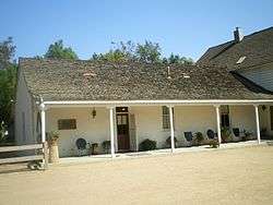
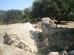
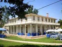
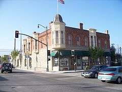
This list includes properties and districts listed on the California Historical Landmark listing in Ventura County, California. Click the "Map of all coordinates" link to the right to view a Google map of all properties and districts with latitude and longitude coordinates in the table below.
See also
References
|
|---|
|
| |
|---|
| | National Parks | |
|---|
| | National Preserves | |
|---|
| | National Monuments | |
|---|
| | National Seashores | |
|---|
| | National Historical Parks | |
|---|
| | National Historic Sites | |
|---|
| | National Memorials | |
|---|
| | National Recreation Areas | |
|---|
|
|
|
| |
|---|
| | State Parks | |
|---|
| State
Natural Reserves | |
|---|
| State
Marine Reserves | |
|---|
| State
Historic Parks | |
|---|
| | State Beaches | |
|---|
| State
Recreation Areas | |
|---|
| State Vehicular
Recreation Areas |
- Carnegie
- Clay Pit
- Heber Dunes
- Hollister Hills
- Hungry Valley
- Oceano Dunes
- Ocotillo Wells
- Prairie City
|
|---|
| | Other | |
|---|
|
|
|
| |
|---|
| National Forests
and Grasslands | |
|---|
| National Wilderness
Preservation System | |
|---|
| National Monuments
and Recreation Areas | |
|---|
|
|
|
|
|
|
|
| |
|---|
| Wildlife
Areas | |
|---|
| Ecological
Reserves |
- Albany Mudflats
- Alkali Sink
- Allensworth
- Atascadero Creek Marsh
- Bair Island
- Baldwin Lake
- Batiquitos Lagoon
- Blue Sky
- Boden Canyon
- Boggs Lake
- Bolsa Chica
- Bonny Doon
- Buena Vista Lagoon
- Butler Slough
- Butte Creek Canyon
- Butte Creek House
- Buttonwillow
- By Day Creek
- Calhoun Cut
- Canebrake
- Carlsbad Highlands
- Carmel Bay
- Carrizo Canyon
- Carrizo Plains
- China Point
- Clover Creek
- Coachella Valley
- Coal Canyon
- Corte Madera Marsh
- Crestridge
- Dairy Mart Ponds
- Dales Lake
- Del Mar Landing
- Eden Landing
- Elkhorn Slough
- Estelle Mountain
- Fall River Mills
- Fish Slough
- Fremont Valley
- Goleta Slough
- Indian Joe Spring
- Kaweah
- Kerman
- King Clone
- Laguna Laurel
- Loch Lomond Vernal Pool
- Lokern
- Magnesia Spring
- Marin Islands
- Mattole River
- McGinty Mountain
- Morro Dunes
- Morro Rock
- Napa River
- North Table Mountain
- Oasis Spring
- Panoche Hills
- Peytonia Slough
- Pine Hill
- Piute Creek
- Pleasant Valley
- Rancho Jamul
- Redwood Shores
- River Springs Lakes
- Saline Valley
- San Dieguito Lagoon
- San Elijo Lagoon
- San Felipe Creek
- San Joaquin River
- Santa Rosa Plateau
- Springville
- Stone Corral
- Sycamore Canyon
- Sycuan Peak
- Thomes Creek
- Tomales Bay
- Upper Newport Bay
- Watsonville Slough
- West Mojave Desert
- Woodbridge
- Yaudanchi
|
|---|
| Marine
Protected
Areas | |
|---|
|
|
|
| |
|---|
| | National Monuments | |
|---|
| National
Conservation Areas | |
|---|
| | Wilderness Areas | |
|---|
|
|
|
|
|
|
|
|
|
|
.jpg)
.jpg)