Campbell County, Virginia
| Campbell County, Virginia | ||
|---|---|---|
|
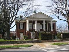
Campbell County Courthouse in Rustburg | ||
| ||
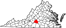 Location in the U.S. state of Virginia | ||
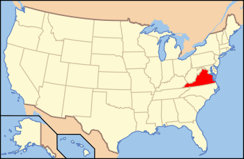 Virginia's location in the U.S. | ||
| Founded | 1782 | |
| Named for | General William Campbell | |
| Seat | Rustburg | |
| Largest town | Altavista | |
| Area | ||
| • Total | 507 sq mi (1,313 km2) | |
| • Land | 504 sq mi (1,305 km2) | |
| • Water | 3.5 sq mi (9 km2), 0.7% | |
| Population | ||
| • (2010) | 54,842 | |
| • Density | 109/sq mi (42/km²) | |
| Congressional district | 5th | |
| Time zone | Eastern: UTC-5/-4 | |
| Website |
www | |

Campbell County is a United States county situated in the south central part of the Commonwealth of Virginia. Located in the Piedmont region of Virginia, Campbell borders the Blue Ridge Mountains. The county seat is Rustburg.[1]
Grounded on a tobacco cash crop economy, Campbell County was created in 1782 from part of Bedford County. The county was named in honor of General William Campbell, hero of the American Revolutionary War.
Campbell County is part of the Lynchburg, VA Metropolitan Statistical Area. As of the 2010 census, the county population is 54,842. The number of residents has grown steadily in every census after 1930, and the total population has more than doubled since that time.[2]
History
The area that would become Campbell County was first settled by Europeans, initially Scotch-Irish Presbyterians, in the late 1730s. After nearly fifty years of immigration and development, the newly formed county was established in 1782 from part of Bedford County. Campbell County was named for Revolutionary War hero, General William Campbell, who is known for the 1780 Battle of Kings Mountain. The independent city of Lynchburg, Virginia was subsequently formed from the county in 1786.[4]
From its earliest days, the county relied on tobacco as the primary cash crop and basis for the economy, though it also developed early manufacturing operations. Brookneal, with its strategic location on the Staunton River, was long an important tobacco and textile hub. However, the departure of manufacturing and the changing tobacco market has forced Campbell to transform from a mainly agricultural area into a mixture of suburban and rural communities.[4]
Geography
According to the U.S. Census Bureau, the county has a total area of 507 square miles (1,313.1 km2), of which 504 square miles (1,305.4 km2) is land and 3 square miles (7.8 km2) (0.55%) is water.
Adjacent counties / Independent city
- Lynchburg, Virginia – northwest
- Amherst County, Virginia – north
- Appomattox County, Virginia – northeast
- Charlotte County, Virginia – east
- Halifax County, Virginia – southeast
- Pittsylvania County, Virginia – southwest
- Bedford County, Virginia – west
Major Highways
Demographics
| Historical population | |||
|---|---|---|---|
| Census | Pop. | %± | |
| 1790 | 7,685 | — | |
| 1800 | 9,866 | 28.4% | |
| 1810 | 11,001 | 11.5% | |
| 1820 | 16,569 | 50.6% | |
| 1830 | 20,350 | 22.8% | |
| 1840 | 21,030 | 3.3% | |
| 1850 | 23,245 | 10.5% | |
| 1860 | 26,197 | 12.7% | |
| 1870 | 28,384 | 8.3% | |
| 1880 | 36,250 | 27.7% | |
| 1890 | 41,087 | 13.3% | |
| 1900 | 23,256 | −43.4% | |
| 1910 | 23,043 | −0.9% | |
| 1920 | 26,716 | 15.9% | |
| 1930 | 22,885 | −14.3% | |
| 1940 | 26,048 | 13.8% | |
| 1950 | 28,877 | 10.9% | |
| 1960 | 32,958 | 14.1% | |
| 1970 | 43,319 | 31.4% | |
| 1980 | 45,424 | 4.9% | |
| 1990 | 47,572 | 4.7% | |
| 2000 | 51,078 | 7.4% | |
| 2010 | 54,842 | 7.4% | |
| Est. 2015 | 55,086 | [5] | 0.4% |
| U.S. Decennial Census[6] 1790–1960[7] 1900–1990[8] 1990–2000[9] 2010–2013[2] | |||
As of the census[10] of 2000, there were 51,078 people, 20,639 households, and 14,694 families residing in the county. The population density was 101 people per square mile (39/km²). There were 22,088 housing units at an average density of 44 per square mile (17/km²). The racial makeup of the county was 83.24% White, 14.71% Black or African American, 0.19% Native American, 0.62% Asian, 0.01% Pacific Islander, 0.33% from other races, and 0.90% from two or more races. 0.83% of the population were Hispanic or Latino of any race.
There were 20,639 households out of which 30.80% had children under the age of 18 living with them, 56.00% were married couples living together, 11.40% had a female householder with no husband present, and 28.80% were non-families. 24.60% of all households were made up of individuals and 8.80% had someone living alone who was 65 years of age or older. The average household size was 2.45 and the average family size was 2.91.
In the county, the population was spread out with 24.00% under the age of 18, 7.70% from 18 to 24, 29.30% from 25 to 44, 25.60% from 45 to 64, and 13.50% who were 65 years of age or older. The median age was 38 years. For every 100 females there were 95.30 males. For every 100 females age 18 and over, there were 92.30 males.
The median income for a household in the county was $37,280, and the median income for a family was $42,901. Males had a median income of $32,108 versus $22,286 for females. The per capita income for the county was $18,134. About 7.90% of families and 10.60% of the population were below the poverty line, including 14.10% of those under age 18 and 10.90% of those age 65 or over.
Government
Board of Supervisors
Altavista district: Mr. Stanley I. Goldsmith (I)
Brookneal district: Mr. James .D. (J.D.) Puckett (I)
Concord district: Mr. Eddie Gunter, Jr. (I)
Rustburg district: Mr. Eric R. Zehr (R)
Spring Hill district: Dr. James A. Borland (R)
Sunburst district: Mr. Robert Good (R)
Timberlake district: Mr. Michael P. Rousseau (R)
Constitutional Officers
Clerk of the Circuit Court: Sheila W. Bosiger
Commissioner of the Revenue: Calvin Massie (R)
Commonwealth's Attorney: Paul McAndrews (I)
Sheriff: Steve Hutcherson (I)
Treasurer: Robin Jefferson (R)
Campbell County is represented by Republicans Frank M. Ruff, Jr. and Stephen D. "Steve" Newman in the Virginia Senate, Republicans Kathy J. Byron, C. Matt Fariss, and James E. Edmunds, II in the Virginia House of Delegates, and Republican Robert Hurt in the U.S. House of Representatives.
Communities
Towns
Unincorporated communities
Sports and recreation
Campbell County is home to sporting events and organizations including:
- Altavista High School Sports
- Altavista YMCA
- Brookville Bees Youth Athletic Association - Nonprofit organization providing recreational Football and Basketball for area youth.
- Brookville High School Sports
- Brookville Soccer Club - Nonprofit organization providing recreational Soccer for area youth.
- Campbell County Parks & Recreation
- Hiking areas include Timbrook Park.
- Rustburg High School Sports
- Timber Lake - Fishing, Paddle boating, Swimming
- Timberlake Dixie Youth
- William Campbell High School Sports
See also
- National Register of Historic Places listings in Campbell County, Virginia
- Campbell County Public Schools (Virginia)
References
- ↑ "Find a County". National Association of Counties. Archived from the original on 2011-05-31. Retrieved 2011-06-07.
- 1 2 "State & County QuickFacts". United States Census Bureau. Retrieved January 1, 2014.
- ↑ http://www.loc.gov/pictures/collection/hh/item/va0274.photos.160023p/
- 1 2 "About Campbell County". Campbell County, Virginia. Retrieved 9 February 2015.
- ↑ "County Totals Dataset: Population, Population Change and Estimated Components of Population Change: April 1, 2010 to July 1, 2015". Retrieved July 2, 2016.
- ↑ "U.S. Decennial Census". United States Census Bureau. Archived from the original on May 11, 2015. Retrieved January 1, 2014.
- ↑ "Historical Census Browser". University of Virginia Library. Retrieved January 1, 2014.
- ↑ "Population of Counties by Decennial Census: 1900 to 1990". United States Census Bureau. Retrieved January 1, 2014.
- ↑ "Census 2000 PHC-T-4. Ranking Tables for Counties: 1990 and 2000" (PDF). United States Census Bureau. Retrieved January 1, 2014.
- ↑ "American FactFinder". United States Census Bureau. Archived from the original on 2013-09-11. Retrieved 2011-05-14.
 |
City of Lynchburg and Amherst County | Appomattox County | | |
| Bedford County | |
Charlotte County | ||
| ||||
| | ||||
| Pittsylvania County | Halifax County |
Municipalities and communities of Campbell County, Virginia, United States | ||
|---|---|---|
| Towns | | |
| CDPs | ||
| Unincorporated communities | ||
| Footnotes | ‡This populated place also has portions in an adjacent county or counties | |
Coordinates: 37°13′N 79°05′W / 37.21°N 79.09°W