Mecklenburg County, Virginia
| Mecklenburg County, Virginia | ||
|---|---|---|
|
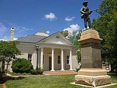
Mecklenburg County Courthouse | ||
| ||
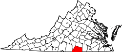 Location in the U.S. state of Virginia | ||
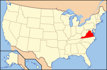 Virginia's location in the U.S. | ||
| Founded | 1765 | |
| Named for | Charlotte of Mecklenburg-Strelitz | |
| Seat | Boydton | |
| Largest town | South Hill | |
| Area | ||
| • Total | 679 sq mi (1,759 km2) | |
| • Land | 625 sq mi (1,619 km2) | |
| • Water | 54 sq mi (140 km2), 7.9% | |
| Population (est.) | ||
| • (2015) | 31,081 | |
| • Density | 46/sq mi (18/km²) | |
| Congressional district | 5th | |
| Time zone | Eastern: UTC-5/-4 | |
| Website |
www | |


Mecklenburg County is a county located in the Commonwealth of Virginia. As of the 2010 census, the population was 50,727.[1] Its county seat is Boydton.[2]
History
Mecklenburg County was organized on March 1, 1765, having split from Lunenburg County in 1764 as the result of the passage of an act by the Virginia General Assembly. Due to new settlement and population increases in the area, the legislature divided Lunenburg into three counties: Lunenburg, Charlotte, and Mecklenburg.[3] It was named after Queen Charlotte of Mecklenburg-Strelitz.[4]
The first county government consisted of 13 members; Robert Munford, Richard Witton, John Speed, Henry Delony, Edmund Taylor, Benjamin Baird, John Camp, Thomas Erskine, John Potter, John Cox, Thomas Anderson, John Speed, Jr., and Samuel Hopkins; with Benjamin Baird acting as the first mayor.[3]
Government
Mecklenburg County is governed by a 9-member Board of Supervisors, each elected from a single-member district. They serve as the legislating and policy body for the county enacting laws, ordinances, and taxes. They appoint a County Administrator to conduct day-to-day operations. H. Wayne Carter, III is the current County Administrator, Judy P. Sheffield is the current Assistant County Administrator.
The board members are:
- District 1 - Andy Hargrove
- District 2 - Glanzy M. Spain,Jr.,
- District 3 - Evans D. Tanner, Jr.,
- District 4 - Claudia Lundy
- District 5 - Glenn E. Barbour-Chair,
- District 6 - William E. Blalock,
- District 7 - James D. Jennings,
- District 8 - David A. Brankley,
- District 9 - Greg V. Gordon-Vice Chair
Constitutional officers
Under the Virginia Constitution, each county and city within the state must install Constitutional Officers. Counties under the Traditional Form of Government must install all five officers. The majority of Virginia counties operate under the Traditional Form. Counties with the County Executive Form, Urban County Executive, or County Manager Plan of Government usually install just three (Clerk, Commonwealth Attorney, and Sheriff) opting for a Director of Finance appointed by the Board to take the place of the Commissioner of Revenue and Treasurer. Examples are (Fairfax, Henrico and Prince William Counties). These officers are heads of their respective departments. They consist of:
- Clerk of Circuit Court - responsible for all circuit court records civil and criminal, along with all deeds, wills, plats and other records.
- Commonwealth's Attorney - responsible to represent the Commonwealth of Virginia in Mecklenburg County Court in all cases, chief prosecuting officer for their jurisdiction.
- Commissioner of Revenue - chief assessor of all real estate and personal property within the county and recommends a tax rate to the Board of Supervisors and maintains accurate real estate records for the Land Book.
- Treasurer - manages all finances within the county,helps prepare the budget for submission to the Board, and is responsible for the collection of all taxes.
- Sheriff - Chief law enforcement officer for their jurisdiction.
Officers
- Clerk of Court - Edward E. Coleman, Jr.
- Commonwealth Attorney - Nora J. Miller
- Commissioner of Revenue - Joseph E.(Ed) Taylor
- Treasurer - Sandra P. Langford
- Sheriff - Robert (Bobby) Hawkins
Education
The county's education department is called the Mecklenburg County Public Schools. It is currently managed by the Board of Education. It seats Dr. James Thornton as the County Schools Superintendent.
Government and infrastructure
County departments and department heads
Listed below are the County facilities, the department housed in that facility and its head.
- Goode Bank Building
- Board of Supervisors (See Supervisor's List Above)
- County Administrator's Office- H. Wayne Carter, III (Administrator)
- Economic Development Director's Office- Angela D. Kellett (Director)
- Tourism Office- Jacob P. Bower (Coordinator)
- Building Inspector's Office- Eddie Harris (Chief Inspector)
- Zoning Administrator's Office- Robert L. Hendrick (Zoning Administrator)
- Animal Warden's Office- Doug Blanton (Animal Warden)
- Courthouse
- Circuit Court-Leslie M. Osborn (Judge)
- Circuit Court Clerk's Office- E. E. Coleman, Jr. (Clerk)
- Commonwealth Attorney's Office- J. Miller (Commonwealth's Attorney)
- Mark I. Burnett Building
- Commissioner of Revenue's Office- Joseph E. Taylor (Commissioner)
- Real Estate Department-Lisa C. Wagstaff (Chief Deputy Commissioner/Real Estate Assessor)
- Personal Property Department-Joseph E. Taylor (Commissioner)
- Treasurer's Office- Sandra P. Langford (Treasurer)
- VPI Extension Office- C. Taylor Clarke (Unit Coordinator/ANR Extension Agent)
- Commissioner of Revenue's Office- Joseph E. Taylor (Commissioner)
- Hudgins Court Facility
- Social Services- Sandra S. Gregory (Director)
- General District Court- Charles Warren (Judge)
- General District Clerk's Office- Tammy T. Taylor (Clerk)
- Juvenile & Domestic Court- M. Rand (Judge), S. Anderson Nelson (Judge)
- J&D Court Clerk's Office- Rebecca D. Inge (Clerk)
- J&D Court Service Unit
- Sheriff's Office- R.W. (Bobby) Hawkins (Sheriff)
- 911 Center
- 911 Emergency Communications Office and Dispatch- Ben Duncan (Director)
- Jail
- Jail Division of the Sheriff's Office- Roosevelt Terry (Jail Captain)
- Post Office Building
- Piedmont Court Services- Jackie T. Boxley (Director)
- White Building
- Voter Registrar- Jason Corwin (General Registrar)
State representation
The Virginia Department of Corrections operates the Mecklenburg Correctional Center in unincorporated Mecklenburg County, near Boydton.[5] On August 3, 1998, the male death row moved to its current location, the Sussex I State Prison, from the Mecklenburg Correctional Center.[6]
Geography
According to the U.S. Census Bureau, the county has a total area of 679 square miles (1,760 km2), of which 625 square miles (1,620 km2) is land and 54 square miles (140 km2) (7.9%) is water.[7]
Adjacent counties
- Lunenburg County - north
- Brunswick County - east
- Warren County, North Carolina - southeast
- Vance County, North Carolina - south
- Granville County, North Carolina - southwest
- Halifax County - west
- Charlotte County - northwest
Major highways
Demographics
| Historical population | |||
|---|---|---|---|
| Census | Pop. | %± | |
| 1790 | 14,733 | — | |
| 1800 | 17,008 | 15.4% | |
| 1810 | 18,453 | 8.5% | |
| 1820 | 19,786 | 7.2% | |
| 1830 | 20,477 | 3.5% | |
| 1840 | 20,724 | 1.2% | |
| 1850 | 20,630 | −0.5% | |
| 1860 | 20,096 | −2.6% | |
| 1870 | 21,318 | 6.1% | |
| 1880 | 24,610 | 15.4% | |
| 1890 | 25,359 | 3.0% | |
| 1900 | 26,551 | 4.7% | |
| 1910 | 28,956 | 9.1% | |
| 1920 | 31,208 | 7.8% | |
| 1930 | 32,622 | 4.5% | |
| 1940 | 31,933 | −2.1% | |
| 1950 | 33,497 | 4.9% | |
| 1960 | 31,428 | −6.2% | |
| 1970 | 29,426 | −6.4% | |
| 1980 | 29,444 | 0.1% | |
| 1990 | 29,241 | −0.7% | |
| 2000 | 32,280 | 10.4% | |
| 2010 | 32,727 | 1.4% | |
| Est. 2015 | 31,081 | [8] | −5.0% |
| U.S. Decennial Census[9] 1790-1960[10] 1900-1990[11] 1990-2000[12] 2010-2013[1] | |||
As of the census[13] of 2010, there were 32,727 people, 12,951 households, and 8,962 families residing in the county. The population density was 52 people per square mile (20/km²). There were 17,403 housing units at an average density of 28 per square mile (11/km²). The racial makeup of the county was 59.24% White, 39.08% Black or African American, 0.21% Native American, 0.30% Asian, 0.01% Pacific Islander, 0.48% from other races, and 0.68% from two or more races. 1.21% of the population were Hispanic or Latino of any race.
There were 12,951 households out of which 26.50% had children under the age of 18 living with them, 51.00% were married couples living together, 14.10% had a female householder with no husband present, and 30.80% were non-families. 27.20% of all households were made up of individuals and 13.20% had someone living alone who was 65 years of age or older. The average household size was 2.38 and the average family size was 2.87.
In the county, the population was spread out with 21.60% under the age of 18, 7.20% from 18 to 24, 27.40% from 25 to 44, 26.00% from 45 to 64, and 17.80% who were 65 years of age or older. The median age was 41 years. For every 100 females there were 97.30 males. For every 100 females age 18 and over, there were 96.50 males.
The median income for a household in the county was $31,380, and the median income for a family was $37,752. Males had a median income of $26,852 versus $19,609 for females. The per capita income for the county was $17,171. About 11.60% of families and 15.50% of the population were below the poverty line, including 20.60% of those under age 18 and 17.30% of those age 65 or over.
Communities
Towns
- Boydton (county seat)
- Brodnax (partial)
- Chase City
- Clarksville
- La Crosse
- South Hill
Unincorporated communities
- Baskerville
- Bracey
- Buffalo Junction
- Nelson
- Palmer Springs
- Shiny Rock
- Skipwith
- Union level
See also
- Mecklenburg County Sheriff's Office
- National Register of Historic Places listings in Mecklenburg County, Virginia
References
- 1 2 "State & County QuickFacts". United States Census Bureau. Retrieved January 3, 2014.
- ↑ "Find a County". National Association of Counties. Retrieved 2011-06-07.
- 1 2 Bracey, S. (1977). Life by the Roaring Roanoke, Whittet and Shepperson.
- ↑ Gannett, Henry (1905). The Origin of Certain Place Names in the United States. U.S. Government Printing Office. p. 204.
- ↑ "Mecklenburg Correctional Center (male classification/intake institution)." Virginia Department of Corrections. Retrieved on August 22, 2010.
- ↑ "Virginia Death Row/Execution Facts." My FOX DC. Tuesday November 10, 2009. Retrieved on August 22, 2010.
- ↑ "US Gazetteer files: 2010, 2000, and 1990". United States Census Bureau. 2011-02-12. Retrieved 2011-04-23.
- ↑ "County Totals Dataset: Population, Population Change and Estimated Components of Population Change: April 1, 2010 to July 1, 2015". Retrieved July 2, 2016.
- ↑ "U.S. Decennial Census". United States Census Bureau. Retrieved January 3, 2014.
- ↑ "Historical Census Browser". University of Virginia Library. Retrieved January 3, 2014.
- ↑ "Population of Counties by Decennial Census: 1900 to 1990". United States Census Bureau. Retrieved January 3, 2014.
- ↑ "Census 2000 PHC-T-4. Ranking Tables for Counties: 1990 and 2000" (PDF). United States Census Bureau. Retrieved January 3, 2014.
- ↑ "American FactFinder". United States Census Bureau. Retrieved 2011-05-14.
External links
 |
Charlotte County | Lunenburg County | | |
| Halifax County | |
Brunswick County | ||
| ||||
| | ||||
| Granville County, North Carolina | Vance County, North Carolina | Warren County, North Carolina |
Municipalities and communities of Mecklenburg County, Virginia, United States | ||
|---|---|---|
| Towns | | |
| CDPs | ||
| Unincorporated communities | ||
| Footnotes | ‡This populated place also has portions in an adjacent county or counties | |
Coordinates: 36°41′N 78°22′W / 36.68°N 78.37°W