Carency
| Carency | ||
|---|---|---|
| ||
 Carency | ||
|
Location within Hauts-de-France region  Carency | ||
| Coordinates: 50°22′45″N 2°42′18″E / 50.3792°N 2.705°ECoordinates: 50°22′45″N 2°42′18″E / 50.3792°N 2.705°E | ||
| Country | France | |
| Region | Hauts-de-France | |
| Department | Pas-de-Calais | |
| Arrondissement | Arras | |
| Canton | Vimy | |
| Intercommunality | Communauté d'agglomération de Lens-Liévin | |
| Government | ||
| • Mayor (2008–2014) | Justin Clairet | |
| Area1 | 8.6 km2 (3.3 sq mi) | |
| Population (2004)2 | 700 | |
| • Density | 81/km2 (210/sq mi) | |
| Time zone | CET (UTC+1) | |
| • Summer (DST) | CEST (UTC+2) | |
| INSEE/Postal code | 62213 / 62144 | |
| Elevation |
79–152 m (259–499 ft) (avg. 111 m or 364 ft) | |
|
1 French Land Register data, which excludes lakes, ponds, glaciers > 1 km² (0.386 sq mi or 247 acres) and river estuaries. 2 Population without double counting: residents of multiple communes (e.g., students and military personnel) only counted once. | ||

Carency is a commune in the Pas-de-Calais department in the Hauts-de-France region of France.
Geography
A farming village located 8 miles (13 km) northwest of Arras on the D58 road. Carency is also the name of the brook which constitutes the course upstream of the Deûle river and which flows through the village.
Population
| Year | 1962 | 1968 | 1975 | 1982 | 1990 | 1999 | 2004 |
|---|---|---|---|---|---|---|---|
| Population | 491 | 507 | 525 | 552 | 711 | 673 | 700 |
| From the year 1962 on: No double counting—residents of multiple communes (e.g. students and military personnel) are counted only once. | |||||||
Places of interest
- The church of St Aignan, rebuilt, along with most of the village, after the destruction of World War I.
- Vestiges of a 13th-century castle.
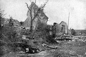
Carency was heavily damaged during World War I. This image shows it after it was recaptured by French troops.
Notable people
François Faber, winner of the 1909 Tour de France, died here fighting in the Second Battle of Artois, on 9 May 1915, during World War I.
See also
References
External links
| Wikimedia Commons has media related to Carency. |
- Carency on the Quid website (French)
- Communaupole of Lens-Liévin website (French)
This article is issued from Wikipedia - version of the 11/15/2016. The text is available under the Creative Commons Attribution/Share Alike but additional terms may apply for the media files.