Carolina Heights Historic District
|
Carolina Heights Historic District | |
|
Hazelhurt House | |
  | |
| Location | Roughly bounded by Market St., Thirteenth St., Rankin St. and Nineteenth St., Wilmington, North Carolina |
|---|---|
| Coordinates | 34°14′19″N 77°55′59″W / 34.23861°N 77.93306°WCoordinates: 34°14′19″N 77°55′59″W / 34.23861°N 77.93306°W |
| Area | 81.5 acres (33.0 ha) |
| Built | c. 1908 |
| Architect | Stephens, Burett; Gause, James F., et al. |
| Architectural style | Queen Anne, Colonial Revival, Classical Revival |
| NRHP Reference # | 99000317, 99001448 (Boundary Increase)[1] |
| Added to NRHP | July 29, 1999, November 30, 1999 (Boundary Increase) |
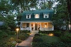
Carolina Heights Historic District is a national historic district located at Wilmington, New Hanover County, North Carolina. The district encompasses 421 contributing buildings, 1 contributing site, and 1 contributing object in a predominantly residential section of Wilmington. The district developed as planned suburban areas between about 1908 and 1950 and includes notable examples of Queen Anne, Classical Revival, Colonial Revival, and Bungalow / American Craftsman style architecture. Notable buildings include the New Hanover High School (1922), the Trinity Methodist Episcopal Church (1921), St. Paul's Episcopal Church (1927/1956-1958), First Church of Christ, Scientist (1928), Sinclair Service Station (c. 1936), and Yopp Funeral Home (1936).[2][3]
It was listed on the National Register of Historic Places in 1999, with a boundary increase in 1999.[1]
-

Jarman House
References
- 1 2 National Park Service (2010-07-09). "National Register Information System". National Register of Historic Places. National Park Service.
- ↑ Beth Keane (August 1998). "Carolina Heights Historic District" (pdf). National Register of Historic Places - Nomination and Inventory. North Carolina State Historic Preservation Office. Retrieved 2015-02-01.
- ↑ Beth Keane (April 1999). "Carolina Heights Historic District (Boundary Increase)" (pdf). National Register of Historic Places - Nomination and Inventory. North Carolina State Historic Preservation Office. Retrieved 2015-02-01.