| [3] |
Name on the Register[4] |
Image |
Date listed[5] |
Location |
City or town |
Description |
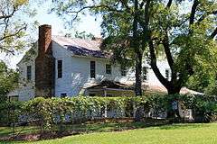
|---|
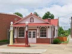
| 1 |
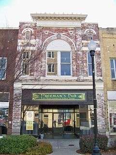
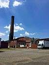
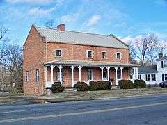
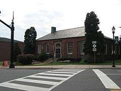
Beam's Shell Service Station and Office, (Former) |
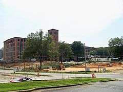
|
000000001997-10-17-0000October 17, 1997
(#97001221) |
117 N. Mountain St.
35°22′47″N 81°22′48″W / 35.379722°N 81.38°W / 35.379722; -81.38 (Beam's Shell Service Station and Office, (Former)) |
Cherryville |
|
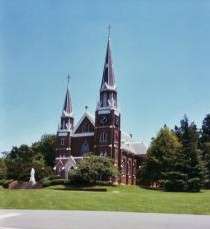
| 2 |
Belmont Abbey Cathedral |
|
000000001973-04-11-0000April 11, 1973
(#73001343) |
On SR 2093
35°15′43″N 81°02′36″W / 35.261944°N 81.043333°W / 35.261944; -81.043333 (Belmont Abbey Cathedral) |
Belmont |
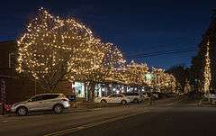
|
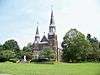
| 3 |
Belmont Abbey Historic District |
|
000000001993-07-14-0000July 14, 1993
(#93000584) |
100 Belmont-Mt. Holly Rd. (NC 2093, east side)
35°15′41″N 81°02′34″W / 35.261389°N 81.042778°W / 35.261389; -81.042778 (Belmont Abbey Historic District) |
Belmont |
|
| 4 |
Belmont Historic District |
|
000000001996-12-27-0000December 27, 1996
(#96001525) |
Roughly bounded by Sacred Heart College campus, RR line, N. and S. Main, Glenway, Bryant Sts., Keener Blvd., Central Ave
35°14′33″N 81°02′22″W / 35.2425°N 81.039444°W / 35.2425; -81.039444 (Belmont Historic District) |
Belmont |
|
| 5 |
Belmont Hosiery Mill |
Upload image |
000000002002-09-16-0000September 16, 2002
(#02000987) |
608 S. Main St.
35°14′15″N 81°02′54″W / 35.2375°N 81.048333°W / 35.2375; -81.048333 (Belmont Hosiery Mill) |
Belmont |
|
| 6 |
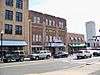
Bessemer City Downtown Historic District |
|
000000002014-05-19-0000May 19, 2014
(#14000228) |
Roughly bounded by 13th & E. Alabama Sts., E. & W. Virginia, E. Alabama & W. Pennsylvania Aves.
35°17′02″N 81°17′03″W / 35.2838°N 81.2841°W / 35.2838; -81.2841 (Bessemer City Downtown Historic District) |
Bessemer City |
|
| 7 |
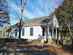
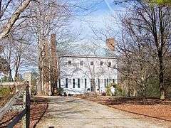
Andrew Carpenter House |
|
000000001983-03-17-0000March 17, 1983
(#83001883) |
SR 1820
35°23′19″N 81°03′07″W / 35.388611°N 81.051944°W / 35.388611; -81.051944 (Andrew Carpenter House) |
Lucia |
|
| 8 |
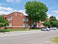
Central School |
|
000000002008-01-09-0000January 9, 2008
(#07001374) |
317 Washington Ave.
35°17′05″N 81°16′36″W / 35.284722°N 81.276667°W / 35.284722; -81.276667 (Central School) |
Bessemer City |
|
| 9 |
Cherryville Downtown Historic District |
Upload image |
000000002016-08-17-0000August 17, 2016
(#16000560) |
Main, Mountain, 1st, S. Jacob, S. Oak & N. Mulberry Sts.
35°22′44″N 81°22′46″W / 35.378999°N 81.379565°W / 35.378999; -81.379565 (Cherryville Downtown Historic District) |
Cherryville |
|
| 10 |
City Hospital-Gaston Memorial Hospital |
Upload image |
000000002011-12-07-0000December 7, 2011
(#11000889) |
401-405 N. Highland St., 810 W. Mauney Ave.
35°16′10″N 81°11′41″W / 35.269478°N 81.194656°W / 35.269478; -81.194656 (City Hospital-Gaston Memorial Hospital) |
Gastonia |
|
| 11 |
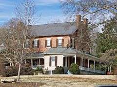
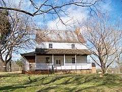
Craig Farmstead |
Upload image |
000000002006-04-19-0000April 19, 2006
(#06000292) |
118 Craigland Ln.
35°10′50″N 81°06′26″W / 35.180556°N 81.107222°W / 35.180556; -81.107222 (Craig Farmstead) |
Gastonia |
|
| 12 |
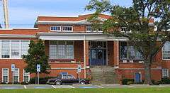
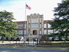
Dallas Graded and High School |
|
000000002002-05-02-0000May 2, 2002
(#02000441) |
300 W. Church St.
35°18′52″N 81°10′46″W / 35.314444°N 81.179444°W / 35.314444; -81.179444 (Dallas Graded and High School) |
Dallas |
|
| 13 |
Dallas Historic District |
|
000000001973-07-26-0000July 26, 1973
(#73001344) |
Bounded by Holland, Main, Gaston and Trade Sts.
35°18′58″N 81°10′35″W / 35.316111°N 81.176389°W / 35.316111; -81.176389 (Dallas Historic District) |
Dallas |
|
| 14 |
Downtown Gastonia Historic District |
|
000000002004-01-06-0000January 6, 2004
(#03001375) |
Roughly bounded by Main Ave., Broad St., Second Ave., and Chester St.
35°15′41″N 81°10′56″W / 35.261389°N 81.182222°W / 35.261389; -81.182222 (Downtown Gastonia Historic District) |
Gastonia |
|
| 15 |
Downtown Mount Holly Historic District |
|
000000002012-04-24-0000April 24, 2012
(#12000236) |
100 blocks of N. & S. Main Sts. & W. Central Ave.
35°17′52″N 81°00′58″W / 35.297851°N 81.016093°W / 35.297851; -81.016093 (Downtown Mount Holly Historic District) |
Mount Holly |
|
| 16 |
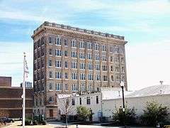
First National Bank Building |
|
000000001986-02-20-0000February 20, 1986
(#86000302) |
168-170 W. Main Ave.
35°15′49″N 81°10′59″W / 35.263611°N 81.183056°W / 35.263611; -81.183056 (First National Bank Building) |
Gastonia |
|
| 17 |
Former U.S. Post Office |
|
000000001995-11-29-0000November 29, 1995
(#95001401) |
115 N. Main St.
35°14′37″N 81°02′18″W / 35.243611°N 81.038333°W / 35.243611; -81.038333 (Former U.S. Post Office) |
Belmont |
|
| 18 |
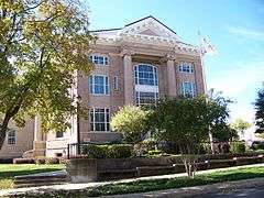
Gaston County Courthouse |
|
000000001979-05-10-0000May 10, 1979
(#79001708) |
N. York and S. South Sts.
35°15′47″N 81°11′04″W / 35.263056°N 81.184444°W / 35.263056; -81.184444 (Gaston County Courthouse) |
Gastonia |
|
| 19 |
Gastonia High School |
|
000000001983-03-17-0000March 17, 1983
(#83001884) |
S. York St.
35°15′10″N 81°11′19″W / 35.252778°N 81.188611°W / 35.252778; -81.188611 (Gastonia High School) |
Gastonia |
|
| 20 |
Hoyle House |
|
000000001993-10-21-0000October 21, 1993
(#93001140) |
NC 275 south side, 1,400 feet (430 m) southwest of the south fork of the Catawba River
35°19′36″N 81°08′17″W / 35.326667°N 81.138056°W / 35.326667; -81.138056 (Hoyle House) |
Dallas |
|
| 21 |
Eli Hoyle House |
|
000000001998-12-17-0000December 17, 1998
(#98001529) |
1111 Dallas-Stanley Hwy
35°19′37″N 81°08′28″W / 35.326944°N 81.141111°W / 35.326944; -81.141111 (Eli Hoyle House) |
Dallas |
|
| 22 |
David Jenkins House |
Upload image |
000000001978-02-17-0000February 17, 1978
(#78001956) |
1017 Church St.
35°15′58″N 81°09′59″W / 35.266111°N 81.166389°W / 35.266111; -81.166389 (David Jenkins House) |
Gastonia |
Burned July 1987[6]
|
| 23 |
Loray Mill Historic District |
|
000000002001-10-19-0000October 19, 2001
(#01001131) |
Roughly bounded by W. Franklin Blvd., S. Vance and S. Trenton Sts., and W. 6th Ave. B; also roughly bounded by S. Vance St., the railroad right-of-way, S. Hill St., and W. Franklin Boulevard
35°15′31″N 81°11′51″W / 35.258611°N 81.1975°W / 35.258611; -81.1975 (Loray Mill Historic District) |
Gastonia |
Second set of boundaries represents a boundary increase of 000000002006-04-05-0000April 5, 2006
|
| 24 |
Mayworth School |
|
000000002002-09-16-0000September 16, 2002
(#02000986) |
236 Eighth Ave.
35°14′26″N 81°04′32″W / 35.240556°N 81.075556°W / 35.240556; -81.075556 (Mayworth School) |
Cramerton |
|
| 25 |
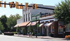
McAdenville Historic District |
|
000000002009-02-05-0000February 5, 2009
(#08001412) |
100-413 Main St., Elm and Poplar Sts., and cross sts. from I-85 to S. Fork of Catawba River
35°15′38″N 81°04′50″W / 35.260569°N 81.080653°W / 35.260569; -81.080653 (McAdenville Historic District) |
McAdenville |
|
| 26 |
Mount Holly Cotton Mill |
|
000000001996-08-01-0000August 1, 1996
(#96000830) |
250 N. Main St.
35°18′02″N 81°00′54″W / 35.300556°N 81.015°W / 35.300556; -81.015 (Mount Holly Cotton Mill) |
Mount Holly |
|
| 27 |
Robinson-Gardner Building |
|
000000001999-04-09-0000April 9, 1999
(#99000436) |
173-175 W. Main Ave.
35°15′49″N 81°11′00″W / 35.263611°N 81.183333°W / 35.263611; -81.183333 (Robinson-Gardner Building) |
Gastonia |
|
| 28 |
St. Joseph's Catholic Church |
|
000000001979-06-07-0000June 7, 1979
(#79001709) |
Off NC 273
35°20′12″N 81°00′01″W / 35.336667°N 81.000278°W / 35.336667; -81.000278 (St. Joseph's Catholic Church) |
Mountain Island |
|
| 29 |
Third National Bank Building |
|
000000001986-02-20-0000February 20, 1986
(#86000316) |
195 W. Main Ave.
35°15′49″N 81°11′02″W / 35.263611°N 81.183889°W / 35.263611; -81.183889 (Third National Bank Building) |
Gastonia |
|
| 30 |
William J. Wilson House |
|
000000001976-10-14-0000October 14, 1976
(#76001324) |
South of Gastonia off SR 1109
35°09′50″N 81°13′13″W / 35.163889°N 81.220278°W / 35.163889; -81.220278 (William J. Wilson House) |
Gastonia |
|
| 31 |
York-Chester Historic District |
Upload image |
000000002005-09-01-0000September 1, 2005
(#05000941) |
Bounded by W. Franklin Blvd., W. Second Ave., South St., W. Tenth Ave., W. Eighth Ave. and S. Clay St.
35°15′19″N 81°11′18″W / 35.255278°N 81.188333°W / 35.255278; -81.188333 (York-Chester Historic District) |
Gastonia |
|
_-_9-20-2014.jpg)
%2C_Cramerton%2C_NC_-_9-20-2014.jpg)
_9-20-2014.jpg)