Central Precinct, Randolph County, Illinois
| Central Precinct | |
|---|---|
|
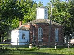
Charter Oak Schoolhouse, a historic site west of Schuline | |
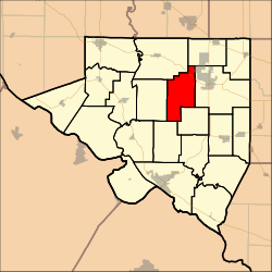 Location in Randolph County | |
| Coordinates: 38°06′11″N 089°46′30″W / 38.10306°N 89.77500°WCoordinates: 38°06′11″N 089°46′30″W / 38.10306°N 89.77500°W | |
| Country | United States |
| State | Illinois |
| County | Randolph |
| Area | |
| • Total | 31.5 sq mi (81.7 km2) |
| • Land | 31.1 sq mi (80.5 km2) |
| • Water | 0.5 sq mi (1.3 km2) 1.58% |
| Elevation | 528 ft (161 m) |
| Population (2010) | |
| • Total | 445 |
| • Density | 14/sq mi (5.4/km2) |
| GNIS feature ID | 1928460[1] |
Central Precinct is located in Randolph County, Illinois, USA. As of the 2010 census, its population was 445.[2]
Geography
Central Precinct covers an area of 31.5 square miles (81.7 km2).
References
- ↑ "US Board on Geographic Names". United States Geological Survey. 2007-10-25. Retrieved 2008-01-31.
- ↑ "Profile of General Population and Housing Characteristics: 2010 Demographic Profile Data (DP-1): Central precinct, Randolph County, Illinois". U.S. Census Bureau, American Factfinder. Archived from the original on September 11, 2013. Retrieved January 6, 2012.
Municipalities and communities of Randolph County, Illinois, United States | ||
|---|---|---|
| Cities | ||
| Villages | ||
| Precincts | ||
| Unincorporated communities | ||
This article is issued from Wikipedia - version of the 11/18/2016. The text is available under the Creative Commons Attribution/Share Alike but additional terms may apply for the media files.