Chemung, Pennsylvania
| Chemung, Pennsylvania | |
|---|---|
| Unincorporated community | |
 Chemung, Pennsylvania | |
| Coordinates: 41°35′26″N 76°50′20″W / 41.59056°N 76.83889°WCoordinates: 41°35′26″N 76°50′20″W / 41.59056°N 76.83889°W | |
| Country | United States |
| State | Pennsylvania |
| County | Lycoming |
| Elevation | 1,965 ft (599 m) |
| Time zone | Eastern (EST) (UTC-5) |
| • Summer (DST) | EDT (UTC-4) |
| Area code(s) | 570 |
| GNIS feature ID | 1203255[1] |
Chemung is an unincorporated community in McNett Township, Lycoming County, Pennsylvania, United States. Chemung is located on Quadrant Route 1013 (Ellenton Mountain Road) in extreme northern Lycoming County, 4.6 miles (7.4 km) south of Canton.[2]
References
- ↑ "Chemung". Geographic Names Information System. United States Geological Survey.
- ↑ Lycoming County, Pennsylvania General Highway Map (PDF) (Map). Pennsylvania Department of Transportation. 2011. Retrieved April 2, 2012.
Municipalities and communities of Lycoming County, Pennsylvania, United States | ||
|---|---|---|
| City | 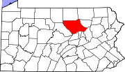 | |
| Boroughs | ||
| Townships |
| |
| CDPs | ||
| Unincorporated communities | ||
| Ghost town | ||
| Footnotes | ‡This populated place also has portions in an adjacent county | |
This article is issued from Wikipedia - version of the 11/21/2016. The text is available under the Creative Commons Attribution/Share Alike but additional terms may apply for the media files.