Rauchtown, Pennsylvania
| Rauchtown, Pennsylvania | |
|---|---|
| Census-designated place | |
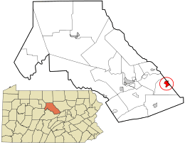 Location in Clinton County and the state of Pennsylvania. | |
| Coordinates: 41°7′22″N 77°14′9″W / 41.12278°N 77.23583°WCoordinates: 41°7′22″N 77°14′9″W / 41.12278°N 77.23583°W | |
| Country | United States |
| State | Pennsylvania |
| Counties | Clinton, Lycoming |
| Townships | Crawford, Limestone |
| Area | |
| • Total | 1.8 sq mi (4.6 km2) |
| • Land | 1.8 sq mi (4.6 km2) |
| • Water | 0.0 sq mi (0.0 km2) |
| Elevation | 889 ft (271 m) |
| Population (2010) | |
| • Total | 726 |
| • Density | 407/sq mi (157.3/km2) |
| Time zone | Eastern (EST) (UTC-5) |
| • Summer (DST) | EDT (UTC-4) |
| ZIP code | 17740 |
| FIPS code | 42-63496 |
| GNIS feature ID | 1184700 |
Rauchtown is a census-designated place[1] in Crawford Township, Clinton County, and a small portion in Limestone Township, Lycoming County, in the U.S. state of Pennsylvania. As of the 2010 census the population was 726.[2]
Rauchtown is on Pennsylvania Route 880 on the border between southeast Clinton County and southwest Lycoming County,[3] at the western end of a valley between Bald Eagle Mountain to the north and Nippenose Mountain to the south. Ravensburg State Park is on the southern edge of Rauchtown, in the narrow valley of Rauchtown Creek coming out of Nippenose Mountain.[4] PA 880 leads north (via PA 44) 7 miles (11 km) to the borough of Jersey Shore and south 6 miles (10 km) to the unincorporated community of Carroll, 1 mile (1.6 km) west of Exit 192 on Interstate 80.
References
- ↑ http://www.census.gov/2010census/
- ↑ "Geographic Identifiers: 2010 Census Summary File 1 (G001): Rauchtown CDP, Pennsylvania". U.S. Census Bureau, American Factfinder. Retrieved May 19, 2015.
- ↑ 2011 BOUNDARY AND ANNEXATION SURVEY (BAS): Lycoming County, PA (PDF) (Map). United States Department of Commerce, Bureau of the Census. 2011. Retrieved February 13, 2011.
- ↑ 2010 General Highway Map Clinton County Pennsylvania (PDF) (Map). 1:65,000. Pennsylvania Department of Transportation, Bureau of Planning and Research, Geographic Information Division. Retrieved 2011-02-14.
Municipalities and communities of Clinton County, Pennsylvania, United States | ||
|---|---|---|
| City | 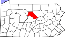 | |
| Boroughs | ||
| Townships | ||
| CDPs | ||
| Unincorporated communities | ||
| Footnotes | ‡This populated place also has portions in an adjacent county | |
Municipalities and communities of Lycoming County, Pennsylvania, United States | ||
|---|---|---|
| City | 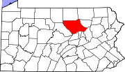 | |
| Boroughs | ||
| Townships |
| |
| CDPs | ||
| Unincorporated communities | ||
| Ghost town | ||
| Footnotes | ‡This populated place also has portions in an adjacent county | |