Columbia Township, Jackson County, Michigan
| Columbia Township, Michigan | |
|---|---|
| Township | |
|
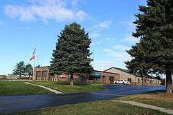
Township Offices, Jefferson Road | |
 Columbia Township, Michigan Location within the state of Michigan | |
| Coordinates: 42°6′14″N 84°17′12″W / 42.10389°N 84.28667°WCoordinates: 42°6′14″N 84°17′12″W / 42.10389°N 84.28667°W | |
| Country | United States |
| State | Michigan |
| County | Jackson |
| Area | |
| • Total | 39.3 sq mi (101.7 km2) |
| • Land | 36.6 sq mi (94.7 km2) |
| • Water | 2.7 sq mi (7.0 km2) |
| Elevation | 1,004 ft (306 m) |
| Population (2000) | |
| • Total | 7,234 |
| • Density | 197.8/sq mi (76.4/km2) |
| Time zone | Eastern (EST) (UTC-5) |
| • Summer (DST) | EDT (UTC-4) |
| FIPS code | 26-17400[1] |
| GNIS feature ID | 1626119[2] |
Columbia Township is a civil township of Jackson County in the U.S. state of Michigan. As of the 2000 census, the township population was 7,234.
Communities
- The village of Brooklyn is in the southeast of the township.
- Part of the village of Cement City stretches the county line with Lenawee and lies within the south-central part of the township.
- Clarklake is an unincorporated community around Clark Lake in the northwest of the township served by a US Post Office with the ZIP code of 49234. It began as a settlement in 1833.[3]
- Lake Columbia is an unincorporated community around Lake Columbia in the south central part of the township.
Geography

According to the United States Census Bureau, the township has a total area of 39.3 square miles (102 km2), of which 36.6 square miles (95 km2) is land and 2.7 square miles (7.0 km2) (6.90%) is water. The township is the headwaters of the River Rasin which passes through Vineyard Lake, Goose Creek passes through the manmade lake Lake Columbia then into the Rasin River. The head waters of the Grand River pass through the west end of the township. US 127 bounds the western boundary and M50 passes through the Village of Brooklyn through the township from north to south. The township contains the northern property of Michigan International Speedway.
Government
As of 2006:
- Supervisor, Robert Elrod
- Clerk, Barry Marsh
- Treasurer, John C. Calhoun
- Trustees, Rick DeLand, Brent Beamish, Philip Reynolds, Robin Tacket
The township has a 24/7 police department, as well as a part paid fire department (25 paid on call), with a full-time fire chief/fire inspector, and two fire stations.
Demographics
As of the census[1] of 2000, there were 7,234 people, 2,894 households, and 2,115 families residing in the township. The population density was 197.8 per square mile (76.4/km²). There were 3,552 housing units at an average density of 97.1 per square mile (37.5/km²). The racial makeup of the township was 97.82% White, 0.07% African American, 0.30% Native American, 0.36% Asian, 0.39% from other races, and 1.06% from two or more races. Hispanic or Latino of any race were 1.37% of the population.
There were 2,894 households out of which 29.3% had children under the age of 18 living with them, 63.0% were married couples living together, 7.0% had a female householder with no husband present, and 26.9% were non-families. 22.5% of all households were made up of individuals and 9.4% had someone living alone who was 65 years of age or older. The average household size was 2.48 and the average family size was 2.89.
In the township the population was spread out with 23.2% under the age of 18, 6.3% from 18 to 24, 26.6% from 25 to 44, 28.5% from 45 to 64, and 15.4% who were 65 years of age or older. The median age was 42 years. For every 100 females there were 98.0 males. For every 100 females age 18 and over, there were 94.9 males.
The median income for a household in the township was $51,632, and the median income for a family was $60,111. Males had a median income of $43,359 versus $30,410 for females. The per capita income for the township was $25,763. About 3.4% of families and 4.9% of the population were below the poverty line, including 6.2% of those under age 18 and 5.7% of those age 65 or over.
References
- 1 2 "American FactFinder". United States Census Bureau. Archived from the original on 2013-09-11. Retrieved 2008-01-31.
- ↑ U.S. Geological Survey Geographic Names Information System: Columbia Township, Jackson County, Michigan
- ↑ Walter Romig, Michigan Place Names, p. 118
Municipalities and communities of Jackson County, Michigan, United States | ||
|---|---|---|
| City | 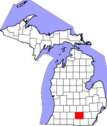 | |
| Villages | ||
| Charter townships | ||
| General law townships | ||
| CDPs | ||
| Other unincorporated communities | ||
| Footnotes | ‡This populated place also has portions in an adjacent county or counties | |