Clayton, Kansas
| Clayton, Kansas | |
|---|---|
| City | |
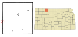 Location within Norton County and Kansas | |
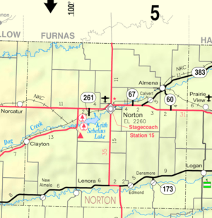 KDOT map of Norton County (legend) | |
| Coordinates: 39°44′14″N 100°10′37″W / 39.73722°N 100.17694°WCoordinates: 39°44′14″N 100°10′37″W / 39.73722°N 100.17694°W | |
| Country | United States |
| State | Kansas |
| Counties | Decatur, Norton |
| Area[1] | |
| • Total | 0.43 sq mi (1.11 km2) |
| • Land | 0.43 sq mi (1.11 km2) |
| • Water | 0 sq mi (0 km2) |
| Elevation | 2,418 ft (737 m) |
| Population (2010)[2] | |
| • Total | 59 |
| • Estimate (2015)[3] | 58 |
| • Density | 140/sq mi (53/km2) |
| Time zone | CST (UTC-6) |
| • Summer (DST) | CDT (UTC-5) |
| ZIP code | 67629 |
| Area code | 785 |
| FIPS code | 20-13675 [4] |
| GNIS feature ID | 0471080 [5] |
Clayton is a city in Decatur and Norton counties in the U.S. state of Kansas. As of the 2010 census, the city population was 59.[6]
History
The first post office in Clayton was established in March 1879.[7] Clayton was named for the valuable clay found in the vicinity.[8]
Clayton was incorporated as a city in 1907.[9]
Geography
Clayton is located at 39°44′14″N 100°10′37″W / 39.73722°N 100.17694°W (39.737247, -100.176818).[10] According to the United States Census Bureau, the city has a total area of 0.43 square miles (1.11 km2), all land.[1]
Demographics
| Historical population | |||
|---|---|---|---|
| Census | Pop. | %± | |
| 1910 | 191 | — | |
| 1920 | 258 | 35.1% | |
| 1930 | 226 | −12.4% | |
| 1940 | 153 | −32.3% | |
| 1950 | 157 | 2.6% | |
| 1960 | 161 | 2.5% | |
| 1970 | 127 | −21.1% | |
| 1980 | 102 | −19.7% | |
| 1990 | 91 | −10.8% | |
| 2000 | 66 | −27.5% | |
| 2010 | 59 | −10.6% | |
| Est. 2015 | 58 | [3] | −1.7% |
| U.S. Decennial Census | |||
2010 census
As of the census[2] of 2010, there were 59 people, 23 households, and 19 families residing in the city. The population density was 137.2 inhabitants per square mile (53.0/km2). There were 34 housing units at an average density of 79.1 per square mile (30.5/km2). The racial makeup of the city was 96.6% White and 3.4% Native American. Hispanic or Latino of any race were 1.7% of the population.
There were 23 households of which 21.7% had children under the age of 18 living with them, 56.5% were married couples living together, 13.0% had a female householder with no husband present, 13.0% had a male householder with no wife present, and 17.4% were non-families. 17.4% of all households were made up of individuals. The average household size was 2.57 and the average family size was 2.74.
The median age in the city was 50.9 years. 16.9% of residents were under the age of 18; 5.2% were between the ages of 18 and 24; 18.7% were from 25 to 44; 42.5% were from 45 to 64; and 16.9% were 65 years of age or older. The gender makeup of the city was 52.5% male and 47.5% female.
2000 census
As of the census[4] of 2000, there were 66 people, 27 households, and 18 families residing in the city. The population density was 155.1 people per square mile (59.3/km²). There were 37 housing units at an average density of 87.0 per square mile (33.2/km²). The racial makeup of the city was 98.48% White, and 1.52% from two or more races.
There were 27 households out of which 29.6% had children under the age of 18 living with them, 59.3% were married couples living together, and 33.3% were non-families. 25.9% of all households were made up of individuals and 3.7% had someone living alone who was 65 years of age or older. The average household size was 2.44 and the average family size was 3.00.
In the city the population was spread out with 25.8% under the age of 18, 3.0% from 18 to 24, 24.2% from 25 to 44, 33.3% from 45 to 64, and 13.6% who were 65 years of age or older. The median age was 44 years. For every 100 females there were 120.0 males. For every 100 females age 18 and over, there were 113.0 males.
The median income for a household in the city was $35,750, and the median income for a family was $35,625. Males had a median income of $39,375 versus $21,250 for females. The per capita income for the city was $13,519. There were 13.3% of families and 10.3% of the population living below the poverty line, including no under eighteens and none of those over 64.
References
- 1 2 "US Gazetteer files 2010". United States Census Bureau. Archived from the original on 2012-01-24. Retrieved 2012-07-06.
- 1 2 "American FactFinder". United States Census Bureau. Retrieved 2012-07-06.
- 1 2 "Annual Estimates of the Resident Population for Incorporated Places: April 1, 2010 to July 1, 2015". Retrieved July 2, 2016.
- 1 2 "American FactFinder". United States Census Bureau. Archived from the original on 2013-09-11. Retrieved 2008-01-31.
- ↑ "US Board on Geographic Names". United States Geological Survey. 2007-10-25. Retrieved 2008-01-31.
- ↑ "2010 City Population and Housing Occupancy Status". U.S. Census Bureau. Archived from the original on July 21, 2011. Retrieved September 14, 2011.
- ↑ "Kansas Post Offices, 1828-1961". Kansas Historical Society. Archived from the original on October 9, 2013. Retrieved 10 June 2014.
- ↑ "Profile for Clayton, Kansas". ePodunk. Retrieved 21 June 2014.
- ↑ Blackmar, Frank Wilson (1912). Kansas: A Cyclopedia of State History, Embracing Events, Institutions, Industries, Counties, Cities, Towns, Prominent Persons, Etc. Standard Publishing Company. p. 366.
- ↑ "US Gazetteer files: 2010, 2000, and 1990". United States Census Bureau. 2011-02-12. Retrieved 2011-04-23.
External links
| Wikimedia Commons has media related to Clayton, Kansas. |
- City
- Schools
- USD 294, local school district
- Maps
- Clayton City Map, KDOT
Municipalities and communities of Decatur County, Kansas, United States | ||
|---|---|---|
| Cities |  | |
| Unincorporated communities | ||
| Townships | ||
| Footnotes | ‡This populated place also has portions in an adjacent county or counties | |
Municipalities and communities of Norton County, Kansas, United States | ||
|---|---|---|
| Cities |  | |
| Unincorporated community | ||
| Footnotes | ‡This populated place also has portions in an adjacent county or counties | |