Jennings, Kansas
| Jennings, Kansas | |
|---|---|
| City | |
 Location within Decatur County and Kansas | |
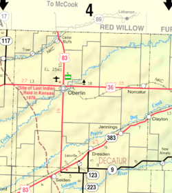 KDOT map of Decatur County (legend) | |
| Coordinates: 39°40′49″N 100°17′38″W / 39.68028°N 100.29389°WCoordinates: 39°40′49″N 100°17′38″W / 39.68028°N 100.29389°W | |
| Country | United States |
| State | Kansas |
| County | Decatur |
| Area[1] | |
| • Total | 0.27 sq mi (0.70 km2) |
| • Land | 0.27 sq mi (0.70 km2) |
| • Water | 0 sq mi (0 km2) |
| Elevation | 2,510 ft (765 m) |
| Population (2010)[2] | |
| • Total | 96 |
| • Estimate (2015)[3] | 95 |
| • Density | 360/sq mi (140/km2) |
| Time zone | CST (UTC-6) |
| • Summer (DST) | CDT (UTC-5) |
| ZIP code | 67643 |
| Area code | 785 |
| FIPS code | 20-35375 [4] |
| GNIS feature ID | 0471077 [5] |
Jennings is a city in Decatur County, Kansas, United States. As of the 2010 census, the city population was 96.[6]
History
The first post office at Jennings was established in 1874, but the post office there was called Slab City until 1879.[7]
Jennings was laid out in 1888.[8][9] It was named for Warren Jennings, a landowner.[10][11]
Jennings was located on the Chicago, Rock Island and Pacific Railroad.[12]
Geography
Jennings is located at 39°40′49″N 100°17′38″W / 39.68028°N 100.29389°W (39.680197, -100.293918).[13] According to the United States Census Bureau, the city has a total area of 0.27 square miles (0.70 km2), all of it land.[1]
Demographics
| Historical population | |||
|---|---|---|---|
| Census | Pop. | %± | |
| 1910 | 259 | — | |
| 1920 | 253 | −2.3% | |
| 1930 | 344 | 36.0% | |
| 1940 | 311 | −9.6% | |
| 1950 | 330 | 6.1% | |
| 1960 | 292 | −11.5% | |
| 1970 | 224 | −23.3% | |
| 1980 | 194 | −13.4% | |
| 1990 | 188 | −3.1% | |
| 2000 | 146 | −22.3% | |
| 2010 | 96 | −34.2% | |
| Est. 2015 | 95 | [3] | −1.0% |
| U.S. Decennial Census | |||
2010 census
As of the census[2] of 2010, there were 96 people, 50 households, and 30 families residing in the city. The population density was 355.6 inhabitants per square mile (137.3/km2). There were 89 housing units at an average density of 329.6 per square mile (127.3/km2). The racial makeup of the city was 99.0% White and 1.0% from two or more races.
There were 50 households of which 10.0% had children under the age of 18 living with them, 48.0% were married couples living together, 6.0% had a female householder with no husband present, 6.0% had a male householder with no wife present, and 40.0% were non-families. 34.0% of all households were made up of individuals and 18% had someone living alone who was 65 years of age or older. The average household size was 1.92 and the average family size was 2.37.
The median age in the city was 61.7 years. 8.3% of residents were under the age of 18; 5.2% were between the ages of 18 and 24; 14.6% were from 25 to 44; 26.1% were from 45 to 64; and 45.8% were 65 years of age or older. The gender makeup of the city was 50.0% male and 50.0% female.
2000 census
As of the census[4] of 2000, there were 146 people, 73 households, and 41 families residing in the city. The population density was 537.9 people per square mile (208.8/km²). There were 99 housing units at an average density of 364.7 per square mile (141.6/km²). The racial makeup of the city was 100.00% White. Hispanic or Latino of any race were 0.68% of the population.
There were 73 households out of which 13.7% had children under the age of 18 living with them, 50.7% were married couples living together, and 43.8% were non-families. 37.0% of all households were made up of individuals and 21.9% had someone living alone who was 65 years of age or older. The average household size was 2.00 and the average family size was 2.54.
In the city the population was spread out with 15.1% under the age of 18, 8.2% from 18 to 24, 25.3% from 25 to 44, 19.9% from 45 to 64, and 31.5% who were 65 years of age or older. The median age was 46 years. For every 100 females there were 117.9 males. For every 100 females age 18 and over, there were 106.7 males.
The median income for a household in the city was $21,146, and the median income for a family was $42,917. Males had a median income of $29,107 versus $21,667 for females. The per capita income for the city was $16,294. There were none of the families and 12.0% of the population living below the poverty line, including no under eighteens and 9.5% of those over 64.
References
- 1 2 "US Gazetteer files 2010". United States Census Bureau. Retrieved 2012-07-06.
- 1 2 "American FactFinder". United States Census Bureau. Retrieved 2012-07-06.
- 1 2 "Annual Estimates of the Resident Population for Incorporated Places: April 1, 2010 to July 1, 2015". Retrieved July 2, 2016.
- 1 2 "American FactFinder". United States Census Bureau. Retrieved 2008-01-31.
- ↑ "US Board on Geographic Names". United States Geological Survey. 2007-10-25. Retrieved 2008-01-31.
- ↑ "2010 City Population and Housing Occupancy Status". U.S. Census Bureau. Retrieved May 14, 2011.
- ↑ "Kansas Post Offices, 1828-1961 (archived)". Kansas Historical Society. Archived from the original on October 9, 2013. Retrieved 8 June 2014.
- ↑ Blackmar, Frank Wilson (1912). Kansas: A Cyclopedia of State History. Standard Publishing Company. p. 27.
- ↑ "Decatur County". Blue Skyways. Kansas State Library. Retrieved 7 June 2014.
- ↑ Kansas State Historical Society (1916). Biennial Report of the Board of Directors of the Kansas State Historical Society. Kansas State Printing Plant. p. 174.
- ↑ "Profile for Jennings, Kansas". ePodunk. Retrieved 8 June 2014.
- ↑ Gannett, Henry (1898). A Gazetteer of Kansas. Govt. Print. Off. p. 119.
- ↑ "US Gazetteer files: 2010, 2000, and 1990". United States Census Bureau. 2011-02-12. Retrieved 2011-04-23.
External links
| Wikimedia Commons has media related to Jennings, Kansas. |
- City
- Schools
- USD 294, local school district
- Maps
- Jennings City Map, KDOT
Municipalities and communities of Decatur County, Kansas, United States | ||
|---|---|---|
| Cities | 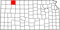 | |
| Unincorporated communities | ||
| Townships | ||
| Footnotes | ‡This populated place also has portions in an adjacent county or counties | |