Clinton, Maryland
| Clinton, Maryland | |
|---|---|
| Census-designated place | |
|
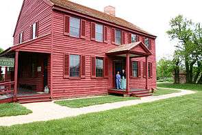
The Surratt House in May 2006 | |
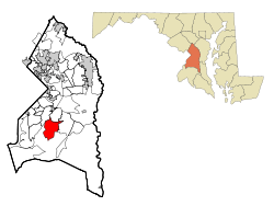 Location of Clinton, Maryland | |
| Coordinates: 38°45′49″N 76°53′44″W / 38.76361°N 76.89556°WCoordinates: 38°45′49″N 76°53′44″W / 38.76361°N 76.89556°W | |
| Country |
|
| State |
|
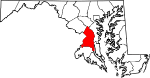
| County |
|
| Area | |
| • Total | 25.1 sq mi (64.9 km2) |
| • Land | 25.0 sq mi (64.8 km2) |
| • Water | 0.08 sq mi (0.2 km2) |
| Elevation | 249 ft (76 m) |
| Population (2010) | |
| • Total | 35,970 |
| • Density | 1,400/sq mi (550/km2) |
| Time zone | Eastern (EST) (UTC-5) |
| • Summer (DST) | EDT (UTC-4) |
| ZIP code | 20735 |
| Area code(s) | 301 |
| FIPS code | 24-17900 |
| GNIS feature ID | 0597253 |
Clinton is an unincorporated census-designated place (CDP) in Prince George's County, Maryland, United States.[1] Clinton was formerly known as Surrattsville until after the time of the American Civil War. The population of Clinton was 35,970 at the 2010 census.[2] Clinton is historically known for its role in the American Civil War concerning the Abraham Lincoln assassination. Clinton is adjacent to Camp Springs, Rosaryville, Melwood, and Andrews Air Force Base.
Geography
Clinton is located at 38°45′49″N 76°53′44″W / 38.76361°N 76.89556°W (38.763711, -76.895458).[3] According to the United States Census Bureau, the CDP has a total area of 25.1 square miles (64.9 km2), of which 25.0 square miles (64.7 km2) is land and 0.077 square miles (0.2 km2), or 0.31%, is water.[4]
Demographics
| Historical population | |||
|---|---|---|---|
| Census | Pop. | %± | |
| 1980 | 16,438 | — | |
| 1990 | 19,987 | 21.6% | |
| 2000 | 26,064 | 30.4% | |
| 2010 | 35,970 | 38.0% | |
| source:[2][5] | |||
As of the census[6] of 2000, there were 26,064 people, 8,605 households, and 6,772 families residing in the CDP. The population density was 2,208.6 people per square mile (852.8/km²). There were 8,962 housing units at an average density of 759.4 per square mile (293.2/km²). The racial makeup of the CDP was 20.56% White, 73.69% Black, 0.47% Native American, 2.47% Asian, 0.02% Pacific Islander, 0.72% from other races, and 2.08% from two or more races. Hispanic or Latino of any race were 1.90% of the population.
There were 8,605 households out of which 38.5% had children under the age of 18 living with them, 58.8% were married couples living together, 15.2% had a female householder with no husband present, and 21.3% were non-families. 17.4% of all households were made up of individuals and 5.3% had someone living alone who was 65 years of age or older. The average household size was 2.96 and the average family size was 3.32.
In the CDP the population was spread out with 27.2% under the age of 18, 6.7% from 18 to 24, 30.7% from 25 to 44, 26.4% from 45 to 64, and 9.1% who were 65 years of age or older. The median age was 37 years. For every 100 females there were 89.1 males. For every 100 females age 18 and over, there were 84.8 males.
The median income for a household in the CDP was $71,139, and the median income for a family was $75,036 (these figures had risen to $90,285 and $97,640 respectively as of a 2007 estimate[7]). Males had a median income of $41,736 versus $39,545 for females. The per capita income for the CDP was $24,949. About 2.4% of families and 3.4% of the population were below the poverty line, including 2.5% of those under age 18 and 10.2% of those age 65 or over.
History
Clinton was founded in the 1770s. The town, then named Surratt's Villa, was actually a simple crossroads with a few buildings. In the 1800s, it became known as Surrattsville. The main building served as the post office, an inn and tavern, and a polling place. This main residence was one of two properties owned by the widowed Mary Surratt; the second property was in Washington, D.C.[8]
On 14 and 15 April 1865, John Wilkes Booth, who had two hours earlier assassinated President Abraham Lincoln, stopped by the Surrattsville tavern to pick up weapons and supplies. The U.S. government alleged that Mary Surratt had gone there earlier with these supplies, and was in collusion with the conspirators, one of whom was her son, John Surratt. Because she was found guilty of complicity in the Lincoln assassination, Mary Surratt was hanged at the Capitol Prison in Washington D.C., on 7 July 1865. (Her house is now the Surratt House Museum, with a focus on the assassination.) The U.S. Post Office renamed the town Robeysville, due to the notoriety of the Surratt name, and in keeping with naming towns after the post master.
In 1879, Robeysville was renamed Clinton. The local high school, however, retains the name of Surrattsville, and some locals continue, in common usage, to call the town "Surattsville".
The Wyoming house, a historic frame house built in three phases between the 18th and early 19th centuries, is also a part of Clinton's history. The house consists of a main block with gambrel roof (late 18th century), kitchen (c. 1800), and connecting block (c. 1850). The Wyoming house is listed in the Maryland Inventory of Historical Properties and the Historic American Buildings Survey.[9]
In 1913, Blossie Keubeth Miller founded a general store at the town's main intersection. The current commercial property, built in the 1950s, houses a liquor store and was owned by the Miller family as recently as 2003.[10]
Clinton has mostly single-family housing, but includes a few townhouse developments and one retirement mid-rise. Southern Maryland Regional Hospital is in Clinton, as is a private airfield. Louise F. Cosca Regional Park, a public facility operated by the Maryland-National Capital Park and Planning Commission, offers camping, hiking, fishing in a lake, an excellent playground, and a nature museum with nature activities. Clinton boasts a major shopping complex as well, and has a large fringe parking lot nearby where Metro buses take passengers a few miles to the Branch Avenue station of the Washington Metrorail system. Clinton is also home to the James O. Hall Research Center which is located on the premises of the Surratts House.
Major local growth began in the 1950s, spurred partly by the expansion of adjacent Andrews Air Force Base, home of the Air Force Systems Command and the President's plane Air Force One.
A movie titled The Photon Effect was filmed in the town and also in Baltimore. A movie titled Safehouse was filmed in Clinton in 2007. Among the actors who flew out from Los Angeles to act in the film was Luke Barnett, who grew up in Clinton and graduated from Grace Brethren Christian School in 2000.
Clinton is also associated with the 2002 Beltway sniper attacks. A survivor of the attacks was shot in Clinton,[11] while Mildred Muhammad, ex-wife of sniper John Allen Muhammad, was a Clinton resident.[12]
Education
Clinton schools spend $6,986 per student. By average, there are 18 pupils per teacher, 789 students per librarian, and 431 children per counselor in Clinton (zip 20735), MD schools.
Primary and secondary schools
Public schools
Prince George's County Public Schools operates public schools that serve the area.
- Clinton Grove Elementary School
- Francis T. Evans Elementary School
- James Ryder Randall Elementary School
- Waldon Woods Elementary School
Middle schools:
High schools:
Special schools:
- Tanglewood Regional Center
Private schools
- Grace Brethren Christian Church and School
- St. John the Evangelist School
- Independent Baptist Academy
- Clinton Christian School
- St Mary's of Piscataway Catholic School and Church
Notable people
- Luke Barnett, actor known for his Funny or Die episodes
- Jenny Grace,[13] indie film actress, writer, and producer
- Dante Cunningham, American basketball player and power forward for the New Orleans Pelicans
- Joe Haden American Football Player and Defensive Back for the Cleveland Browns
- Marcia Gay Harden, Academy award winning actress
- Taraji P. Henson, actress
- Ty Lawson, American basketball player and point guard for the Houston Rockets
- Thomas V. Mike Miller, Jr., Maryland State Senate President
- Tank, R&B singer
- Delonte West NBA basketballer
- Brian Westbrook, NFL running back
- Laura Wright, actress
References
- ↑ U.S. Geological Survey Geographic Names Information System: Clinton, Maryland
- 1 2 "Profile of General Population and Housing Characteristics: 2010 Demographic Profile Data (DP-1): Clinton CDP, Maryland". U.S. Census Bureau, American Factfinder. Archived from the original on September 11, 2013. Retrieved December 18, 2011.
- ↑ "US Gazetteer files: 2010, 2000, and 1990". United States Census Bureau. 2011-02-12. Retrieved 2011-04-23.
- ↑ "Geographic Identifiers: 2010 Demographic Profile Data (DP-1): Clinton CDP, Maryland". U.S. Census Bureau, American Factfinder. Archived from the original on September 11, 2013. Retrieved December 18, 2011.
- ↑ "CENSUS OF POPULATION AND HOUSING (1790-2000)". U.S. Census Bureau. Retrieved 2010-07-18.
- ↑ "American FactFinder". United States Census Bureau. Archived from the original on 2013-09-11. Retrieved 2008-01-31.
- ↑ http://factfinder.census.gov/servlet/ACSSAFFFacts?_event=Search&geo_id=16000US1756640&_geoContext=01000US%7C04000US17%7C16000US1756640&_street=&_county=clinton&_cityTown=clinton&_state=04000US24&_zip=&_lang=en&_sse=on&ActiveGeoDiv=geoSelect&_useEV=&pctxt=fph&pgsl=160&_submenuId=factsheet_1&ds_name=ACS_2007_3YR_SAFF&_ci_nbr=null&qr_name=null®=null%3Anull&_keyword=&_industry=
- ↑ Diehl, Daniel; Donnelly, Mark P. (1 September 2015). Apparition Atlas: The Ghost Hunter’s Travel Guide to Haunted America. Gaia's Essence/Ravenswood Publishing. p. 167. ISBN 978-1-5152-6316-6.
- ↑ "Wyoming (Site Number PG:81B-4)" (PDF). Maryland Inventory of HIstoric Properties. Maryland Historical Trust. Retrieved 21 January 2016.
- ↑ "B. K. Miller Super Liquors (Site Number PG:81A-21)" (PDF). Maryland Inventory of Historic Properties. Maryland Historical Trust. Retrieved 21 January 2016.
- ↑ Dao, James (October 22, 2003). "Polite but Dogged, Sniper Suspect Offers Defense". The New York Times. Retrieved 21 January 2016.
- ↑ Kiehl, Stephen (November 20, 2003). "Muhammad's ex-wife recalls death threat". The Baltimore Sun. Retrieved 21 January 2016.
- ↑ http://www.imdb.com/name/nm1699461/?ref_=nmmd_md_nm