Collinwood Township, Meeker County, Minnesota
| Collinwood Township, Minnesota | |
|---|---|
| Township | |
 Collinwood Township, Minnesota Location within the state of Minnesota | |
| Coordinates: 45°1′N 94°19′W / 45.017°N 94.317°WCoordinates: 45°1′N 94°19′W / 45.017°N 94.317°W | |
| Country | United States |
| State | Minnesota |
| County | Meeker |
| Area | |
| • Total | 36.1 sq mi (93.4 km2) |
| • Land | 31.0 sq mi (80.4 km2) |
| • Water | 5.0 sq mi (13.0 km2) |
| Elevation | 1,125 ft (343 m) |
| Population (2000) | |
| • Total | 1,037 |
| • Density | 33.4/sq mi (12.9/km2) |
| Time zone | Central (CST) (UTC-6) |
| • Summer (DST) | CDT (UTC-5) |
| FIPS code | 27-12628[1] |
| GNIS feature ID | 0663849[2] |
Collinwood Township is a township in Meeker County, Minnesota, United States. The population was 1,037 at the 2000 census.
Collinwood Township was organized in 1866, and named after Collinwood Lake.[3]
Geography
According to the United States Census Bureau, the township has a total area of 36.1 square miles (93 km2), of which 31.0 square miles (80 km2) of it is land and 5.0 square miles (13 km2) of it (13.92%) is water.
Collinwood Township is located in Township 118 North of the Arkansas Base Line and Range 29 West of the 5th Principal Meridian.
Demographics
As of the census[1] of 2000, there were 1,037 people, 364 households, and 289 families residing in the township. The population density was 33.4 people per square mile (12.9/km²). There were 462 housing units at an average density of 14.9/sq mi (5.7/km²). The racial makeup of the township was 99.32% White, 0.10% Asian, 0.19% from other races, and 0.39% from two or more races. Hispanic or Latino of any race were 0.77% of the population.
There were 364 households out of which 36.3% had children under the age of 18 living with them, 73.9% were married couples living together, 2.5% had a female householder with no husband present, and 20.6% were non-families. 16.2% of all households were made up of individuals and 5.8% had someone living alone who was 65 years of age or older. The average household size was 2.85 and the average family size was 3.16.
In the township the population was spread out with 28.0% under the age of 18, 5.4% from 18 to 24, 25.6% from 25 to 44, 27.9% from 45 to 64, and 13.2% who were 65 years of age or older. The median age was 40 years. For every 100 females there were 114.3 males. For every 100 females age 18 and over, there were 113.4 males.
The median income for a household in the township was $56,786, and the median income for a family was $63,295. Males had a median income of $41,200 versus $30,000 for females. The per capita income for the township was $22,065. About 4.1% of families and 6.2% of the population were below the poverty line, including 11.6% of those under age 18 and 1.6% of those age 65 or over.
Steelesville
Located within the township is an area known as Steelesville. The community of Steelesville was first delineated by the school district of the same name. The school was a typical rural America one-room school building occupied by students in grades one through eight who resided in the confines of the Steelesville School district. Also located within the Steelesville community is the Steelesville Cemetery. The Steelesville Cemetery is a one-acre active cemetery, owned by Gethsemane Lutheran Church, Dassel, Minnesota, and maintained by the Steelesville Cemetery Association.
References
- 1 2 "American FactFinder". United States Census Bureau. Archived from the original on 2013-09-11. Retrieved 2008-01-31.
- ↑ "US Board on Geographic Names". United States Geological Survey. 2007-10-25. Retrieved 2008-01-31.
- ↑ Upham, Warren (1920). Minnesota Geographic Names: Their Origin and Historic Significance. Minnesota Historical Society. p. 338.
Municipalities and communities of Meeker County, Minnesota, United States | ||
|---|---|---|
| Cities | 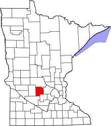 | |
| Townships | ||
| Unincorporated communities | ||
| Footnotes | ‡This populated place also has portions in an adjacent county or counties | |