Columbus County, North Carolina
| Columbus County, North Carolina | |
|---|---|
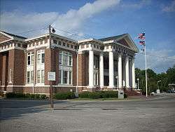 Columbus County Courthouse, Whiteville | |
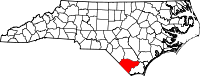 Location in the U.S. state of North Carolina | |
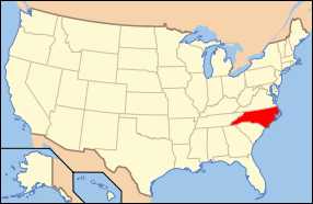 North Carolina's location in the U.S. | |
| Founded | 1808 |
| Named for | Christopher Columbus |
| Seat | Whiteville |
| Largest city | Whiteville |
| Area | |
| • Total | 954 sq mi (2,471 km2) |
| • Land | 937 sq mi (2,427 km2) |
| • Water | 16 sq mi (41 km2), 1.7% |
| Population | |
| • (2010) | 58,098 |
| • Density | 161/sq mi (62/km²) |
| Congressional district | 7th |
| Time zone | Eastern: UTC-5/-4 |
| Website |
www |
Columbus County is a county located in the U.S. state of North Carolina. As of the 2010 census, the population was 58,098.[1] Its county seat is Whiteville.[2]
Geography
According to the U.S. Census Bureau, the county has a total area of 954 square miles (2,470 km2), of which 937 square miles (2,430 km2) is land and 16 square miles (41 km2) (1.7%) is water.[3] It is the third-largest county in North Carolina by land area. There are several large lakes within the county, including Lake Tabor and Lake Waccamaw.
One of the most significant geographic features is the Green Swamp, a 15,907-acre area along highway 211 in the north-eastern portion of the county. It contains several unique and endangered species, such as the venus flytrap. The area contains the Brown Marsh Swamp, and has a remnant of the giant longleaf pine forest that once stretched across the Southeast from Virginia to Texas.[4]
Adjacent counties
- Bladen County - north
- Pender County - northeast
- Brunswick County - southeast
- Horry County, South Carolina - southwest
- Robeson County - northwest
Major highways
History
The county was formed in 1808 in the early federal period from parts of Bladen and Brunswick counties. It was named for Christopher Columbus.[5]
In 1983, State and Federal Investigators began Operation Gateway US, an investigation into the activities of several elected officials in Brunswick and Columbus counties. Law enforcement seized 37 million dollars of illegal drugs, and arrested several leading citizens in the area. The scandal was labeled "COLCOR" in the press, shorthand for Columbus Corruption.[6]
Waccamaw Siouan Indian tribe
The Waccamaw Siouan Indians are one of eight state-recognized tribes. Their homeland territory is at the edge of Green Swamp in present-day Columbus County. Historically, the "eastern Siouans" had territories extending through the area of Columbus County prior to any European exploration or settlement in the 16th century.
English colonial settlement in what was known as Carolina did not increase until the late 17th and early 18th centuries. Following epidemics of infectious disease, the indigenous peoples also suffered disruption and fatalities during the colonial Tuscarora and Yamasee wars. Afterward most of the Tuscarora people migrated north, joining other Iroquoian-speaking peoples of the Iroquois Confederacy in New York State by 1722, when they declared their migration ended and official tribe relocated to that area.
The Waccamaw Siouan ancestors retreated for safety to an area of Green Swamp near Lake Waccamaw.[7] Throughout the 19th century, the Waccamaw Siouan were seldom mentioned in the historical record. Toward the end of the century, the U.S. Census recorded common Waccamaw surnames among individuals in the small isolated communities of this area.[8]
In 1910, the earliest-known governmental body of the Waccamaw Indians was officially created, named the Council of Wide Awake Indians. At a time of racial segregation in North Carolina schools, the council sought to gain public funding for Indian schools, as the Lumbee (then known as Croatan Indians) had achieved in the late 19th century. They also hoped to gain federal recognition as a tribe, but it was rare for landless Indians and was associated with the tribes that had official treaties with the United States, typically those on reservations. The Council opened its first publicly funded school in 1933, founding others soon after. They continued to have difficulty in getting state funding for schools, as minorities had been disenfranchised in North Carolina since passage of a suffrage amendment in 1900 that created barriers to voter registration. The Council campaigned for federal recognition in 1940 during the President Franklin D. Roosevelt administration, which had passed the Indian Reorganization Act of 1934, encouraging tribes to re-establish self-government.[8]
The name Waccamaw Siouan was first officially used in US government documents in 1949, when a bill intended to grant the tribe federal recognition was introduced in Congress by the representative of this district.[8] The bill was defeated in committee the following year. But changes in federal policy following Native American activism in the 1960s and 1970s enabled the Waccamaw Indians to obtain more public funding and economic assistance even without federal recognition.[8]
The Waccamaw Siouan have been recognized by the North Carolina Commission of Indian Affairs since 1971, as one of eight state-recognized tribes. The tribe organized as the Waccamaw Siouan Development Association (WSDA), a nonprofit group founded in 1972. The group is headed by a nine-member board of directors, elected by secret ballot in elections open to all enrolled tribal members over the age of 18; in addition, the board includes a chief, whose role is largely symbolic.[8]
Demographics
| Historical population | |||
|---|---|---|---|
| Census | Pop. | %± | |
| 1810 | 3,022 | — | |
| 1820 | 3,912 | 29.5% | |
| 1830 | 4,141 | 5.9% | |
| 1840 | 3,941 | −4.8% | |
| 1850 | 5,909 | 49.9% | |
| 1860 | 8,597 | 45.5% | |
| 1870 | 8,474 | −1.4% | |
| 1880 | 14,439 | 70.4% | |
| 1890 | 17,856 | 23.7% | |
| 1900 | 21,274 | 19.1% | |
| 1910 | 28,020 | 31.7% | |
| 1920 | 30,124 | 7.5% | |
| 1930 | 37,720 | 25.2% | |
| 1940 | 45,663 | 21.1% | |
| 1950 | 50,621 | 10.9% | |
| 1960 | 48,973 | −3.3% | |
| 1970 | 46,937 | −4.2% | |
| 1980 | 51,037 | 8.7% | |
| 1990 | 49,587 | −2.8% | |
| 2000 | 54,749 | 10.4% | |
| 2010 | 58,098 | 6.1% | |
| Est. 2015 | 56,694 | [9] | −2.4% |
| U.S. Decennial Census[10] 1790-1960[11] 1900-1990[12] 1990-2000[13] 2010-2013[1] | |||
As of the census[14] of 2000, there were 54,749 people, 21,308 households, and 15,043 families residing in the county. The population density was 58/sq mi (23/km²). As of 2004, there were 24,668 housing units at an average density of 26/sq mi (10/km²). The racial makeup for the county was 68.9% White, 23.1% Black or African American, 5.1% Native American, 0.2% Asian, 4.7% from other races, and 0.6% from two or more races. 2.7% of the population were Hispanic or Latino of any race.
By 2005 62.3% of the county population was White. 31.1% of the population was African-American. 3.2% of the population was Native American. According to the 2010 census, 1,025 people in Columbus County self-identify as Waccamaw Siouan.[15] 2.8% of the population was Latino.
There were 21,308 households out of which 31.50% had children under the age of 18 living with them, 50.80% were married couples living together, 15.80% had a female householder with no husband present, and 29.40% were non-families. 26.50% of all households were made up of individuals and 11.70% had someone living alone who was 65 years of age or older. The average household size was 2.50 and the average family size was 3.01.
In the county the population was spread out with 25.70% under the age of 18, 8.70% from 18 to 24, 27.40% from 25 to 44, 24.40% from 45 to 64, and 13.80% who were 65 years of age or older. The median age was 37 years. For every 100 females there were 92.60 males. For every 100 females age 18 and over, there were 89.40 males.
The 2003 median income for a household in the county was $27,659, and the median income for a family was a little more than $33,800. Males had a median income of $28,494 versus $19,867 for females. The per capita income for the county was $14,415. About 17.60% of families and 20.30% of the population were below the poverty line, including 30.00% of those under age 18 and 25.50% of those age 65 or over.
Economics
The economy of Columbus County centers on two different industries: agriculture and manufacturing. Columbus farmers produce crops such as pecans and peanuts along with soybeans, potatoes, and corn. Cattle, poultry, and catfish are other agricultural products in Columbus County. Factories in the region focus on textiles, tools, and plywood. Household products such as doors, furniture, and windows are other manufactured goods produced in Columbus.[16]
Carolina Southern stopped railroad service to the county in 2012, and efforts to restore service have proven difficult.[17] However, as of July 2014, positive developments were reported to return railroad service to the area, a move considered necessary for spurring economic development in the area.[18] Carolina Southern agreed, in July 2014, to begin the process allowing the counties of Horry County, South Carolina, Marion, South Carolina and Columbus County, NC to assume control of the area rail lines with the hopes repairing the railroad tracks and bridges and then finding a buyer to re-establish service to the area.[19] A public hearing on the matter was held on October 6, 2014.[20] During the October 6th meeting, the Columbus County Commissioners voted to support the initiative to restart rail service with a 10-year grant for the program. Some of the commissioners may not have revealed that they will benefit from the re-establishment of rail service.[21] The Horry County Council, in a vote on October 7, 2014 also voted to provide funding to reestablish railroad service to the area.[22] Although originally it was thought service could be restored as early as spring 2015,[23] however, the sale of the railroad was not completed until August, 2015 to R.J. Coleman Railroad..[24] A new target date of February 2016 was announced, as millions of dollars are expected to be spent repairing the rail lines that have been idle since 2011.[25]
Law and government
Columbus County is a member of the regional Cape Fear Council of Governments. The county is governed by a board of seven Commissioners.
Columbus County Animal Shelter
Columbus County maintains an animal shelter at 288 Legion Drive in Whiteville, NC. It has been a target both from government regulators as well as activist [26] with problems present for "years and years and years" [27] In the past, the shelter has been fined [28] as well as receiving warning from state regulators for various issues.[29]
In September 2015, a new manager was hired to combat these issues,[30] and he announced an ambitious plan to improve the shelter. In late October 2015, WECT ran a story showing that things at the shelter were indeed improving, highlighting a large donation from Austria that was made possible by coordination on Facebook. The story also enumerated more changes that the new director has made to improve conditions.[26] As of November 2015, the volunteers maintain a Facebook page showing the animals the shelter has available for adoption.[31]
Libraries
The county maintains a system of 6 libraries. The first public library for the county opened in 1921.[32]
Prisons
There are two state prisons in the county, one at Tabor City, the Tabor City Correctional Institution, and one at Brunswick,[33]
Sheriff Department
The Sheriff's office provides law enforcement services for the county as well as operating the Columbus County Detention Center. As of January 2016, the current sheriff is Lewis Hatcher.[34]
Communities
Cities

- Tabor City
- Whiteville (named county seat in 1832 [29])
Towns
Townships
- Bogue
- Bolton
- Bug Hill
- Cerro Gordo
- Chadbourn
- Fair Bluff
- Lees
- Ransom
- South Williams
- Tatums
- Waccamaw
- Welch Creek
- Western Prong
- Williams
- Whiteville
Census-designated places
Unincorporated areas
See also
References
- 1 2 "State & County QuickFacts". United States Census Bureau. Retrieved October 18, 2013.
- ↑ "Find a County". National Association of Counties. Archived from the original on 2011-05-31. Retrieved 2011-06-07.
- ↑ "2010 Census Gazetteer Files". United States Census Bureau. August 22, 2012. Retrieved January 13, 2015.
- ↑ "The Green Swamp", My Reporter, April 2009
- ↑ Gannett, Henry (1905). The Origin of Certain Place Names in the United States. Govt. Print. Off. p. 88.
- ↑
- ↑ William S. Powell, Encyclopedia of North Carolina (Chapel Hill: University of North Carolina Press, 2006), 1170.
- 1 2 3 4 5 Powell, Encyclopedia of North Carolina, 1170.
- ↑ "County Totals Dataset: Population, Population Change and Estimated Components of Population Change: April 1, 2010 to July 1, 2015". Retrieved July 2, 2016.
- ↑ "U.S. Decennial Census". United States Census Bureau. Archived from the original on April 22, 2013. Retrieved January 13, 2015.
- ↑ "Historical Census Browser". University of Virginia Library. Retrieved January 13, 2015.
- ↑ Forstall, Richard L., ed. (March 27, 1995). "Population of Counties by Decennial Census: 1900 to 1990". United States Census Bureau. Retrieved January 13, 2015.
- ↑ "Census 2000 PHC-T-4. Ranking Tables for Counties: 1990 and 2000" (PDF). United States Census Bureau. April 2, 2001. Retrieved January 13, 2015.
- ↑ "American FactFinder". United States Census Bureau. Archived from the original on 2013-09-11. Retrieved 2008-01-31.
- ↑ Commission on Indian Affairs, North Carolina Department of Administration. (2010). "Total Population by Tribe by County in North Carolina." http://www.doa.nc.gov/cia/documents/populationdata/TotalPopulationbyTribebyNCCounty.pdf
- ↑ http://www.northcarolinahistory.org/encyclopedia/700/entry
- ↑ Jones, Steve. "STB filing: Railroad revenue not important in reaching a decision | Business". MyrtleBeachOnline.com. Retrieved 2014-04-22.
- ↑ "Tabor-Loris Tribune – July 16, 2014". tabor-loris.com. Retrieved 2014-12-06.
- ↑ "Local news from The Sun News in Myrtle Beach SC | MyrtleBeachOnline.com". myrtlebeachonline.com. Retrieved 2014-12-06.
- ↑ "Tabor-Loris Tribune – September 17, 2014". tabor-loris.com. Retrieved 2014-12-06.
- ↑ Justin Smith (2014-10-07). "Commissioner could benefit from railroad receiving county incent – WECT TV6-WECT.com:News, weather & sports Wilmington, NC". wect.com. Retrieved 2014-12-06.
- ↑ "CONWAY: Horry County Council approves $1.8 m commitment to help purchase Carolina Southern Railroad | Local News | MyrtleBeachOnline.com". myrtlebeachonline.com. Retrieved 2014-12-06.
- ↑ "Carolina Southern could roll again by next spring | Business | MyrtleBeachOnline.com". myrtlebeachonline.com. Retrieved 2014-12-06.
- ↑ "Archived copy". Archived from the original on 2015-09-10. Retrieved 2015-11-04.
- ↑ http://www.wect.com/story/29652747/done-deal-railroad-that-serves-columbus-county-changes-hands
- 1 2 http://www.wect.com/clip/11957953/new-animal-control-director-seeks-to-improve-columbus-co-shelter
- ↑ http://columbusco.org/Departments/AnimalControl.aspx
- ↑ http://www.wwaytv3.com/2015/06/24/columbus-county-animal-shelter-fined-again/
- 1 2 http://www.ncagr.gov/vet/aws/penalties.htm
- ↑ http://www.fayobserver.com/news/local/columbus-county-hires-new-director-of-animal-control/article_9e71e8df-7e86-5bd9-a8e0-fe918d53a9dd.html
- ↑ https://www.facebook.com/Urgent-Dogs-of-Columbus-County-Animal-Shelter-NC-345448152233233/
- ↑ http://columbusco.org/Departments/Library.aspx
- ↑ http://www.doc.state.nc.us/DOP/index.htm
- ↑ http://columbuscountysheriff.com/
External links
 |
Robeson County | Bladen County | Pender County | |
| |
||||
| ||||
| | ||||
| Horry County, South Carolina | Brunswick County |
Municipalities and communities of Columbus County, North Carolina, United States | ||
|---|---|---|
| City | 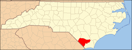 | |
| Towns | ||
| CDPs | ||
| Unincorporated communities | ||
Coordinates: 34°16′N 78°40′W / 34.26°N 78.67°W