Iredell County, North Carolina
| Iredell County, North Carolina | ||
|---|---|---|
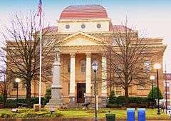 Iredell County Courthouse in Statesville | ||
| ||
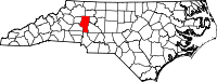 Location in the U.S. state of North Carolina | ||
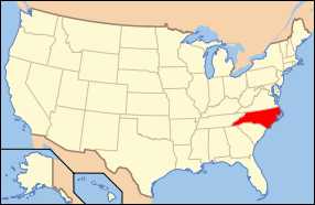 North Carolina's location in the U.S. | ||
| Founded | 1788 | |
| Seat | Statesville | |
| Largest town | Mooresville | |
| Area | ||
| • Total | 597 sq mi (1,546 km2) | |
| • Land | 574 sq mi (1,487 km2) | |
| • Water | 23 sq mi (60 km2), 3.9% | |
| Population | ||
| • (2010) | 159,437 | |
| Congressional districts | 5th, 9th | |
| Time zone | Eastern: UTC-5/-4 | |
| Website |
www | |

Iredell County is a county located in the U.S. state of North Carolina. According to current US Census projections in 2014, the population was 166,675.[1] Its county seat is Statesville,[2] and its largest town is Mooresville. The county was formed in 1788, annexed from Rowan County.[3] It is named for James Iredell, a justice of the Supreme Court of the United States nominated by George Washington.[4]
Iredell County is included in the Charlotte–Concord–Gastonia, NC–SC Metropolitan Statistical Area.
Geography
According to the U.S. Census Bureau, the county has a total area of 597 square miles (1,550 km2), of which 574 square miles (1,490 km2) is land and 23 square miles (60 km2) (3.9%) is water.[5]
Iredell County is located within the Piedmont Region of central North Carolina. The northwestern section of the county contains the Brushy Mountains, a deeply eroded spur of the Blue Ridge Mountains far to the west. The highest point in Iredell County, Fox Mountain, is in the Brushies; it rises to 1,760 feet. Although the "Brushies", as they are often called locally, are not high in the normal sense, they do rise prominently above the surrounding countryside. The remainder of Iredell County consists of gently rolling countryside occasionally broken by low hills and small river valleys. The county's largest river, the Catawba, forms much of its western border. Lake Norman, North Carolina's largest manmade lake, is the most prominent geographic feature of southern Iredell County; it is often called North Carolina's "inland sea".
Iredell County is an important transportation center for the state, as Interstate 77 and Interstate 40 cross in northeast Statesville. This has given birth to the county's slogan "Crossroads for the Future." Residents have easy access going south on I-77 to Charlotte; north on I-77 to Elkin, North Carolina and Roanoke, Virginia; east on I-40 to Winston-Salem, Greensboro and Raleigh; and west along I-40 to Hickory, North Carolina and Asheville.
The northern third of Iredell county is highly rural and contains no large towns. Due to the thinly populated nature of this portion of the state, it is one of the select places in North Carolina where the speed limit on Interstate Highways exceeds 65 mph, as Interstate 77 north of Statesville has a speed limit of 70 mph.
Iredell County is one of the longest counties in the state and stretches for nearly fifty miles north to south from Yadkin County in the north to Mecklenburg in the south. The county is divided into seventeen townships: Barringer, Bethany, Chambersburg, Concord, Coddle Creek, Cool Springs, Davidson, Eagle Mills, Fallstown, New Hope, Olin, Sharpesburg, Shiloh, Statesville, Turnersburg, Union Grove Harmony
Adjacent counties
- Yadkin County – north
- Davie County – east
- Rowan County – east
- Cabarrus County – southeast
- Mecklenburg County – south
- Lincoln County – southwest
- Catawba County – southwest
- Alexander County – west
- Wilkes County – north
Demographics
| Historical population | |||
|---|---|---|---|
| Census | Pop. | %± | |
| 1790 | 5,430 | — | |
| 1800 | 8,856 | 63.1% | |
| 1810 | 10,972 | 23.9% | |
| 1820 | 13,071 | 19.1% | |
| 1830 | 14,918 | 14.1% | |
| 1840 | 15,685 | 5.1% | |
| 1850 | 14,719 | −6.2% | |
| 1860 | 15,347 | 4.3% | |
| 1870 | 16,931 | 10.3% | |
| 1880 | 22,675 | 33.9% | |
| 1890 | 25,462 | 12.3% | |
| 1900 | 29,064 | 14.1% | |
| 1910 | 34,315 | 18.1% | |
| 1920 | 37,956 | 10.6% | |
| 1930 | 46,693 | 23.0% | |
| 1940 | 50,424 | 8.0% | |
| 1950 | 56,303 | 11.7% | |
| 1960 | 62,526 | 11.1% | |
| 1970 | 72,197 | 15.5% | |
| 1980 | 82,538 | 14.3% | |
| 1990 | 92,931 | 12.6% | |
| 2000 | 122,660 | 32.0% | |
| 2010 | 159,437 | 30.0% | |
| Est. 2015 | 169,866 | [6] | 6.5% |
| U.S. Decennial Census[7] 1790-1960[8] 1900-1990[9] 1990-2000[10] 2010-2014[1] | |||
As of the census[11] of 2010, there were 159,437 people, and 59,593[12] households in the county. The population density was 277.8[12] people per square mile (82/km²). As of 2013 there were 69,325[12] housing units at an average density of 90 per square mile (35/km²). The racial makeup of the county was 83.3% White, 12.3% Black or African American, 0.5% Native American, 2.2% Asian, 0.1% Pacific Islander, 1.68% from other races, and 1.6% from two or more races. 7.0% of the population were Hispanic or Latino of any race.
According to the 2000 census data, there were 47,360 households out of which 33.50% had children under the age of 18 living with them, 57.80% were married couples living together, 11.30% had a female householder with no husband present, and 26.80% were non-families. 22.70% of all households were made up of individuals and 8.40% had someone living alone who was 65 years of age or older. The average household size was 2.56 and the average family size was 3.00.
In the county the population was spread out with 25.50% under the age of 18, 7.50% from 18 to 24, 31.30% from 25 to 44, 23.30% from 45 to 64, and 12.40% who were 65 years of age or older. The median age was 36 years. For every 100 females there were 96.10 males. For every 100 females age 18 and over, there were 93.10 males.
As of 2013,[12] the median income for a household in the county was $50,058. Males had a median income of $34,590 versus $24,031 for females. The per capita income for the county was $26,348.[12] About 6.20% of families and 13.5%[12] of the population were below the poverty line, including 10.10% of those under age 18 and 9.80% of those age 65 or over.
Law and government
Iredell County is governed by the Board of Commissioners, consisting of five commissioners elected at-large.
Iredell County Commissioners (2010–present): James Mallory (Chairman), Steve Johnson, Ken Robertson, Marvin Norman and Tommy Bowles, all Republicans.
The Sheriff of Iredell County is Darren E. Campbell (Republican), elected in December 2014 taking over from Phillip Redmond who was first elected in 1994.[13]
The Register of Deeds of Iredell County is Matt McCall (Republican), first elected in 2010. The Register of Deeds serves as custodian and manager of a large number of land records and vital records.
Iredell County is part of prosecutorial District 22A with Alexander County. The Iredell County Courthouse is located in the county seat of Statesville. The District Attorney is Sarah Kirkman. The Senior Superior Court Judge is Joe Crosswhite. The Senior District Court Judge is Dale Graham.
Economy
Ingersoll Rand has its North America headquarters in the Iredell County side of Davidson.[14][15] Lowe's has its corporate headquarters in Mooresville.
Farming is still a major source of income for many Iredell County residents. Dairy farming has been particularly popular in Iredell County for centuries, in both the northern and southern sections of the county. However, the rapid population growth and development in southern Iredell County is putting increasing pressure on farmlands, and many farms in this section are giving way to shopping centers, housing developments, and large corporate office parks.
Iredell County is a major hub of NASCAR racing, with many race shops located in the county (mostly around Mooresville). Universal Technical Institute operates NASCAR Technical Institute under licensing agreements. The school offers racing-related instruction to prepare the student for their job search in the racing industry. Many NASCAR drivers live around Mooresville and Lake Norman. Although northern Iredell County has retained much of its rural character, the southern half of the county is experiencing rapid suburbanization and population growth, largely due to the immense popularity of the Lake Norman area for residents of nearby Charlotte, North Carolina's largest city.
Education
The county is served by two traditional public school districts: Iredell-Statesville Schools (ISS) and Mooresville Graded School District (MGSD). The county is also served by several public charter schools including Pine Lake Preparatory, Langtree Charter Academy, American Renaissance School (ARS) and others.[16]
Iredell Statesville Schools District[17]
- High Schools: CCTL Early College High School[18] at Mitchell Community College, Career Academy and Technical School, Lake Norman High School, Monticello (combined elementary, middle, and high school, 4–12), North Iredell, Pressly (combined elementary, middle, and high school, K–12), South Iredell, Statesville Senior High School, Visual and Performing Arts Center at Statesville High at Statesville High School, West Iredell, Mount Mourne IB (combined middle and high schools, 6–8, 9–12 is at South Iredell High School), Northview IB (combined middle and high schools, 6–8, 9–12 is at South Iredell High School)
- Middle Schools: Brawley, East Iredell, Lakeshore, North Iredell, Statesville, Troutman, West Iredell
- Elementary Schools: Celeste Henkel, Central, Cloverleaf, Coddle Creek, Cool Spring, East Iredell, Harmony, Lake Norman, Lakeshore, N. B. Mills, Scotts, Sharon, Shepherd, Third Creek, Troutman, Union Grove, Woodland Heights
Mooresville Graded School District
- High Schools: Mooresville Senior High
- Middle Schools: Mooresville Intermediate, Mooresville Intermediate, Mooresville Middle
- Elementary Schools: Park View Elementary, South Elementary, Rocky River Elementary
Pine Lake Preparatory
- Pine Lake Preparatory offers classes K–12 on its campus. Pine Lake Prep High School is ranked 8th Best in College Preparedness of the 591 High Schools in North Carolina by U.S. News & World Report in the 2012–2013 academic year.[19] It also ranks 8th of all High Schools in North Carolina for Algebra Proficiency[20] and 11th in English Profiency[21] by U.S. News & World Report.
'Private Schools: 'Woodlawn School, private K-12 college prep school located at 135 Woodlawn School Loop Mooresville, NC 28115. Opened in 2002, it sits on a 61 acre campus, just south of Davidson College.
Transportation
Major highways
Railroads
Iredell County is served by two railroads, Alexander Railroad and Norfolk Southern Railway.
Communities
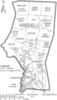
City
- Statesville (county seat)
Mooresville
Towns
- Davidson (part)
- Harmony
- Love Valley
- Troutman
Census-designated places
- Stony Point (part)
Unincorporated communities
Townships
- Barium Springs
- Barringer
- Bells Crossroads
- Bethany
- Chambersburg
- Coddle Creek
- Concord
- Cool Springs
- Doolie
- Eagle Mills
- Fallstown
- New Hope
- Olin
- Sharpesburg
- Sheperd/Shepherds
- Shiloh
- Stony Point
- Turnersburg
See also
- National Register of Historic Places listings in Iredell County, North Carolina
- USS Iredell County (LST-839)
References
- 1 2 "State & County QuickFacts". United States Census Bureau. Retrieved October 21, 2013.
- ↑ "Find a County". National Association of Counties. Retrieved 2011-06-07.
- ↑ "North Carolina History Project - Iredell County". Retrieved November 4, 2014.
- ↑ Gannett, Henry (1905). The Origin of Certain Place Names in the United States. Govt. Print. Off. p. 165.
- ↑ "2010 Census Gazetteer Files". United States Census Bureau. August 22, 2012. Retrieved January 17, 2015.
- ↑ "County Totals Dataset: Population, Population Change and Estimated Components of Population Change: April 1, 2010 to July 1, 2015". Retrieved July 2, 2016.
- ↑ "U.S. Decennial Census". United States Census Bureau. Retrieved January 17, 2015.
- ↑ "Historical Census Browser". University of Virginia Library. Retrieved January 17, 2015.
- ↑ Forstall, Richard L., ed. (March 27, 1995). "Population of Counties by Decennial Census: 1900 to 1990". United States Census Bureau. Retrieved January 17, 2015.
- ↑ "Census 2000 PHC-T-4. Ranking Tables for Counties: 1990 and 2000" (PDF). United States Census Bureau. April 2, 2001. Retrieved January 17, 2015.
- ↑ "American FactFinder". United States Census Bureau. Retrieved 2008-01-31.
- 1 2 3 4 5 6 http://quickfacts.census.gov/qfd/states/37/37097.html
- ↑ "Campbell takes oath as new Iredell sheriff". statesville.com. Retrieved 5 March 2015.
- ↑ "Contact Us." Ingersoll Rand. Retrieved on 18 January 2011. "North America Headquarters 800-E Beaty Street Davidson, NC 28036 USA"
- ↑ "Davidson Streets." City of Davidson. Retrieved on 18 January 2011.
- ↑ "Schools". ncpublicschools.org. Retrieved 2015-12-28.
- ↑ [Iredell-Statesville Schools web page
- ↑ "Collaborative College for Technology & Leadership". Retrieved 12 October 2012.
- ↑ "North Carolina High School Districts | Best High Schools". U.S. News & World Report. Retrieved 2015-12-28.
- ↑ "North Carolina High School Districts | Best High Schools". U.S. News & World Report. Retrieved 2015-12-28.
- ↑ "North Carolina High School Districts | Best High Schools". U.S. News & World Report. Retrieved 2015-12-28.
External links
- Iredell County government official website
-
 Geographic data related to Iredell County, North Carolina at OpenStreetMap
 |
Wilkes County | Yadkin County | Davie County | |
| Alexander County | |
Rowan County | ||
| ||||
| | ||||
| Lincoln County and Catawba County | Mecklenburg County | Cabarrus County |
Municipalities and communities of Iredell County, North Carolina, United States | ||
|---|---|---|
| City | 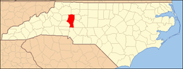 | |
| Towns | ||
| CDP | ||
| Unincorporated communities | ||
| Footnotes | ‡This populated place also has portions in an adjacent county or counties | |
|  | ||||||||||||||||||||
|
| |||||||||||||||||||||
Coordinates: 35°49′N 80°52′W / 35.81°N 80.87°W