Concordia, Mississippi
| Concordia, Mississippi | |
|---|---|
| Ghost town | |
 Concordia, Mississippi | |
| Coordinates: 33°58′39″N 90°57′02″W / 33.97750°N 90.95056°WCoordinates: 33°58′39″N 90°57′02″W / 33.97750°N 90.95056°W | |
| Country | United States |
| State | Mississippi |
| County | Bolivar |
| Elevation | 164 ft (50 m) |
| Time zone | Central (CST) (UTC-6) |
| • Summer (DST) | CDT (UTC-5) |
| GNIS feature ID | 691781 |
Concordia is a ghost town in Bolivar County, Mississippi, located on the eastern edge of the Mississippi Levee, approximately 2.5 mi (4.0 km) west of Mississippi Highway 1.
Once an important Mississippi River shipping point for cotton, little remains of the community but a cemetery.
History
Concordia is one of the oldest communities in Bolivar County. The Concordia Cemetery, located south of the community, has been used since 1848, and is marked with a historic plaque. The Concordia Methodist Church was also located there.[1]
Concordia was officially formed in 1866, and included "Carson's Landing", located north of the settlement.
Concordia had a population of about 250 by 1879, when yellow fever struck, killing half the population. The town was quarantined for a period.[2][3]
When the Louisville, New Orleans and Texas Railway was built in 1889, it passed 3 mi (4.8 km) east of the town, and many residents abandoned Concordia and moved to the nearby railway town of Gunnison.[3]
The town became further isolated sometime prior to 1939, when the Mississippi River changed its course. The river had previously followed the "Concordia Bend", with the town located on the east bank. Following the diversion, the main channel of the river moved approximately 5 mi (8.0 km) west, creating "Old River Lake", and oxbow lake, as well as Island No. 70 and Island No. 71.[4][5]
The area west of Concordia, between the levee and the Mississippi River, is currently used by the Concordia Hunting Club, and occupies 3,700 acres (1,500 ha).[6]
References
- ↑ "Historic Marker Inventory" (PDF). Mississippi Delta National Heritage Area. Retrieved January 2014. Check date values in:
|access-date=(help) - ↑ National Board of Health Bulletin. United States National Board of Health. 1879.
- 1 2 "Concordia: One of Bolivar County's First Settlements". Bolivar Bullet. November 1, 2002.
- ↑ Bragg, Marion (1977). Historic Names and Places on the Lower Mississippi River (PDF). Mississippi River Commission. p. 111.
- ↑ "Concordia Bend (historical)". Geographic Names Information System. United States Geological Survey.
- ↑ "Concordia Hunting Club Membership". Mossy Oak Properties. Retrieved January 2014. Check date values in:
|access-date=(help)
Municipalities and communities of Bolivar County, Mississippi, United States | ||
|---|---|---|
| Cities | 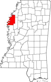 | |
| Towns | ||
| Unincorporated communities | ||
| Ghost towns | ||
| Footnotes | ‡This populated place also has portions in an adjacent county or counties | |