Confluence, Pennsylvania
| Confluence, Pennsylvania | |
|---|---|
| Borough | |
 | |
 | |
| Coordinates: 39°48′36″N 79°21′24″W / 39.81000°N 79.35667°WCoordinates: 39°48′36″N 79°21′24″W / 39.81000°N 79.35667°W | |
| Country | United States |
| State | Pennsylvania |
| County | Somerset |
| Settled | 1870 |
| Incorporated | 1873 |
| Government | |
| • Type | Borough Council |
| Area | |
| • Total | 1.6 sq mi (4 km2) |
| Population (2000) | |
| • Total | 834 |
| • Density | 522.4/sq mi (201.7/km2) |
| Time zone | Eastern (EST) (UTC-5) |
| • Summer (DST) | EDT (UTC-4) |
| Zip code | 15424 |
| Area code(s) | 814 |
Confluence is a borough in Somerset County, Pennsylvania, United States. It is part of the Somerset, Pennsylvania Metropolitan Statistical Area. The population was 834 at the 2000 census.
Geography
Confluence is located at 39°48′36″N 79°21′24″W / 39.81000°N 79.35667°W (39.809997, -79.356692).[1]
Confluence is so named for the juncture of the Casselman River and Laurel Hill Creek with the Youghiogheny River. It therefore provides many opportunities for boating and fishing (and hiking, as Pennsylvania's highest point, Mount Davis, is located nearby).
According to the United States Census Bureau, the borough has a total area of 1.6 square miles (4.1 km2), of which, 1.6 square miles (4.1 km2) of it is land and 0.1 square miles (0.26 km2) of it (3.03%) is water. The borough is bordered to the south by the 2,840-acre (11.5 km2) Youghiogheny River Lake and to the north by the 19,052-acre (77.10 km2) Ohiopyle State Park.
Climate
The climate in this area has mild differences between highs and lows, and there is adequate rainfall year round. According to the Köppen Climate Classification system, Confluence has a marine west coast climate, abbreviated "Cfb" on climate maps.[2]
Demographics
| Historical population | |||
|---|---|---|---|
| Census | Pop. | %± | |
| 1880 | 430 | — | |
| 1890 | 444 | 3.3% | |
| 1900 | 871 | 96.2% | |
| 1910 | 890 | 2.2% | |
| 1920 | 1,031 | 15.8% | |
| 1930 | 989 | −4.1% | |
| 1940 | 1,035 | 4.7% | |
| 1950 | 1,037 | 0.2% | |
| 1960 | 938 | −9.5% | |
| 1970 | 954 | 1.7% | |
| 1980 | 968 | 1.5% | |
| 1990 | 873 | −9.8% | |
| 2000 | 834 | −4.5% | |
| 2010 | 780 | −6.5% | |
| Est. 2015 | 749 | [3] | −4.0% |
| Sources:[4][5][6] | |||
As of the census[5] of 2000, there were 834 people, 349 households, and 211 families residing in the borough. The population density was 522.4 people per square mile (201.3/km²). There were 404 housing units at an average density of 253.0 per square mile (97.5/km²). The racial makeup of the borough was 99.52% White, 0.24% African American, and 0.24% from two or more races. Hispanic or Latino of any race were 0.24% of the population.
There were 349 households out of which 25.8% had children under the age of 18 living with them, 48.4% were married couples living together, 9.2% had a female householder with no husband present, and 39.3% were non-families. 34.4% of all households were made up of individuals and 21.8% had someone living alone who was 65 years of age or older. The average household size was 2.26 and the average family size was 2.91.
In the borough the population was spread out with 20.3% under the age of 18, 7.0% from 18 to 24, 26.9% from 25 to 44, 22.7% from 45 to 64, and 23.3% who were 65 years of age or older. The median age was 42 years. For every 100 females there were 84.9 males. For every 100 females age 18 and over, there were 79.7 males.
The median income for a household in the borough was $23,462, and the median income for a family was $31,181. Males had a median income of $26,705 versus $19,750 for females. The per capita income for the borough was $12,129. About 15.0% of families and 21.2% of the population were below the poverty line, including 28.7% of those under age 18 and 20.4% of those age 65 or over.
-
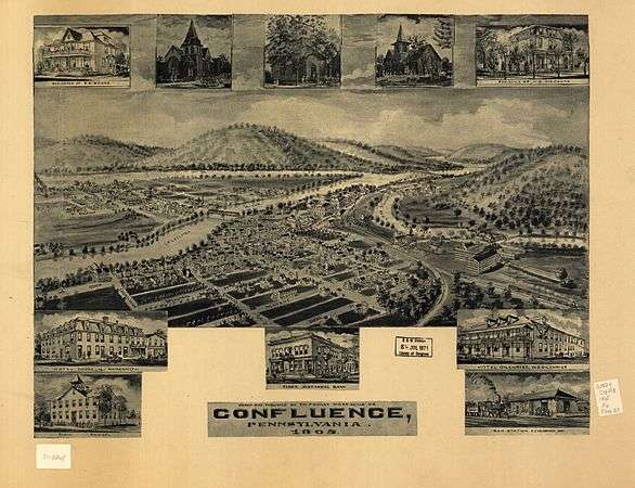
1905 bird's-eye view of Confluence
References
- ↑ "US Gazetteer files: 2010, 2000, and 1990". United States Census Bureau. 2011-02-12. Retrieved 2011-04-23.
- ↑ Climate Summary for Confluence, Pennsylvania
- ↑ "Annual Estimates of the Resident Population for Incorporated Places: April 1, 2010 to July 1, 2015". Retrieved July 2, 2016.
- ↑ "Census of Population and Housing". U.S. Census Bureau. Archived from the original on 11 May 2015. Retrieved 11 December 2013.
- 1 2 "American FactFinder". United States Census Bureau. Archived from the original on 2013-09-11. Retrieved 2008-01-31.
- ↑ "Incorporated Places and Minor Civil Divisions Datasets: Subcounty Resident Population Estimates: April 1, 2010 to July 1, 2012". Population Estimates. U.S. Census Bureau. Archived from the original on 17 June 2013. Retrieved 11 December 2013.
External links
Municipalities and communities of Somerset County, Pennsylvania, United States | ||
|---|---|---|
| Boroughs | 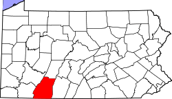 | |
| Townships | ||
| CDPs | ||
| Unincorporated communities | ||
| Footnotes | ‡This populated place also has portions in an adjacent county or counties | |