Summit Township, Somerset County, Pennsylvania
| Summit Township, Somerset County, Pennsylvania | |
|---|---|
| Township | |
|
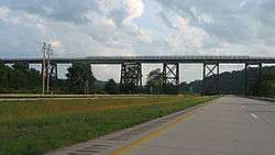
A massive rail viaduct between Meyersdale and Garrett | |
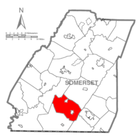 Map of Somerset County, Pennsylvania Highlighting Summit Township | |
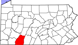 Map of Somerset County, Pennsylvania | |
| Country | United States |
| State | Pennsylvania |
| County | Somerset |
| Area | |
| • Total | 45.1 sq mi (117 km2) |
| Population (2000) | |
| • Total | 2,368 |
| • Density | 52.6/sq mi (20.3/km2) |
| Time zone | Eastern (EST) (UTC-5) |
| • Summer (DST) | EDT (UTC-4) |
Summit Township is a township in Somerset County, Pennsylvania in the United States. The population was 2,368 at the 2000 census. It is part of the Johnstown, Pennsylvania Metropolitan Statistical Area.
History
The W. Bollman and Company Bridge was added to the National Register of Historic Places in 1978.[1]
Geography
According to the United States Census Bureau, the township has a total area of 45.1 square miles (116.8 km²), of which, 45.1 square miles (116.7 km²) of it is land and 0.1 square miles (0.1 km²) of it (0.11%) is water.
Demographics
As of the census[2] of 2000, there were 2,368 people, 864 households, and 691 families residing in the township. The population density was 52.6 people per square mile (20.3/km²). There were 930 housing units at an average density of 20.6/sq mi (8.0/km²). The racial makeup of the township was 99.11% White, 0.21% African American, 0.08% Native American, 0.04% Asian, and 0.55% from two or more races. Hispanic or Latino of any race were 0.04% of the population.
There were 864 households out of which 33.2% had children under the age of 18 living with them, 70.3% were married couples living together, 5.8% had a female householder with no husband present, and 20.0% were non-families. 17.8% of all households were made up of individuals and 10.0% had someone living alone who was 65 years of age or older. The average household size was 2.73 and the average family size was 3.09.
In the township the population was spread out with 24.2% under the age of 18, 8.0% from 18 to 24, 26.4% from 25 to 44, 25.7% from 45 to 64, and 15.7% who were 65 years of age or older. The median age was 39 years. For every 100 females there were 100.3 males. For every 100 females age 18 and over, there were 98.8 males.
The median income for a household in the township was $32,115, and the median income for a family was $36,029. Males had a median income of $27,414 versus $20,559 for females. The per capita income for the township was $13,853. About 12.2% of families and 16.7% of the population were below the poverty line, including 20.8% of those under age 18 and 18.7% of those age 65 or over.
References
- ↑ National Park Service (2010-07-09). "National Register Information System". National Register of Historic Places. National Park Service.
- ↑ "American FactFinder". United States Census Bureau. Retrieved 2008-01-31.
Municipalities and communities of Somerset County, Pennsylvania, United States | ||
|---|---|---|
| Boroughs | | |
| Townships | ||
| CDPs | ||
| Unincorporated communities | ||
| Footnotes | ‡This populated place also has portions in an adjacent county or counties | |
Coordinates: 39°49′30″N 78°59′58″W / 39.82500°N 78.99944°W