Cottondale, Mississippi
| Cottondale, Mississippi | |
|---|---|
| Ghost town | |
 Cottondale, Mississippi  Cottondale, Mississippi | |
| Coordinates: 33°41′24″N 90°32′34″W / 33.69000°N 90.54278°WCoordinates: 33°41′24″N 90°32′34″W / 33.69000°N 90.54278°W | |
| Country | United States |
| State | Mississippi |
| County | Sunflower |
| Elevation | 121 ft (37 m) |
| Time zone | Central (CST) (UTC-6) |
| • Summer (DST) | CDT (UTC-5) |
| ZIP code | 38771 |
| Area code(s) | 662 |
| GNIS feature ID | 668853[1] |
Cottondale is a ghost town located in Sunflower County, Mississippi. Cottondale is located on U.S. Highway 49W and is approximately 2 miles (3.2 km) south of Ruleville and approximately 2.6 miles (4.2 km) north of Doddsville.
References
Municipalities and communities of Sunflower County, Mississippi, United States | ||
|---|---|---|
| Cities | 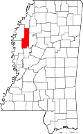 | |
| Towns | ||
| Unincorporated communities | ||
| Ghost towns | ||
| Footnotes | ‡This populated place also has portions in an adjacent county or counties | |
This article is issued from Wikipedia - version of the 7/30/2016. The text is available under the Creative Commons Attribution/Share Alike but additional terms may apply for the media files.