Lombardy, Mississippi
| Lombardy, Mississippi | |
|---|---|
| Unincorporated community | |
 Lombardy, Mississippi  Lombardy, Mississippi | |
| Coordinates: 33°54′20″N 90°36′25″W / 33.90556°N 90.60694°WCoordinates: 33°54′20″N 90°36′25″W / 33.90556°N 90.60694°W | |
| Country | United States |
| State | Mississippi |
| County | Sunflower |
| Elevation | 141 ft (36 m) |
| Time zone | Central (CST) (UTC-6) |
| • Summer (DST) | CDT (UTC-5) |
| ZIP code | 38737 |
| Area code(s) | 662 |
| GNIS feature ID | 672778[1] |
Lombardy is an unincorporated community located in northern Sunflower County, Mississippi. Lombardy is approximately 5.3 miles (8.5 km) south of Baltzer and approximately 7 miles (11 km) east of Mound Bayou at the junction of Lombardy and Mound Bayou Roads.
Notable people
- Wade Walton, blues musician, was born in Lombardy.[2]
References
- ↑ U.S. Geological Survey Geographic Names Information System: Lombardy, Mississippi
- ↑ Edward Komara; Peter Lee (1 July 2004). Blues Encyclopedia. Routledge. p. 1048. ISBN 978-1-135-95832-9.
Municipalities and communities of Sunflower County, Mississippi, United States | ||
|---|---|---|
| Cities | 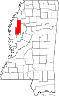 | |
| Towns | ||
| Unincorporated communities | ||
| Ghost towns | ||
| Footnotes | ‡This populated place also has portions in an adjacent county or counties | |
This article is issued from Wikipedia - version of the 10/28/2016. The text is available under the Creative Commons Attribution/Share Alike but additional terms may apply for the media files.