Daman, Daman and Diu
| Daman Damão દમણ | |
|---|---|
| City | |
|
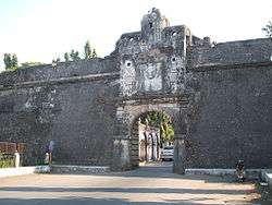
Gateway of Moti Daman | |
 Daman | |
| Coordinates: 20°25′N 72°51′E / 20.42°N 72.85°ECoordinates: 20°25′N 72°51′E / 20.42°N 72.85°E | |
| Country |
|
| State | Daman and Diu |
| District | Daman |
| Government | |
| • Member of Parliament | Lalubhai Patel |
| • Administrator | Praful Patel, Former Home Minister, Gujarat |
| • District Collector | Gaurav rajawat, IAS[1] |
| Area | |
| • Total | 72 km2 (28 sq mi) |
| Elevation | 5 m (16 ft) |
| Population (2011 Census) | |
| • Total | 191,173 |
| • Density | 2,700/km2 (6,900/sq mi) |
| Languages | |
| • Official | Gujarati , English |
| Time zone | IST (UTC+5:30) |
| Sex ratio | 1.69 ♂/♀ |
| Website |
www |
Daman /dəˈmɑːn/ (Damão in Portuguese), is a city and a municipal council in Daman district in the union territory of Daman & Diu, India.
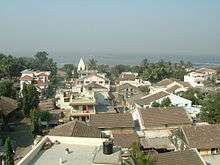
Daman city
Daman is divided by the Daman Ganga River into two parts, namely Nani-daman (Nani meaning "small") and Moti-daman (Moti meaning "big"). Ironically, Nani-daman is the larger of the two towns. It is the downtown area that holds most of the important entities like the major hospitals, supermarkets and major residential areas. While Moti-daman is mainly the old city inhabited.
History
The Portuguese Diogo de Melo arrived at the spot by chance in 1523, when heading towards Ormuz but caught in a violent storm and having his boat blown towards the coast of Daman.[2] Soon after it was settled as a Portuguese colony and remained so for over 400 years. A larger fort was built in Motidaman in the 16th century to guard against the Mughals who ruled the area until the Portuguese arrived. It still stands today, most of it preserved in its original form. Today the majority of the municipal government offices are situated inside this fort.
Daman was incorporated into the Republic of India in December 1961 after a battle between the Portuguese and the Indians. The battle left four Indians dead and 14 wounded,[3] and ten Portuguese dead and two wounded.[4]
Daman villages
There are many small villages around Daman, such as Bhenslore, Kunta, Bhimpor, Kadaiya, Devka Mangelad, Varkund and Khariwad. These villages mainly act as residential areas for lower-middle-class families.
Demographics
According to the 2011 census Daman District, India has a population of 191,173,[5] roughly equal to the nation of Samoa.[6] This gives it a ranking of 592nd in India (out of a total of 640).[5] The district has a population density of 2,655 inhabitants per square kilometre (6,880/sq mi) .[5] Its population growth rate over the decade 2001-2011 was 69.256%.[5] Daman has a sex ratio of 533 females for every 1,000 males,[5] and a literacy rate of 88.06%.[5]
Climate
| Climate data for Daman, India (1961-1990) | |||||||||||||
|---|---|---|---|---|---|---|---|---|---|---|---|---|---|
| Month | Jan | Feb | Mar | Apr | May | Jun | Jul | Aug | Sep | Oct | Nov | Dec | Year |
| Average high °C (°F) | 29.1 (84.4) |
29.9 (85.8) |
32.8 (91) |
34.5 (94.1) |
34.9 (94.8) |
33.2 (91.8) |
30.3 (86.5) |
29.9 (85.8) |
30.7 (87.3) |
33 (91) |
32.6 (90.7) |
30.4 (86.7) |
31.78 (89.16) |
| Average low °C (°F) | 15.7 (60.3) |
16.6 (61.9) |
20.3 (68.5) |
20.7 (69.3) |
26.5 (79.7) |
26.5 (79.7) |
25.3 (77.5) |
24.8 (76.6) |
24.3 (75.7) |
22.6 (72.7) |
19.2 (66.6) |
16.5 (61.7) |
21.58 (70.85) |
| Average precipitation mm (inches) | 0 (0) |
0 (0) |
1 (0.04) |
0 (0) |
5 (0.2) |
324 (12.76) |
766 (30.16) |
473 (18.62) |
288 (11.34) |
44 (1.73) |
6 (0.24) |
2 (0.08) |
1,909 (75.17) |
| Source: climate-data.org[7] | |||||||||||||
Tourism
- Nani Daman Fort
- Jain Temple : This 18th century Jain temple is situated in northern region of Nani Daman Fort and is dedicated to Mahavir Swami. The temple is built with white marbel and has beautiful carvings. The walls have very elegant glass cover with 18th century murals that represents the life of Mahavir Swami.[8]
- Fort of Moti Daman ( Jeronimo fort)
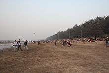
- Jampore Beach
- Devka Beach
- Church of Bom Jesus
- Daman Freedom Memorial
 Nani Daman Fort Entrance
.jpg) Jain Temple, Daman
Jain Temple, Daman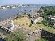 Harbour View from Moti Daman Fort
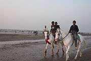 Jampore Beach in Daman
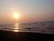 sunset at devka beach,daman
 Church in Nani Daman Fort
 church of Bom Jesus,daman
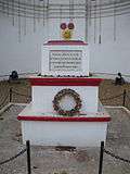 Daman Freedom Memorial
Indian Coast Guard
Indian Coast Guard Air Station, Daman is the premier air station of the Coast Guard and with all the airfield facilities, air traffic control and other allied air traffic services. The air station is equipped with state-of-the-art airport surveillance radar (ASR), precision approach path indicator (PAPI), Doppler very high frequency omnidirectional radio range (DVOR) – distance measuring equipment (DME) and nondirectional beacon (NDB), as navigational aids. This air station provides ATC and parking facilities to defence as well as civil aircraft.[9]
Schools and colleges
- Institute of our lady of Fatima, Convent, Moti Daman
- Podar Jumbo Kids, Daman - Best preschool
- Sunrise Champs school, Mashal Chowk,Nani Daman
- Sunrise Champs school, Vaidik Dental college campus, Salwaar, Nani Daman
- Shrinathji School, Varkund, Nani Daman
- Divya Jyoti English High & Higher Secondary School, Dabhel, Daman.
- Divya Jyoti Hindi Medium School, Dabhel, Daman.
- Coast Guard Public School, Nani Daman.
- MGM High School, Nani-Daman ( Sarvajanik High School).
- Government Higher Secondary School, Nani Daman.
- Government Higher Secondary School, Moti Daman.
- Government Polytechnic Daman
- Shree Machchi Mahajan English Medium School, Nani Daman.
- Stella Maris English Medium High School, Daman
- AIM English School, Moti Daman
- Government College, Nani Daman.
- Government Primary School, Devka Mangelwad, Nani Daman
- Holy Trinity English medium high school, Dunetha, Daman.
References
- ↑ U.T. Administration of Daman and Diu
- ↑ Singh, Kumar Suresh (1995). Daman and Diu. People of India. XIX. Popular Prakashan. p. 3. Retrieved 2010-12-18.
- ↑ Anil Shorey (21 February 1999). "The Forgotten Battles of Daman and Diu". The Tribune. Retrieved 18 December 2010.
- ↑ Chakravorty, Dr. B.C. (2008). "Operation Vijay". Bharat Rakshak. Retrieved 12/18/2010.
- 1 2 3 4 5 6 "District Census 2011". Census2011.co.in. 2011. Retrieved 2011-09-30.
- ↑ US Directorate of Intelligence. "Country Comparison: Population". Retrieved 2011-10-01.
Samoa 193,161
- ↑
- ↑ http://www.nrigujarati.co.in/tourism/174/Religious-Places/jain-temple-daman.html
- ↑ http://indiancoastguard.nic.in/
External links
| Wikimedia Commons has media related to Daman. |
| Wikivoyage has a travel guide for Daman (India). |