Kohima
| Kohima Kewhira | |
|---|---|
| Capital | |
 Kohima  Kohima Location of Kohima in Nagaland | |
| Coordinates: 25°40′12″N 94°06′28″E / 25.6701°N 94.1077°ECoordinates: 25°40′12″N 94°06′28″E / 25.6701°N 94.1077°E | |
| Country |
|
| State | Nagaland |
| District | Kohima |
| Area | |
| • Total | 20 km2 (8 sq mi) |
| Elevation | 1,444 m (4,738 ft) |
| Population (2011) | |
| • Total | 267,988 |
| • Density | 13,000/km2 (35,000/sq mi) |
| Languages | |
| • Official | English |
| Time zone | IST (UTC+5:30) |
| PIN | 797001 |
| Telephone code | 91 (0)370 |
| Vehicle registration | NL-01 |
| Sex ratio | 927 ♂/♀ |
| Website |
kohima |
Kohima /koʊˈhiːmə/ ![]() pronunciation ) is the hilly capital of India's north eastern border state of Nagaland which shares its borders with Burma. With a resident population of 267,988 it is the second largest city in the state. It lies in Kohima District and is one of the three Nagaland towns with Municipal council status along with Dimapur and Mokokchung.
pronunciation ) is the hilly capital of India's north eastern border state of Nagaland which shares its borders with Burma. With a resident population of 267,988 it is the second largest city in the state. It lies in Kohima District and is one of the three Nagaland towns with Municipal council status along with Dimapur and Mokokchung.
Kohima is the land of the Angami Naga tribe. The name, Kohima, was officially given by the British as they could not pronounce the Angami name Kewhima or Kewhira (Tenyidie for "the land where the flower Kewhi grows"). It is called after the wild flowering plant Kewhi, found in the mountains. Earlier, Kohima was also known as Thigoma. Kohima is located south of Kohima District (25°40′N 94°07′E / 25.67°N 94.12°E)[1] and has an average elevation of 1261 metres (4137 feet).[2] The town of Kohima is located on the top of a high ridge and the town serpentines along the top of the mountain ranges as is typical of most Naga settlements.
History
The British incursions into the Naga territory, beginning in the 1840s, met with stiff resistance from the independence-loving Nagas, who had never been conquered by any empire before. The stiffness of the resistance can be gauged by the fact that it took nearly four decades for the British to conquer a territory that is less than 10,000 square kilometres (the eastern region was left free). Kohima was the first seat of modern administration as the Headquarters of Naga Hills District (then under Assam) with the appointment of G.H. Damant as Political Officer in 1879. When Nagaland became a full-fledged state on 1 December 1963, Kohima was christened as the state capital.
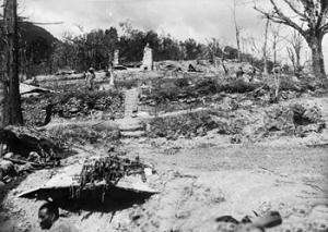
In 1944 during World War II the Battle of Kohima along with the simultaneous Battle of Imphal was the turning point in the Burma Campaign. For the first time in South-East Asia the Japanese lost the initiative to the Allies which they then retained until the end of the war. This hand-to-hand battle and slaughter prevented the Japanese from gaining a high base from which they might next roll across the extensive flatlands of India like a juggernaut.[3]
.jpeg)
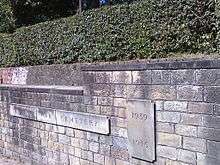
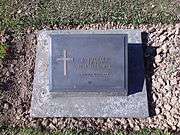
Kohima has a large cemetery known as the War Cemetery in Kohima for the Allied war dead maintained by the Commonwealth War Graves Commission. The cemetery lies on the slopes of Garrison Hill, in what was once the Deputy Commissioner's tennis court which was the scene of intense fighting, the Battle of the Tennis Court. The epitaph carved on the memorial of the 2nd British Division in the cemetery
| “ | When You Go Home, Tell Them Of Us And Say,
|
” |
has become world-famous as the Kohima poem. The verse is attributed to John Maxwell Edmonds (1875–1958), and is thought to have been inspired by the epitaph written by Simonides to honour the Greek who fell at the Battle of Thermopylae in 480 BC.[4]
Demographics
As of 2011, Kohima had a population of 267,988 of which males and females were 138,966 and 129,022 respectively. Kohima has an average literacy rate of 85.23%, higher than the national average of 74.04%. In Kohima, 13% of the population is under 6 years of age.
The town's population is composed of the 16 tribes of Nagaland. The population of the Angamis and Aos are the largest in present-day Kohima urban area.
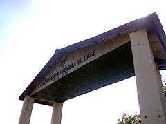
Greater Kohima which includes Kohima Village, Jakhama and Jotsoma along with Kohima town is the second largest urban area of Nagaland after Dimapur-Chumukedima. It has a population of about 100,000. 'Kohima Village' called 'Bara Basti' or 'large village',which is the second largest village in Asia forms the northeastern part of Kohima urban area today. The Bara Basti is divided into khels or localities. There are four of them, namely - Tsütuonuomia, Lhisemia, Dapfütsumia and Pfüchatsumia. They are termed shortly as T, L, D, and P Khel respectively.
Geography and climate
Kohima lies north of the Japfü Barail intersection. Due to its elevation, Kohima features a more moderate version of a humid subtropical climate (Cwa). Kohima has cool winters and hot very rainy summers. The coldest months are from December to February, when frost occurs and in the higher altitudes snowfall occurs occasionally. During the height of summers, from June–August, temperature ranges an average of 80–90 °F (27–32 °C). Heavy rainfall occurs during summer.
| Climate data for Kohima | |||||||||||||
|---|---|---|---|---|---|---|---|---|---|---|---|---|---|
| Month | Jan | Feb | Mar | Apr | May | Jun | Jul | Aug | Sep | Oct | Nov | Dec | Year |
| Record high °C (°F) | 23.5 (74.3) |
25.0 (77) |
29.1 (84.4) |
32.2 (90) |
33.9 (93) |
30.5 (86.9) |
33.1 (91.6) |
31.1 (88) |
31.0 (87.8) |
31.5 (88.7) |
29.5 (85.1) |
26.0 (78.8) |
33.9 (93) |
| Average high °C (°F) | 16.6 (61.9) |
17.9 (64.2) |
22.1 (71.8) |
24.1 (75.4) |
24.4 (75.9) |
24.9 (76.8) |
25.0 (77) |
25.4 (77.7) |
25.0 (77) |
23.4 (74.1) |
20.6 (69.1) |
17.7 (63.9) |
22.2 (72) |
| Average low °C (°F) | 8.1 (46.6) |
9.3 (48.7) |
12.7 (54.9) |
15.6 (60.1) |
16.9 (62.4) |
18.1 (64.6) |
18.8 (65.8) |
18.9 (66) |
18.1 (64.6) |
16.6 (61.9) |
13.1 (55.6) |
9.4 (48.9) |
14.6 (58.3) |
| Record low °C (°F) | 1.0 (33.8) |
2.3 (36.1) |
4.0 (39.2) |
5.0 (41) |
10.0 (50) |
9.4 (48.9) |
7.8 (46) |
8.3 (46.9) |
8.9 (48) |
5.0 (41) |
3.1 (37.6) |
2.8 (37) |
1.0 (33.8) |
| Average rainfall mm (inches) | 11.7 (0.461) |
35.4 (1.394) |
47.6 (1.874) |
88.7 (3.492) |
159.2 (6.268) |
333.8 (13.142) |
371.8 (14.638) |
364.0 (14.331) |
250.1 (9.846) |
126.0 (4.961) |
35.2 (1.386) |
7.8 (0.307) |
1,831.3 (72.098) |
| Average rainy days | 2.0 | 3.9 | 5.8 | 12.2 | 16.9 | 23.1 | 24.6 | 22.9 | 19.1 | 10.7 | 3.6 | 1.4 | 146.2 |
| Source #1: World Meteorological Organization[5] | |||||||||||||
| Source #2: India Meteorological Department (record low and high up to 2010)[6] | |||||||||||||
Nagaland Cuisine
Nagaland is the home of the hottest chili in the world, bhut jolokia, or the ghost peppers whose hotness scale is 855,000 SHU (Scoville Heat Units). All the tribes of Nagaland have their own cuisine, and they use a lot meat, fish, and fermented products in their dishes. However, the state dish is smoked pork cooked with fermented soya bean. The Naga dishes includes a lot of locally grown herbs, ghost peppers, ginger and garlic. Bizarre food that can be tried by die hard adventurers, here in Nagaland, are snails cooked with pork, silk worm larvae, which is an expensive delicacy of the state. There are options for vegetarians as well, galho, a porridge cooked with rice, leaves and condiments.
There are traditional drinks as well, dzutho and thutse, beers made with sticky rice. Nagaland is a food heaven for the food enthusiasts.
Hornbill Festival
The Hornbill Festival[7] was first initiated and proposed as Winter Carnival 2000 by BASN (Beauty and Aesthetics Society of Nagaland) before it was taken over by the Government of Nagaland who launched it in December 2000 as Hornbill Festival to encourage intertribal interaction and to promote the cultural heritage of the state. Organized by the State Tourism and Art and Culture Departments, Hornbill Festival showcases cultural displays under one roof. The festival takes place between the 1st and the 10th of December every year.
The week-long Hornbill Festival is held at Naga Heritage Village, Kisama which is about 12 km from Kohima. All the tribes of Nagaland take part in this festival. The aim of the festival is to revive and protect the rich culture of Nagaland and display its traditions.[8]
The festival is named after the hornbill, which is mentioned in the folklore of most of the state’s tribes. People enjoy the colourful performances, crafts, sports, food fairs, games and ceremonies. Traditional arts which include paintings, wood carvings, and sculptures are on display. Festival highlights include Naga Morungs exhibition and sale of arts and crafts, food stalls, herbal medicine stalls, flower shows and sales, cultural medley - songs and dances, fashion shows, beauty contest, archery, Naga wrestling, indigenous games and musical concerts. Additional attractions include Konyak fire eating demonstration, pork fat eating competitions, literature fest, Hornbill Global Film Fest, Hornbill Ball, Choral Panorama, North East India Drum Ensemble, Naga King Chilly eating competition, Hornbill National Rock Contest,[9] Hornbill International Motor Rally and WW-II Vintage Car Rally.[10][11]
Transport
The nearest airport is Dimapur Airport at Dimapur near the Assam border about 74 kilometres (46 miles) away. Kohima is connected by road with National Highways 2 and 29 passing through the city. Kohima is not connected with the rail network. The nearest railway station is at Dimapur. An extension of the railway line from Dimapur to Kohima was proposed and surveyed in 2009.[12] Due to a dispute over land acquisition the track was resurveyed and an alternative alignment was proposed in 2013. Work on the finalised alignment is likely.[13]
Media and communications
State-owned All India Radio has a local station in Kohima, which transmits various programs of mass interest.
Localities
Colonies in Kohima (officially recognised as well as non-recognised)
|
|
Gallery
|


See also
References
- ↑ "Maps, Weather, and Airports for Kohima, India". Retrieved 10 June 2015.
- ↑ "Kohima Home NIC". Retrieved 10 June 2015.
- ↑ Bert Sim, Mosstodloch, Aberdeenshire, Scotland: Pipe Major of the Gordon Highlanders at Kohima: his home is named "Kohima." -- RJWilliams, Slingerlands, NY/USA
- ↑ "Epitaph". Retrieved 10 June 2015.
- ↑ "World Weather Information Service–Kohima". World Meteorological Organisation. Archived from the original on May 6, 2012. Retrieved May 16, 2014.
- ↑ "Ever recorded Maximum and minimum temperatures upto 2010". India Meteorological Department. Archived from the original on May 21, 2013. Retrieved January 18, 2014.
- ↑ "Hornbill Festival 2015 - Hornbillfestival.com". Retrieved 10 June 2015.
- ↑ Hornbill Festival www.festivalsofindia.in
- ↑ Hornbill National Rock Contest official website
- ↑ 2 crore 7-day Hornbill Festival to enthrall nagalandpost.com retrieved 3-12-2011
- ↑ Hornbill International Motor Rally starts nagalandpost.com retrieved 3-12-2011
- ↑ http://www.easternmirrornagaland.com/2013/07/slow-train-ride-zubza-2/
- ↑ "The Sentinel". Retrieved 10 June 2015.
External links
| Wikimedia Commons has media related to Kohima. |
 Kohima travel guide from Wikivoyage
- Official website