Diamond Craters
| Diamond Craters | |
|---|---|
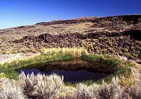 Malheur Maar, the only lake-filled maar in Diamond Craters | |
| Highest point | |
| Elevation | 4,707 ft (1,435 m) [1] |
| Coordinates | 43°06′N 118°45′W / 43.1°N 118.75°WCoordinates: 43°06′N 118°45′W / 43.1°N 118.75°W [1] |
| Geography | |
 Diamond Craters
| |
| Location | Harney County, Oregon, U.S. |
| Parent range | Basin and Range |
| Topo map | USGS Diamond Swamp |
| Geology | |
| Age of rock | 7320 to 7790 calendar years. B.P.[2] |
| Mountain type | Volcanic field / shield volcano |
| Climbing | |
| Easiest route | roads and trails |
Diamond Craters is a monogenetic volcanic field in southeastern Oregon, about 40 miles (64 km) southeast of the city of Burns. It consists of a 27-square-mile (70 km2) area of basaltic lava flows, cinder cones, and maars. The reexamination of radiocarbon dates from older studies and interpretation of paleomagnetic data and new radiocarbon dates limits the eruption of volcanic vents in this volcanic field to the time period between 7320 and 7790 calendar years B.P.[2]
Diamond Craters and the nearby Diamond post office were named after the Diamond Ranch, established in the area by the pioneer Mace McCoy. The ranch used a diamond-shaped brand, hence the name.[3]
In the 1970s, Diamond Craters was a source of controversy between the Bureau of Land Management and commercial stonecutters who were illegally removing slabs of lava to sell as veneer for fireplaces, home exteriors, and chimneys.[4] Geologists familiar with the area cited the craters' unusual research value, a "museum of basaltic volcanic features" apt to be destroyed by slab harvesting and associated heavy equipment.[4] In 1982, the area gained additional protection when it was designated an Outstanding Natural Area.[3]
Notable vents
| Name | Elevation | Coordinates | Last eruption |
| Big Bomb Crater[5] | 1,308 metres (4,291 ft) | - | - |
| Central Crater Complex[5] | 1,378 metres (4,521 ft) | - | - |
| Cloverleaf Crater | - | - | - |
| Dry Maar[5] | 1,268 metres (4,160 ft) | - | - |
| East Twin Crater[5] | 1,326 metres (4,350 ft) | - | - |
| Keyhole Explosion Crater[5] | - | - | - |
| Lava Pit Crater[5] | 1,305 metres (4,281 ft) | - | - |
| Little Red Cone | - | - | - |
| Malheur Maar[5] | 1,286 metres (4,219 ft) | - | - |
| Nolf Crater[5] | - | - | - |
| Oval Crater[5] | - | - | - |
| Red Bomb Crater[5] | 1,323 metres (4,341 ft) | - | - |
| West Twin Crater[5] | 1,326 metres (4,350 ft) | - | - |
References
- 1 2 "Diamond Craters". Global Volcanism Program. Smithsonian Institution.
- 1 2 Sherrod, D.R., D.E. Champion, and J.P. McGeehin (2012) Age and duration of volcanic activity at Diamond Craters, southeastern Oregon. Journal of Volcanology and Geothermal Research. 247–248:108–114
- 1 2 McArthur, Lewis A.; McArthur, Lewis L. (2003) [1928]. Oregon Geographic Names (7th ed.). Portland, Oregon: Oregon Historical Society Press. p. 286. ISBN 0-87595-277-1.
- 1 2 Hofferber, Connie (August 3, 1979). "BLM, Stonecutters Square Off Over Mining Diamond Craters". The Oregonian. p. 69. Retrieved January 4, 2016 – via NewsBank. (subscription required (help)).
- 1 2 3 4 5 6 7 8 9 10 11 "Diamond Craters - Synonyms and Subfeatures". Global Volcanism Program. Smithsonian Institution. Retrieved 2007-05-26.
External links
| Wikimedia Commons has media related to Diamond Craters. |
- Bureau of Land Management: Official Diamond Craters Outstanding Natural Area website
- Deschutes & Ochoco National Forests: Diamond Craters
- Volcano World.edu: Diamond Craters, Oregon
- Bureau of Land Management: "Diamond Craters Recreation Area Management Plan"