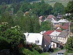
Domašov nad Bystřicí
| Domašov nad Bystřicí | ||
|---|---|---|
| Municipality | ||
 | ||
| ||
 Domašov nad Bystřicí | ||
| Coordinates: 49°44′18″N 17°26′36″E / 49.73833°N 17.44333°ECoordinates: 49°44′18″N 17°26′36″E / 49.73833°N 17.44333°E | ||
| Country |
| |
| Region | Olomouc | |
| District | Olomouc | |
| Area | ||
| • Total | 15.95 km2 (6.16 sq mi) | |
| Elevation | 510 m (1,670 ft) | |
| Population (2006) | ||
| • Total | 467 | |
| • Density | 29/km2 (76/sq mi) | |
| Postal code | 783 06 | |
| Website | http://www.domasovnadbystrici.cz | |

Domašov nad Bystřicí Czech pronunciation: [ˈdomaʃof ˈnadbɪstr̝̊ɪtsiː] (German: Domstadtl) is a village and municipality (obec) in Olomouc District in the Olomouc Region of the Czech Republic. The Battle of Domstadtl of the Seven Years' War took place near the village in 1758.
The municipality covers an area of 15.95 square kilometres (6.16 sq mi), and has a population of 467 (as at 3 July 2006).
Domašov nad Bystřicí lies approximately 22 kilometres (14 mi) north-east of Olomouc and 221 km (137 mi) east of Prague.
History
Until 1918, DOMSTADTL was part of the Austrian monarchy (Austria side after the compromise of 1867), in the Sternberg (Šternberk) district, one of the 34 Bezirkshauptmannschaften in Moravia.[1] A post-office was opened in 1869.
In 1938, after the Munich Agreement, it was occupied by the Nazi army as one of the municipalities in Sudetenland, one of the 6 towns of Landkreis Bärn.[2] The German speaking population was expelled in 1945 (further to the Beneš decrees) and replaced by Czech settlers, who renamed the village.
References
- ↑ Die postalischen Abstempelungen auf den österreichischen Postwertzeichen-Ausgaben 1867, 1883 und 1890, Wilhelm KLEIN, 1967
- ↑ Landkreis Bärn, German Wikipedia.
External links
| Wikimedia Commons has media related to Domašov nad Bystřicí. |