Dongo, Mali
| Dongo | |
|---|---|
| Commune | |
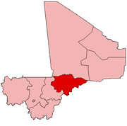
 Dongo Location in Mali | |
| Coordinates: 15°40′33″N 4°13′10″W / 15.67583°N 4.21944°WCoordinates: 15°40′33″N 4°13′10″W / 15.67583°N 4.21944°W | |
| Country |
|
| Region | Mopti Region |
| Cercle | Youwarou Cercle |
| Area | |
| • Total | 339 km2 (131 sq mi) |
| Population (2009 census)[1] | |
| • Total | 11,421 |
| • Density | 34/km2 (87/sq mi) |
| Time zone | GMT (UTC+0) |
Dongo is a commune of the Cercle of Youwarou in the Mopti Region of Mali. The principal village lies at Kormou-Marka. In 2009 the commune had a population of 11,421.
References
- ↑ Resultats Provisoires RGPH 2009 (Région de Mopti) (PDF) (in French), République de Mali: Institut National de la Statistique.
External links
- Plan de Sécurité Alimentaire Commune Rurale de Dongo 2006-2010 (PDF) (in French), Commissariat à la Sécurité Alimentaire, République du Mali, USAID-Mali, 2006.
This article is issued from Wikipedia - version of the 3/10/2013. The text is available under the Creative Commons Attribution/Share Alike but additional terms may apply for the media files.