Douglas County, Illinois
| Douglas County, Illinois | |
|---|---|
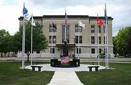 A veterans memorial on the east side of the courthouse | |
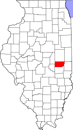 Location in the U.S. state of Illinois | |
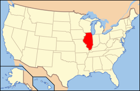 Illinois's location in the U.S. | |
| Founded | 1859 |
| Named for | Stephen A. Douglas |
| Seat | Tuscola |
| Largest city | Tuscola |
| Area | |
| • Total | 417 sq mi (1,080 km2) |
| • Land | 416 sq mi (1,077 km2) |
| • Water | 0.6 sq mi (2 km2), 0.1% |
| Population | |
| • (2010) | 19,980 |
| • Density | 48/sq mi (19/km²) |
| Congressional district | 15th |
| Time zone | Central: UTC-6/-5 |
Douglas County is a county located in the U.S. state of Illinois. As of the 2010 census, the population was 19,980.[1] The county seat is Tuscola.[2]
History
Douglas County was formed in 1859 out of Coles County. It was named in honor of Stephen A. Douglas,[3] who was elected to the United States Senate in 1858, following the Lincoln-Douglas Debates.
 The creation of Douglas and Ford Counties in 1859 resulted in Illinois' current county map.
Geography

According to the U.S. Census Bureau, the county has a total area of 417 square miles (1,080 km2), of which 417 square miles (1,080 km2) is land and 0.6 square miles (1.6 km2) (0.1%) is water.[4]
Climate and weather
| Tuscola, Illinois | ||||||||||||||||||||||||||||||||||||||||||||||||||||||||||||
|---|---|---|---|---|---|---|---|---|---|---|---|---|---|---|---|---|---|---|---|---|---|---|---|---|---|---|---|---|---|---|---|---|---|---|---|---|---|---|---|---|---|---|---|---|---|---|---|---|---|---|---|---|---|---|---|---|---|---|---|---|
| Climate chart (explanation) | ||||||||||||||||||||||||||||||||||||||||||||||||||||||||||||
| ||||||||||||||||||||||||||||||||||||||||||||||||||||||||||||
| ||||||||||||||||||||||||||||||||||||||||||||||||||||||||||||
In recent years, average temperatures in the county seat of Tuscola have ranged from a low of 18 °F (−8 °C) in January to a high of 88 °F (31 °C) in July, although a record low of −26 °F (−32 °C) was recorded in December 1989 and a record high of 113 °F (45 °C) was recorded in July 1954. Average monthly precipitation ranged from 2.12 inches (54 mm) in February to 4.64 inches (118 mm) in July.[5]
Adjacent counties
- Champaign County - north
- Vermilion County - northeast
- Edgar County - east
- Coles County - south
- Moultrie County - west
- Piatt County - northwest
Major highways
Demographics
| Historical population | |||
|---|---|---|---|
| Census | Pop. | %± | |
| 1860 | 7,140 | — | |
| 1870 | 13,484 | 88.9% | |
| 1880 | 15,853 | 17.6% | |
| 1890 | 17,669 | 11.5% | |
| 1900 | 19,097 | 8.1% | |
| 1910 | 19,591 | 2.6% | |
| 1920 | 19,604 | 0.1% | |
| 1930 | 17,914 | −8.6% | |
| 1940 | 17,590 | −1.8% | |
| 1950 | 16,706 | −5.0% | |
| 1960 | 19,243 | 15.2% | |
| 1970 | 18,997 | −1.3% | |
| 1980 | 19,774 | 4.1% | |
| 1990 | 19,464 | −1.6% | |
| 2000 | 19,922 | 2.4% | |
| 2010 | 19,980 | 0.3% | |
| Est. 2015 | 19,823 | [6] | −0.8% |
| U.S. Decennial Census[7] 1790-1960[8] 1900-1990[9] 1990-2000[10] 2010-2014[1] | |||
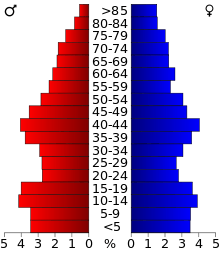
As of the 2010 United States Census, there were 19,980 people, 7,720 households, and 5,377 families residing in the county.[11] The population density was 48.0 inhabitants per square mile (18.5/km2). There were 8,390 housing units at an average density of 20.1 per square mile (7.8/km2).[4] The racial makeup of the county was 95.7% white, 0.4% Asian, 0.3% black or African American, 0.2% American Indian, 2.3% from other races, and 1.2% from two or more races. Those of Hispanic or Latino origin made up 6.1% of the population.[11] In terms of ancestry, 29.6% were German, 12.6% were American, 12.1% were English, and 10.7% were Irish.[12]
Of the 7,720 households, 32.6% had children under the age of 18 living with them, 57.0% were married couples living together, 8.5% had a female householder with no husband present, 30.3% were non-families, and 26.1% of all households were made up of individuals. The average household size was 2.57 and the average family size was 3.11. The median age was 38.7 years.[11]
The median income for a household in the county was $46,941 and the median income for a family was $60,352. Males had a median income of $41,318 versus $28,731 for females. The per capita income for the county was $21,438. About 7.1% of families and 10.2% of the population were below the poverty line, including 14.0% of those under age 18 and 7.2% of those age 65 or over.[13]
Communities

Cities
Villages
Unincorporated communities
- Hugo
- Kemp
Townships
Douglas County is divided into nine townships:
See also
References
- 1 2 "State & County QuickFacts". United States Census Bureau. Retrieved July 4, 2014.
- ↑ "Find a County". National Association of Counties. Retrieved 2011-06-07.
- ↑ Gannett, Henry (1905). The Origin of Certain Place Names in the United States. Govt. Print. Off. p. 108.
- 1 2 "Population, Housing Units, Area, and Density: 2010 - County". United States Census Bureau. Retrieved 2015-07-11.
- 1 2 "Monthly Averages for Tuscola, Illinois". The Weather Channel. Retrieved 2011-01-27.
- ↑ "County Totals Dataset: Population, Population Change and Estimated Components of Population Change: April 1, 2010 to July 1, 2015". Retrieved July 2, 2016.
- ↑ "U.S. Decennial Census". United States Census Bureau. Retrieved July 4, 2014.
- ↑ "Historical Census Browser". University of Virginia Library. Retrieved July 4, 2014.
- ↑ "Population of Counties by Decennial Census: 1900 to 1990". United States Census Bureau. Retrieved July 4, 2014.
- ↑ "Census 2000 PHC-T-4. Ranking Tables for Counties: 1990 and 2000" (PDF). United States Census Bureau. Retrieved July 4, 2014.
- 1 2 3 "DP-1 Profile of General Population and Housing Characteristics: 2010 Demographic Profile Data". United States Census Bureau. Retrieved 2015-07-11.
- ↑ "DP02 SELECTED SOCIAL CHARACTERISTICS IN THE UNITED STATES – 2006-2010 American Community Survey 5-Year Estimates". United States Census Bureau. Retrieved 2015-07-11.
- ↑ "DP03 SELECTED ECONOMIC CHARACTERISTICS – 2006-2010 American Community Survey 5-Year Estimates". United States Census Bureau. Retrieved 2015-07-11.
- United States Census Bureau 2007 TIGER/Line Shapefiles
- United States Board on Geographic Names (GNIS)
- United States National Atlas
External links
| Wikimedia Commons has media related to Douglas County, Illinois. |
 |
Piatt County | Champaign County | Vermilion County | |
| Moultrie County | |
Edgar County | ||
| ||||
| | ||||
| Coles County |
Municipalities and communities of Douglas County, Illinois, United States | ||
|---|---|---|
| Cities | ||
| Villages | ||
| Townships | ||
| Unincorporated communities | ||
| Ghost town | ||
| Footnotes | ‡This populated place also has portions in an adjacent county or counties | |

Coordinates: 39°46′N 88°13′W / 39.77°N 88.22°W