East Brady, Pennsylvania
| East Brady, Pennsylvania | ||
|---|---|---|
| Borough | ||
|
A street in East Brady | ||
| ||
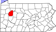 Map showing Clarion County in Pennsylvania | ||
 East Brady Location in Pennsylvania | ||
| Coordinates: 40°59′04″N 79°36′55″W / 40.98444°N 79.61528°WCoordinates: 40°59′04″N 79°36′55″W / 40.98444°N 79.61528°W | ||
| Country | United States | |
| State | Pennsylvania | |
| County | Clarion | |
| Settled | 1866 | |
| Incorporated | 1869 | |
| Government | ||
| • Type | Borough Council | |
| • Mayor | John Klein | |
| Area | ||
| • Total | 1.1 sq mi (2.9 km2) | |
| • Land | 0.8 sq mi (2.1 km2) | |
| • Water | 0.3 sq mi (0.8 km2) | |
| Elevation | 960 ft (290 m) | |
| Population (2010) | ||
| • Total | 942 | |
| • Density | 1,164/sq mi (449.6/km2) | |
| Time zone | Eastern (EST) (UTC-5) | |
| • Summer (DST) | EDT (UTC-4) | |
| ZIP code | 16028 | |
.jpg)
East Brady is a borough in Clarion County, Pennsylvania, United States. The population was 942 at the 2010 census.[1]
History
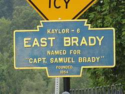
East Brady is named after Captain Samuel Brady, who battled Native Americans at that location.[2]
Geography
East Brady is located in the southwestern corner of Clarion County at 40°59′4″N 79°36′55″W / 40.98444°N 79.61528°W (40.984550, -79.615333),[3] on the east side of a bend in the Allegheny River, at a point 69 miles (111 km) upstream from the river's mouth in Pittsburgh. Pennsylvania Route 68 passes through the borough, crossing the Allegheny on the Sergeant Carl F. Curran II Bridge to Armstrong County and the community of Bradys Bend. PA 68 leads southwest 21 miles (34 km) to Butler and northeast 24 miles (39 km) to Clarion.
According to the United States Census Bureau, East Brady has a total area of 1.1 square miles (2.9 km2), of which 0.81 square miles (2.1 km2) is land and 0.31 square miles (0.8 km2), or 27.00%, is water.[1]
Demographics
| Historical population | |||
|---|---|---|---|
| Census | Pop. | %± | |
| 1870 | 728 | — | |
| 1880 | 1,242 | 70.6% | |
| 1890 | 1,228 | −1.1% | |
| 1900 | 1,233 | 0.4% | |
| 1910 | 1,493 | 21.1% | |
| 1920 | 1,531 | 2.5% | |
| 1930 | 1,563 | 2.1% | |
| 1940 | 1,427 | −8.7% | |
| 1950 | 1,400 | −1.9% | |
| 1960 | 1,282 | −8.4% | |
| 1970 | 1,218 | −5.0% | |
| 1980 | 1,153 | −5.3% | |
| 1990 | 1,047 | −9.2% | |
| 2000 | 1,038 | −0.9% | |
| 2010 | 942 | −9.2% | |
| Est. 2015 | 911 | [4] | −3.3% |
| Sources:[5][6][7] | |||
As of the census[6] of 2000, there were 1,038 people, 471 households, and 287 families residing in the borough. The population density was 1,233.6 people per square mile (477.1/km²). There were 542 housing units at an average density of 644.1 per square mile (249.1/km²). The racial makeup of the borough was 99.42% White, 0.10% Asian, and 0.48% from two or more races. Hispanic or Latino of any race were 0.29% of the population.
There were 471 households, out of which 24.0% had children under the age of 18 living with them, 48.6% were married couples living together, 8.5% had a female householder with no husband present, and 38.9% were non-families. 36.9% of all households were made up of individuals, and 24.6% had someone living alone who was 65 years of age or older. The average household size was 2.18 and the average family size was 2.81.
In the borough the population was spread out, with 19.3% under the age of 18, 7.1% from 18 to 24, 23.2% from 25 to 44, 23.5% from 45 to 64, and 26.9% who were 65 years of age or older. The median age was 45 years. For every 100 females there were 92.6 males. For every 100 females age 18 and over, there were 87.9 males.
The median income for a household in the borough was $26,667, and the median income for a family was $37,589. Males had a median income of $35,417 versus $21,538 for females. The per capita income for the borough was $15,299. About 10.9% of families and 11.8% of the population were below the poverty line, including 8.2% of those under age 18 and 17.7% of those age 65 or over.
Notable people
- Jim Kelly, former professional football player and Hall of Famer, Buffalo Bills
See also
References
| Wikimedia Commons has media related to East Brady, Pennsylvania. |
- 1 2 "Geographic Identifiers: 2010 Census Summary File 1 (G001): East Brady borough, Pennsylvania". U.S. Census Bureau, American Factfinder. Retrieved April 23, 2015.
- ↑ Egle, William H. An Illustrated History of the Commonwealth of Pennsylvania, Harrisburg: De Witt C. Goodrich & Co., 1876, p. 337
- ↑ "US Gazetteer files: 2010, 2000, and 1990". United States Census Bureau. 2011-02-12. Retrieved 2011-04-23.
- ↑ "Annual Estimates of the Resident Population for Incorporated Places: April 1, 2010 to July 1, 2015". Retrieved July 2, 2016.
- ↑ "Census of Population and Housing". U.S. Census Bureau. Retrieved 11 December 2013.
- 1 2 "American FactFinder". United States Census Bureau. Retrieved 2008-01-31.
- ↑ "Incorporated Places and Minor Civil Divisions Datasets: Subcounty Resident Population Estimates: April 1, 2010 to July 1, 2012". Population Estimates. U.S. Census Bureau. Retrieved 11 December 2013.
Municipalities and communities of Clarion County, Pennsylvania, United States | ||
|---|---|---|
| Boroughs | | |
| Townships | ||
| CDPs | ||
| Unincorporated communities | ||
| Footnotes | ‡This populated place also has portions in an adjacent county or counties | |