East Patchogue, New York
| East Patchogue | |
|---|---|
| Census-designated place | |
 | |
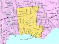 U.S. Census Map | |
| Coordinates: 40°46′6″N 72°58′59″W / 40.76833°N 72.98306°WCoordinates: 40°46′6″N 72°58′59″W / 40.76833°N 72.98306°W | |
| Country | United States |
| State | New York |
| County | Suffolk |
| Area | |
| • Total | 8.5 sq mi (21.9 km2) |
| • Land | 8.3 sq mi (21.5 km2) |
| • Water | 0.2 sq mi (0.4 km2) |
| Elevation | 23 ft (7 m) |
| Population (2010) | |
| • Total | 22,469 |
| • Density | 2,600/sq mi (1,000/km2) |
| Time zone | Eastern (EST) (UTC-5) |
| • Summer (DST) | EDT (UTC-4) |
| ZIP code | 11772 |
| Area code(s) | 631 |
| FIPS code | 36-22733 |
| GNIS feature ID | 0949199 |
East Patchogue is a census-designated place (CDP) in the Suffolk County town of Brookhaven, New York, United States. The population was 22,469 at the 2010 census.[1] The CDP is a proximate representation of the East Patchogue hamlet used for statistical purposes of the Census Bureau. East Patchogue is also the name given by the United States Postal Service for ZIP code 11772,[2] which serves the community.
East Patchogue is served by the Patchogue-Medford School District, except for eastern East Patchogue, which is served by the South Country Central School District.
The former East Patchogue post office was located at 1415 Montauk Highway, about five blocks east of the census map border.
Geography
According to the United States Census Bureau, the CDP has a total area of 8.5 square miles (22 km2), of which, 8.3 square miles (21 km2) of it is land and 0.2 square miles (0.52 km2) of it (1.89%) is water.
Demographics
As of the census[1] of 2000, there were 20,824 people, 7,493 households, and 5,297 families residing in the CDP. The population density was 2,503.9 per square mile (966.4/km²). There were 7,760 housing units at an average density of 933.1/sq mi (360.1/km²). The racial makeup of the CDP was 89.48% White, 3.19% African American, 0.14% Native American, 1.94% Asian, 0.01% Pacific Islander, 3.25% from other races, and 1.98% from two or more races. Hispanic or Latino of any race were 9.10% of the population.
There were 7,493 households out of which 31.4% had children under the age of 18 living with them, 56.6% were married couples living together, 9.6% had a female householder with no husband present, and 29.3% were non-families. 23.3% of all households were made up of individuals and 11.9% had someone living alone who was 65 years of age or older. The average household size was 2.71 and the average family size was 3.21.

In the CDP the population was spread out with 23.1% under the age of 18, 7.7% from 18 to 24, 30.4% from 25 to 44, 23.9% from 45 to 64, and 14.9% who were 65 years of age or older. The median age was 38 years. For every 100 females there were 94.8 males. For every 100 females age 18 and over, there were 90.9 males.
The median income for a household in the CDP was $57,237, and the median income for a family was $64,323. Males had a median income of $45,274 versus $31,704 for females. The per capita income for the CDP was $23,619. About 2.5% of families and 4.5% of the population were below the poverty line, including 4.0% of those under age 18 and 9.7% of those age 65 or over.
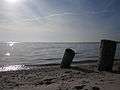
Pine Neck boat ramp

Pine Neck Avenue boat ramp and fishing pier are on the south shore of East Patchogue. Accessible by the Swan River at the south end of Pine Neck Avenue, this is a main boat access ramp off the Swan River inlet, connecting the Patchogue Bay and Great South Bay, in south central Long Island.
Pine Neck is approximately 400 yards (370 m) east of the Village of Patchogue, located on the south eastern corner of the Swan River inlet and Patchogue Bay. It is an undeveloped Park in the Township of Brookhaven, Suffolk County. Boaters travel from Blue Point, on the westernmost tip of Patchogue Bay, to Howell's Point, on the eastern side of the Bay. Seasonal permits are required for residents to launch their boats. The park can accommodate around 50 cars and trucks.
Pine Neck Avenue Park is on the central shore of Patchogue Bay, and is due north of Watch Hill and Davis Park. The Fire Island National Seashore is one of the Barrier Islands and is a recreational destination for many south shore boaters.
The Park offers a natural beach, fishing pier, two boat ramps, and an adjacent undeveloped shoreline called "40 acres". Pine Neck gives residents and visitors alike access and scenic views into Long Island's Great South Bay.
Notable people
- Daniel J. Bernstein, programmer, professor of mathematics and computer science
- Giovanni Capitello, filmmaker/actor - was born in Brooklyn, New York, but grew up in East Patchogue and attended Bellport High School. He still has family there.
- Irv Gordon, Guinness World Record holder and owner of the highest mileage non-commercial vehicle in history, a 1966 Volvo P1800 (1937) Lives in Patchogue.[3]
- Felix Grucci, United States Representative
- Neal Heaton, baseball player for New York Yankees (1993), lives in East Patchogue.
- Leila Kenzle, actress - was born in Patchogue (1961)
- Sylvia Porter, journalist - born in Patchogue (1913)
- Jeff Schaefer, baseball player for the Chicago White Sox (1989), born in Patchogue.
- Edgar A. Sharp, United States Representative - Republican to the Seventy-ninth Congress (1945-1947). Born in Patchogue.
See also
References
- 1 2 "American FactFinder". United States Census Bureau. Retrieved 2008-01-31.
- ↑ "ZIP code lookup - Search by city". United States Postal Service. Retrieved July 1, 2009.
|section=ignored (help) - ↑ He has done it! - Irv Gordon reaches 3 million miles in his 1966 Volvo 1800S (Volvo Car Group - Global Newsroom; September 19, 2013)
External links
- Pine Neck Avenue Boat Ramp (Long Island.com)
- Long Island Boat Ramps (Bayfisherman.com)
- Southern New York Boat Ramp list (The Fishing Line)
- New York State Department of Environmental Conservation