EskDale, Utah
| EskDale | |
|---|---|
| Unincorporated community | |
|
View of EskDale from the east | |
 EskDale  EskDale Location of EskDale in Utah | |
| Coordinates: 39°06′26″N 113°57′09″W / 39.10722°N 113.95250°WCoordinates: 39°06′26″N 113°57′09″W / 39.10722°N 113.95250°W | |
| Country | United States |
| State | Utah |
| County | Millard |
| Founded | 1955 |
| Named for | River Esk |
| Elevation[1] | 4,984 ft (1,519 m) |
| GNIS feature ID | 1427841[1] |

Eskdale (sometimes written as EskDale) is a small Unincorporated community farming commune in Millard County, Utah, located just east of the Nevada border. It is located in the southern part of Snake Valley, near the western flank of the Conger Range (part of the larger Confusion Range). It was founded in 1955 by Dr. M. L. Glendenning as a religious community of The Aaronic Order. The name itself comes from the River Esk in Scotland.[2]
The town is home to EskDale High School, which serves EskDale, Garrison, Utah, Burbank, Utah, and Baker, Nevada, along with other locals in the Snake Valley area. EskDale is also known for its dairy. In the 1990s and 2000s, EskDale is facing rapid population growth in a rural area that appears to be the ideal place for urban retirees from California.
References/Links
- 1 2 U.S. Geological Survey Geographic Names Information System: Eskdale
- ↑ Van Cott, John W. (1990). Utah Place Names. Salt Lake City: University of Utah Press. p. 131. ISBN 0-87480-345-4.
Municipalities and communities of Millard County, Utah, United States | ||
|---|---|---|
| Cities | 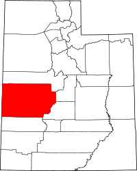 | |
| Towns | ||
| CDPs | ||
| Unincorporated communities | ||
| Ghost towns | ||