Francestown, New Hampshire
| Francestown, New Hampshire | |
|---|---|
| Town | |
|
| |
 Location in Hillsborough County, New Hampshire | |
| Coordinates: 42°59′15″N 71°48′45″W / 42.98750°N 71.81250°WCoordinates: 42°59′15″N 71°48′45″W / 42.98750°N 71.81250°W | |
| Country | United States |
| State | New Hampshire |
| County | Hillsborough |
| Incorporated | 1772 |
| Government | |
| • Board of Selectmen |
Brad Howell, Chair Abigail Arnold Henry Kunhardt |
| • Town Administrator | Jamie A. Pike |
| Area | |
| • Total | 30.7 sq mi (79.5 km2) |
| • Land | 30.2 sq mi (78.1 km2) |
| • Water | 0.5 sq mi (1.4 km2) 1.73% |
| Elevation | 831 ft (253 m) |
| Population (2010) | |
| • Total | 1,562 |
| • Density | 51/sq mi (20/km2) |
| Time zone | Eastern (UTC-5) |
| • Summer (DST) | Eastern (UTC-4) |
| ZIP code | 03043 |
| Area code(s) | 603 |
| FIPS code | 33-27140 |
| GNIS feature ID | 0873598 |
| Website |
www |
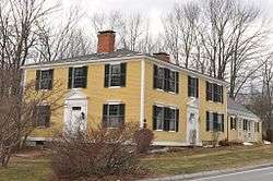
Francestown is a town in Hillsborough County, New Hampshire, United States. The population was 1,562 at the 2010 census.[1]
History
Incorporated in 1772, Francestown takes its name from Frances Deering Wentworth,[2] the wife of colonial governor John Wentworth. There were 928 residents when the first census was taken in 1790.[3] For some time the town used its location on the only route between Boston and Vermont, the Second New Hampshire Turnpike, to collect a toll of one cent per mile from coaches and wagons. High-quality soapstone was mined in Francestown until the 1890s.
Geography
According to the United States Census Bureau, the town has a total area of 30.7 square miles (80 km2), of which 30.2 square miles (78 km2) is land and 0.5 square miles (1.3 km2) is water, making up 1.73% of the town. The highest point in Francestown is the summit of Crotched Mountain, at 2,066 feet (630 m) above sea level, on the town's western border. Francestown lies fully within the Merrimack River watershed.[4]
Demographics
| Historical population | |||
|---|---|---|---|
| Census | Pop. | %± | |
| 1790 | 982 | — | |
| 1800 | 1,355 | 38.0% | |
| 1810 | 1,451 | 7.1% | |
| 1820 | 1,479 | 1.9% | |
| 1830 | 1,540 | 4.1% | |
| 1840 | 1,308 | −15.1% | |
| 1850 | 1,114 | −14.8% | |
| 1860 | 1,082 | −2.9% | |
| 1870 | 932 | −13.9% | |
| 1880 | 937 | 0.5% | |
| 1890 | 837 | −10.7% | |
| 1900 | 693 | −17.2% | |
| 1910 | 602 | −13.1% | |
| 1920 | 385 | −36.0% | |
| 1930 | 363 | −5.7% | |
| 1940 | 342 | −5.8% | |
| 1950 | 405 | 18.4% | |
| 1960 | 495 | 22.2% | |
| 1970 | 525 | 6.1% | |
| 1980 | 830 | 58.1% | |
| 1990 | 1,217 | 46.6% | |
| 2000 | 1,480 | 21.6% | |
| 2010 | 1,562 | 5.5% | |
| Est. 2015 | 1,571 | [5] | 0.6% |

As of the census[7] of 2000, there were 1,480 people, 552 households, and 418 families residing in the town. The population density was 49.1 people per square mile (18.9/km²). There were 656 housing units at an average density of 21.7 per square mile (8.4/km²). The racial makeup of the town was 97.30% White, 0.07% African American, 0.34% Native American, 0.27% Asian, 0.47% from other races, and 1.55% from two or more races. Hispanic or Latino of any race were 0.54% of the population.
There were 552 households out of which 34.6% had children under the age of 18 living with them, 66.8% were married couples living together, 6.0% had a female householder with no husband present, and 24.1% were non-families. 17.0% of all households were made up of individuals and 6.3% had someone living alone who was 65 years of age or older. The average household size was 2.68 and the average family size was 3.04.
In the town the population was spread out with 27.4% under the age of 18, 4.1% from 18 to 24, 28.7% from 25 to 44, 28.0% from 45 to 64, and 11.9% who were 65 years of age or older. The median age was 40 years. For every 100 females there were 103.9 males. For every 100 females age 18 and over, there were 99.8 males.
The median income for a household in the town was $64,259, and the median income for a family was $71,471. Males had a median income of $50,521 versus $32,778 for females. The per capita income for the town was $28,942. About 1.2% of families and 3.0% of the population were below the poverty line, including 2.5% of those under age 18 and 3.5% of those age 65 or over.
Notable people
- Samuel Bell, 14th governor of New Hampshire[8]
- Titus Brown, US congressman[9]
- Sylvester H. Roper, inventor; inducted into the Motorcycle Hall of Fame (2002)[10]
- Eri D. Woodbury, awarded the Medal of Honor for his actions during the Civil War.[11]
- Levi Woodbury, associate justice of the Supreme Court of the United States; 15th governor of New Hampshire[12]
References
| Wikimedia Commons has media related to Francestown, New Hampshire. |
- ↑ United States Census Bureau, American FactFinder, 2010 Census figures. Retrieved March 23, 2011.
- ↑ Gannett, Henry (1905). The Origin of Certain Place Names in the United States. Govt. Print. Off. p. 130.
- ↑ "Francestown". New Hampshire Economic and Labor Market Information Bureau Profile. Retrieved 25 April 2014.
- ↑ Foster, Debra H.; Batorfalvy, Tatianna N.; Medalie, Laura (1995). Water Use in New Hampshire: An Activities Guide for Teachers. U.S. Department of the Interior and U.S. Geological Survey.
- ↑ "Annual Estimates of the Resident Population for Incorporated Places: April 1, 2010 to July 1, 2015". Retrieved July 2, 2016.
- ↑ "Census of Population and Housing". Census.gov. Retrieved June 4, 2016.
- ↑ "American FactFinder". United States Census Bureau. Retrieved 2008-01-31.
- ↑ "BELL, Samuel, (1770 - 1850)". Biographical Directory of the United States Congress. Retrieved January 14, 2014.
- ↑ "BROWN, Titus, (1786 - 1849)". Biographical Directory of the United States Congress. Retrieved December 10, 2013.
- ↑ "Sylvester Roper". AMA Motorcycle Hall of Fame. Retrieved December 10, 2013.
- ↑ "Eri Davidson Woodbury". Military Times. Retrieved July 2014. Check date values in:
|access-date=(help) - ↑ "WOODBURY, Levi, (1789 - 1851)". Biographical Directory of the United States Congress. Retrieved December 10, 2013.
External links
- Town of Francestown official website
- New Hampshire Economic and Labor Market Information Bureau Profile
Municipalities and communities of Hillsborough County, New Hampshire, United States | ||
|---|---|---|
| Cities | 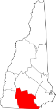 | |
| Towns | ||
| CDPs | ||
| Other villages | ||