Fuji, Shizuoka
| Fuji 富士市 | |||
|---|---|---|---|
| Special city | |||
|
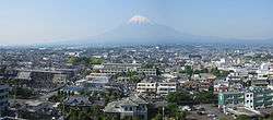
Mount Fuji and Fuji City seen from city hall | |||
| |||
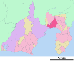 Location of Fuji in Shizuoka Prefecture | |||
 Fuji
| |||
| Coordinates: 35°9′40.8″N 138°40′34.6″E / 35.161333°N 138.676278°ECoordinates: 35°9′40.8″N 138°40′34.6″E / 35.161333°N 138.676278°E | |||
| Country | Japan | ||
| Region | Chūbu (Tōkai) | ||
| Prefecture | Shizuoka Prefecture | ||
| Government | |||
| • - Mayor | Hisashi Suzuki | ||
| Area | |||
| • Total | 244.95 km2 (94.58 sq mi) | ||
| Population (September 2015) | |||
| • Total | 249,535 | ||
| • Density | 1,020/km2 (2,600/sq mi) | ||
| Time zone | Japan Standard Time (UTC+9) | ||
| - Tree | Camphor Laurel | ||
| - Flower | Rose | ||
| Phone number | 0545-51-0123 | ||
| Address | 1-100 Nagatachō, Fuji-shi, Shizuoka-ken 417-8601 | ||
| Website | Official website | ||


Fuji (富士市 Fuji-shi) is a city in eastern Shizuoka Prefecture, Japan. Fuji is the third largest city in terms of population in Shizuoka Prefecture, trailing Hamamatsu and Shizuoka.
As of September 2015, the city had an estimated population of 249,535 and a population density of 1,020 persons per square kilometer (2,700/sq mi). The total area was 244.95 square kilometers (94.58 sq mi).
Geography
Located on the banks of the Fuji River, most of the city of Fuji enjoys good views of Mount Fuji, part of whose summit is within the city borders. The city is bordered to the south by Suruga Bay on the Pacific Ocean. The area enjoys a warm maritime climate with hot, humid summers and mild, cool winters.
Surrounding municipalities
- Shizuoka Prefecture
Climate
| Climate data for Fuji, Shizuoka | |||||||||||||
|---|---|---|---|---|---|---|---|---|---|---|---|---|---|
| Month | Jan | Feb | Mar | Apr | May | Jun | Jul | Aug | Sep | Oct | Nov | Dec | Year |
| Record high °C (°F) | 20.0 (68) |
23.8 (74.8) |
24.7 (76.5) |
27.7 (81.9) |
30.7 (87.3) |
34.2 (93.6) |
36.9 (98.4) |
35.4 (95.7) |
35.0 (95) |
31.1 (88) |
26.5 (79.7) |
24.2 (75.6) |
36.9 (98.4) |
| Average high °C (°F) | 11.1 (52) |
11.5 (52.7) |
14.3 (57.7) |
19.1 (66.4) |
22.7 (72.9) |
25.3 (77.5) |
28.8 (83.8) |
30.7 (87.3) |
27.8 (82) |
22.9 (73.2) |
18.1 (64.6) |
13.6 (56.5) |
20.5 (68.9) |
| Daily mean °C (°F) | 5.6 (42.1) |
6.3 (43.3) |
9.4 (48.9) |
14.3 (57.7) |
18.3 (64.9) |
21.5 (70.7) |
25.0 (77) |
26.5 (79.7) |
23.6 (74.5) |
18.2 (64.8) |
12.9 (55.2) |
8.0 (46.4) |
15.8 (60.4) |
| Average low °C (°F) | 1.0 (33.8) |
1.6 (34.9) |
4.8 (40.6) |
9.6 (49.3) |
14.2 (57.6) |
18.3 (64.9) |
22.2 (72) |
23.3 (73.9) |
20.2 (68.4) |
14.1 (57.4) |
8.5 (47.3) |
3.4 (38.1) |
11.8 (53.2) |
| Record low °C (°F) | −6.8 (19.8) |
−7.5 (18.5) |
−5.2 (22.6) |
−0.2 (31.6) |
5.8 (42.4) |
11.4 (52.5) |
14.1 (57.4) |
17.3 (63.1) |
10.5 (50.9) |
4.8 (40.6) |
−0.2 (31.6) |
−4.8 (23.4) |
−7.5 (18.5) |
| Average precipitation mm (inches) | 71.3 (2.807) |
93.4 (3.677) |
201.2 (7.921) |
178.6 (7.031) |
194.7 (7.665) |
259.5 (10.217) |
222.3 (8.752) |
226.5 (8.917) |
266.3 (10.484) |
198.7 (7.823) |
130.5 (5.138) |
66.3 (2.61) |
2,109.1 (83.035) |
| Mean monthly sunshine hours | 185.0 | 167.8 | 166.8 | 175.9 | 162.6 | 111.5 | 118.9 | 164.6 | 140.2 | 150.3 | 161.8 | 187.4 | 1,895.2 |
| Source #1: Japan Meteorological Agency(1981年-2010年)[1] | |||||||||||||
| Source #2: Japan Meteorological Agency(1978年-現在)[2] | |||||||||||||
History
In the Edo period, the Tōkaidō passed through the area that is now Fuji, with a post station at Yoshiwara-juku. During the Edo period, the area was mostly tenryō territory under direct control of the Tokugawa shogunate. During the cadastral reform of the early Meiji period in 1889, the area was reorganized into the town of Yoshiwara (吉原町) and the villages of Shimada (島田村) Denbō (伝法村), Imaizumi (今泉村), Motoyoshiwara (元吉原村), Sudo (須津村), Yoshinaga (吉永村), Harada (原田村), Ōbuchi (大淵村), Kajima (加島村), Tagoura (田子浦村), Iwamatsu (岩松村), and Takaoka (鷹岡村) within Fuji District.
Kajima became the town of Fuji on August 1, 1929. Neighboring Takaoka was elevated to town status on January 1, 1933. Shimada merged into Yoshiwara in 1940, Denbō in 1941, and Imaizumi in 1942. Yoshiwara was elevated to city status on April 1, 1948, the city expanded through annexation of Motoyoshiwara, Sudo, Yoshinaga, and Harada villages in 1955 and Ōbuchi in 1956.
Tagoura and Iwamatsu merged with Fuji to form the city of Fuji on March 31, 1954. The city expanded through annexation of neighboring Ukijima and San area from Hara, Suntō District in 1956.
On November 1, 1966, Fuji and Yoshiwara merged with Takaoka to form the new city of Fuji, which attained the status of a Special City on April 1, 2001 with greater autonomy from the central government.
On November 1, 2008, the town of Fujikawa (from Ihara District) was merged with Fuji.
Economy
Fuji is one of the major industrial centers of Shizuoka Prefecture, and the city has hosted numerous paper factories including Nippon Paper Industries (former Daishowa Paper Industries) and Oji Paper Company since the Meiji period. Other industries include food processing, metals and transportation equipment. Automobile parts manufacturer Jatco is headquartered in Fuji. Agriculture in the area is concentrated on green tea production and horticulture.
Education
- Tokoha University - Fuji campus
- Fuji has 27 elementary schools, 16 public and one private middle schools and two public and one private elementary school. In addition, the city has one special education school and one international school (Escola Fuji), a Brazilian primary school[3]
Transport
Railways
- JR Central - Tōkaidō Shinkansen
- JR Central - Tōkaidō Main Line
- JR Central - Minobu Line
- Gakunan Railway Line
- Yoshiwara - Jatco-mae - Yoshiwara-honchō - Hon-Yoshiwara - Gakunan-Harada - Hina - Gakunan-Fujioka - Sudo - Kamiya - Gakunan-Enoo
Highways
- Tōmei Expressway
- Nishi-Fuji Road
- Japan National Route 1
- Japan National Route 139
- Japan National Route 469
Ports
- Tagonoura Port
Local attractions


- The Bishamonten Festival is one of the three big Daruma festivals in Japan.
- The Yoshiwara Gion Festival is held on the second Saturday and Sunday of June.
- The Fuji Festival is held on the fourth Saturday of July.
- The Karigane Festival is held on the first Saturday of October.
Notable people from Fuji
- Yoji Totsuka - scientist
- Mitsuru Sugaya - manga artist
- Makoto Oishi - professional soccer player
- Yoshikatsu Kawaguchi - professional soccer player
- Takuro Kikuoka - professional soccer player
- Daigo Kobayashi - professional soccer player
- Shuji Kondo - professional wrestler
- Yukihiko Sato - professional soccer player
- Hiroyuki Shirai - professional soccer player
- Tatsuya Tsuruta - professional soccer player
Sister city
 - Oceanside, California, United States.[4]
References
- ↑ "平年値(年・月ごとの値)". JMA. Retrieved 2014-01-19.
- ↑ "観測史上1~10位の値(年間を通じての値)". JMA. Retrieved 2014-01-19.
- ↑ "Escolas Brasileiras Homologadas no Japão" (Archive). Embassy of Brazil in Tokyo. Retrieved on October 13, 2015.
- ↑ "Sister City Associations". Consulate-General of Japan in Los Angeles. Retrieved April 11, 2011.
External links
- Official website (Japanese)
![]() Media related to Fuji, Shizuoka at Wikimedia Commons
Media related to Fuji, Shizuoka at Wikimedia Commons
| Wards of Shizuoka | ||
|---|---|---|
| Wards of Hamamatsu | ||
| Special cities | ||
| Other cities | ||
| Kamo District | ||
| Tagata District | ||
| Suntō District | ||
| Haibara District | ||
| Shūchi District | ||