Arakawa, Tokyo
| Arakawa 荒川区 | |||
|---|---|---|---|
| Special ward | |||
| Arakawa City | |||
|
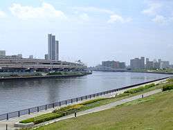
Sumida River from Suijin Bridge in Arakawa | |||
| |||
 Location of Arakawa in Tokyo Metropolis | |||
 Arakawa Location in Japan | |||
| Coordinates: 35°44′N 139°47′E / 35.733°N 139.783°ECoordinates: 35°44′N 139°47′E / 35.733°N 139.783°E | |||
| Country | Japan | ||
| Region | Kantō | ||
| Prefecture | Tokyo Metropolis | ||
| Government | |||
| • Mayor | Taichiro Nishikawa (since November 2004) | ||
| Area | |||
| • Total | 10.16 km2 (3.92 sq mi) | ||
| Population (May 1, 2015) | |||
| • Total | 208,763 | ||
| • Density | 20,550/km2 (53,200/sq mi) | ||
| Symbols | |||
| • Tree | Cherry blossom | ||
| • Flower | Azalea | ||
| Time zone | Japan Standard Time (UTC+9) | ||
| City hall address |
Arakawa 2-2-3, Arakawa, Tokyo 116-8501 | ||
| Website |
www | ||

Arakawa (荒川区 Arakawa-ku, "Raging River") is a special ward located in Tokyo Metropolis, Japan. The ward takes its name from the river, the Arakawa, though the Arakawa River does not run through or touch the ward. Its neighbors are the wards of Adachi, Kita, Bunkyo, Taito and Sumida. In English, the ward calls itself Arakawa City.
Arakawa has sister-city relationships with Donaustadt in Vienna, Austria, and with Corvallis, Oregon, U.S. Domestically, it has similar relationships with nine cities, towns and villages.
As of May 1, 2015, the ward has an estimated population of 208,763 and a population density of about 20,550 persons per km². The total area is 10.16 km².
Geography
Arakawa is in the northeastern part of Tokyo. The shape is long and narrow, stretching from west to east. The Sumida River forms the northern boundary.
The ward is surrounded by five other special wards. To the north lies Adachi; to the west, Kita; to the southwest, Bunkyo. South of Arakawa is Taito, and southeast is Sumida.
History
The area was mainly agricultural in the Edo period. In 1651, Kozukappara, the Tokugawa's largest execution ground (now located next to Minami-Senju station), was built. Beginning in the Meiji era, the area became industrial as factories were built on the water front.
In 1932, it became one of the 35 wards of Tokyo City.
Neighborhoods
- Machiya
- Arakawa
- Nishi-Ogu
- Nishi-Nippori
- Higashi-Ogu
- Higashi-Nippori
- Minami-Senju
Famous people
- Kosuke Kitajima (Olympic gold-medalist in swimming)
- Kanako Watanabe (Olympic athlete in swimming)
- Eiji Kosaka (Ward assembly member)
- Leopard Tamakuma (former WBA boxing flyweight champion)
- Hibari Misora (singer)
- Kuniko Yamada (comic)
- Momoe Yamaguchi (singer, actress)
- Eri Kamei (singer)
- Toru Yano (Professional wrestler)
Economy
MIAT Mongolian Airlines's Tokyo Branch Office is on the fifth floor in the Tachibana Building in Arakawa.[1]
Landmarks
Arakawa Nature Park
Education
Public elementary and middle schools are operated by the Arakawa City Board of Education.
Public high schools are operated by the Tokyo Metropolitan Government Board of Education.
The Tokyo First Korean Elementary and Junior High School (東京朝鮮第一初中級学校), a North Korean school, is in the ward.[4]
The metropolis operated the Tokyo Metropolitan College of Aeronautical Engineering (EN)[5][6] in Arakawa until 2010.
Transportation

Rail
- JR East
- Yamanote Line, Keihin Tohoku Line: Nishi Nippori, Nippori Stations
- Joban Line: Nippori, Mikawashima, Minami-Senju Stations
- Tokyo Metropolitan Bureau of Transportation
- Toden Arakawa Line (13 stations, including Minowabashi Station)
- Nippori-Toneri Liner: Nippori, Nishi-Nippori, Akado-Shōgakkō-mae, Kumano-mae
- Tokyo Metro
- Chiyoda Line: Nishi Nippori, Machiya Stations
- Hibiya Line: Minami Senju Station
- Keisei Electric Railway Keisei Main Line: Nippori, Shin-Mikawashima, Machiya Stations
- Metropolitan Intercity Railway Company Tsukuba Express: Minami-Senju Station
Additional facilities are under construction.
Major Roads
- Route 4 (the Nikkō Kaidō)
- Meiji Street
- Ogubashi Street
- Otakebashi Street
Events
- Sada Abe incident
- The attempted assassination of the head of the National Police Agency following an investigation of Aum Shinrikyo-related facilities (1995)
References
- ↑ "Contact Us." MIAT Mongolian Airlines. Retrieved on July 29, 2016. "TOKYO BRANCH OFFICE 5F, Tachibana Bldg, 2-19-4 Nishinippori, Arakawa-ku, Tokyo 116-0013, Japan "
- ↑ http://www.arakawakogyo-h.metro.tokyo.jp/
- ↑ http://www.takenodai-h.metro.tokyo.jp/
- ↑ "アクセス." Tokyo First Korean Elementary and Junior High School. Retrieved on October 13, 2015. "116-0014 東京都荒川区東日暮里3-8-5"
- ↑ "Tokyo Metropolitan College of Aeronautical Engineering". Tokyo Metropolitan College of Aeronautical Engineering. Archived from the original on 2009-03-09. Retrieved 2016-07-29.
- ↑ 東京都立航空工業高等専門学校 (in Japanese). 東京都立航空工業高等専門学校. Retrieved 2016-07-29.
External links
| Wikimedia Commons has media related to Arakawa, Tokyo. |
- Arakawa City official website (Japanese)
- Arakawa City official website (English, Chinese and Korean)