Gavrilovsky District
| Gavrilovsky District Гавриловский район (Russian) | |
|---|---|
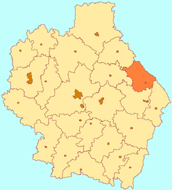 Location of Gavrilovsky District in Tambov Oblast | |
| Coordinates: 52°52′N 42°47′E / 52.867°N 42.783°ECoordinates: 52°52′N 42°47′E / 52.867°N 42.783°E | |
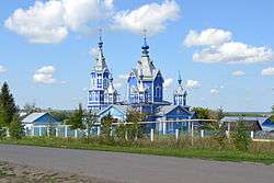 Wooden Church of the Theotokos of the Sign in Osino-Gay | |
| Location | |
| Country | Russia |
| Federal subject | Tambov Oblast[1] |
| Administrative structure (as of June 2015) | |
| Administrative center | selo of Gavrilovka 2-ya[1] |
| Administrative divisions:[1] | |
| Selsoviets | 6 |
| Inhabited localities:[1] | |
| Rural localities | 49 |
| Municipal structure (as of June 2015) | |
| Municipally incorporated as | Gavrilovsky Municipal District[2] |
| Municipal divisions:[2] | |
| Urban settlements | 0 |
| Rural settlements | 6 |
| Statistics | |
| Area | 998 km2 (385 sq mi)[3] |
| Population (2010 Census) | 12,032 inhabitants[4] |
| • Urban | 0% |
| • Rural | 100% |
| Density | 12.06/km2 (31.2/sq mi)[5] |
| Time zone | MSK (UTC+03:00)[6] |
| Official website | |
| Gavrilovsky District on WikiCommons | |
Gavrilovsky District (Russian: Гаври́ловский райо́н) is an administrative[1] and municipal[2] district (raion), one of the twenty-three in Tambov Oblast, Russia. It is located in the east of the oblast. The district borders with Pichayevsky District in the north, Belinsky District of Penza Oblast in the east, Kirsanovsky District in the south, and with Bondarsky District in the west. The area of the district is 998 square kilometers (385 sq mi).[3] Its administrative center is the rural locality (a selo) of Gavrilovka 2-ya.[1] Population: 12,032 (2010 Census);[4] 14,182 (2002 Census);[7] 15,528 (1989 Census).[8] The population of Gavrilovka 2-ya accounts for 22.2% of the district's total population.[4]
Geography
Gavrilovsky District is on the east-central side of Tambov Oblast, bordering on Penza Oblast. The district is about 70 km east of the city of Tambov, 50 km southeast of Morshansk, and 15 km north of Kirsanov. The Vorona River runs through the towards the south in the eastern sector of the district. The river ultimately empties into the Khopyor River and then the Don River. Gavrilovsky District is on the eastern edge of the Oka-Don Lowland, leading east into the Volga Uplands. The terrain is flat with draws and ravines, with steppe and forest-steppe vegetation.[9] The black soil of the district supports agriculture. The federal highway R-209 (Penza-Tambov) runs through the district.
The district measures about 40 km north-south and west-east. The administrative center of the district is the city of Gavrilovka 2-ya.
As of January, 2016, the three largest towns are Gavrilovka 2-ya (pop. 3,396), Peresypkinsky (pop. 2,313), and Kozmodemyanovsky (pop. 1,336).[10]
Climate
Average temperature in nearby Tambov in January is −10 °C (14 °F), and average July temperature is 20 °C (68 °F). Annual precipitation is 550 millimeters (22 in), and falls mostly in April through October.[11] The climate is Humid continental climate, cool summer, (Dfb). This climate is characterized by large swings in temperature, both diurnially and seasonally, with mild summers and cold, snowy winters.
Economy
Employment in the district is focused on food processing and agriculture.[12]
Agriculture
Gavrilovsky is an agricultural district, with farm revenues split about 30% crops and 70% livestock (including dairy). The most important grains are sunflower, barley, and wheat.[13] Approximately 49,319 hectares (50%) of the total area of the district is in cultivation for crops. In 2014, the top seven crops by area were:
| Crop | Cultivated Area (ha) | % of Culitvated Area |
|---|---|---|
| Sunflower grain | 15607 | 32 |
| Barley summer | 9333 | 19 |
| winter wheat | 8790 | 18 |
| spring wheat | 7076 | 14 |
| Sugar beet (factory) | 3951 | 8 |
| Peas | 1220 | 2 |
| Corn for grain | 982 | 2 |
References
- 1 2 3 4 5 6 Law #72-Z
- 1 2 3 Law #232-Z
- 1 2 "About the Area - Gavrilovsky District (Official Web Site)" (in Russian). Gavrilovsky District. Retrieved July 2, 2016.
- 1 2 3 Russian Federal State Statistics Service (2011). "Всероссийская перепись населения 2010 года. Том 1" [2010 All-Russian Population Census, vol. 1]. Всероссийская перепись населения 2010 года (2010 All-Russia Population Census) (in Russian). Federal State Statistics Service. Retrieved June 29, 2012.
- ↑ The value of density was calculated automatically by dividing the 2010 Census population by the area specified in the infobox. Please note that this value is only approximate as the area specified in the infobox does not necessarily correspond to the area of the entity proper or is reported for the same year as the population.
- ↑ Правительство Российской Федерации. Федеральный закон №107-ФЗ от 3 июня 2011 г. «Об исчислении времени», в ред. Федерального закона №271-ФЗ от 03 июля 2016 г. «О внесении изменений в Федеральный закон "Об исчислении времени"». Вступил в силу по истечении шестидесяти дней после дня официального опубликования (6 августа 2011 г.). Опубликован: "Российская газета", №120, 6 июня 2011 г. (Government of the Russian Federation. Federal Law #107-FZ of June 31, 2011 On Calculating Time, as amended by the Federal Law #271-FZ of July 03, 2016 On Amending Federal Law "On Calculating Time". Effective as of after sixty days following the day of the official publication.).
- ↑ Russian Federal State Statistics Service (May 21, 2004). "Численность населения России, субъектов Российской Федерации в составе федеральных округов, районов, городских поселений, сельских населённых пунктов – районных центров и сельских населённых пунктов с населением 3 тысячи и более человек" [Population of Russia, Its Federal Districts, Federal Subjects, Districts, Urban Localities, Rural Localities—Administrative Centers, and Rural Localities with Population of Over 3,000] (XLS). Всероссийская перепись населения 2002 года [All-Russia Population Census of 2002] (in Russian). Retrieved August 9, 2014.
- ↑ Demoscope Weekly (1989). "Всесоюзная перепись населения 1989 г. Численность наличного населения союзных и автономных республик, автономных областей и округов, краёв, областей, районов, городских поселений и сёл-райцентров" [All Union Population Census of 1989: Present Population of Union and Autonomous Republics, Autonomous Oblasts and Okrugs, Krais, Oblasts, Districts, Urban Settlements, and Villages Serving as District Administrative Centers]. Всесоюзная перепись населения 1989 года [All-Union Population Census of 1989] (in Russian). Институт демографии Национального исследовательского университета: Высшая школа экономики [Institute of Demography at the National Research University: Higher School of Economics]. Retrieved August 9, 2014.
- ↑ "About the region". Gavrilovsky District (Official website). Gavrilovsky District. Retrieved August 27, 2016.
- ↑ "Population of Municipalities in Tambov Region, January 1, 2016" (PDF) (in Russian). TERRITORIAL AUTHORITY OF THE FEDERAL SERVICE STATE STATISTICS for Tambov Region. Retrieved July 16, 2016.
- ↑ "Climate - Tambov". ClimateTemps. Climatetemps.com. Retrieved 27 August 2016.
- ↑ "Geogrpahical Position - Tambov". Tambov Investment. Tambov Oblast. Retrieved 27 August 2016.
- ↑ "Descriptive Statistics - Gavrilovsky" (in Russian). Federal State Statistics Service, Russian Federation. Retrieved July 2, 2016.
Sources
- Тамбовская областная Дума. Закон №72-З от 21 июня 1996 г. «Об административно-территориальном устройстве Тамбовской области», в ред. Закона №544-З от 11 июня 2015 г. «О внесении изменений в статью 7 Закона Тамбовской области "Об административно-территориальном устройстве Тамбовской области"». Опубликован: "Тамбовская жизнь", №131, 1996 г. (Tambov Oblast Duma. Law #72-Z of June 21, 1996 On the Administrative-Territorial Structure of Tambov Oblast, as amended by the Law #544-Z of June 11, 2015 On Amending Article 7 of the Law of Tambov Oblast "On the Administrative-Territorial Structure of Tambov Oblast". ).
- Тамбовская областная Дума. Закон №232-З от 17 сентября 2004 г. «Об установлении границ и определении места нахождения представительных органов муниципальных образований в Тамбовской области», в ред. Закона №606-З от 7 декабря 2015 г. «О внесении изменений в Закон Тамбовской области "Об установлении границ и определении места нахождения представительных органов муниципальных образований в Тамбовской области"». Вступил в силу со дня официального опубликования. Опубликован: "Тамбовская жизнь", №185 (23125). (Tambov Oblast Duma. Law #232-Z of September 17, 2004 On Establishing the Borders and Determining the Location of the Representative Organs of the Municipal Formations of Tambov Oblast, as amended by the Law #606-Z of December 7, 2015 On Amending the Law of Tambov Oblast "On Establishing the Borders and Determining the Location of the Representative Organs of the Municipal Formations of Tambov Oblast". Effective as of the official publication date.).
External links
- Gavrilovsky Official map of the district
- Gavrilovsky District on OpenStreetMap.org
- Gavrilovsky District on GoogleMaps
| Cities and towns | |||
|---|---|---|---|
| Districts | |||