Pichayevsky District
| Pichayevsky District Пичаевский район (Russian) | |
|---|---|
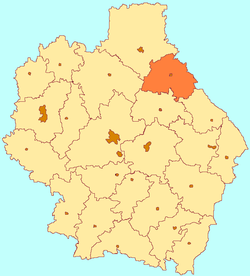 Location of Pichayevsky District in Tambov Oblast | |
| Coordinates: 53°14′06″N 42°12′06″E / 53.23500°N 42.20167°ECoordinates: 53°14′06″N 42°12′06″E / 53.23500°N 42.20167°E | |
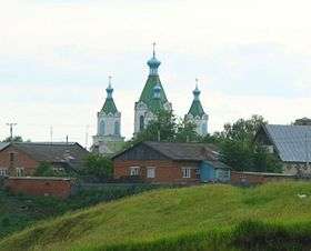
 Vernadovka Station, Syzran-Vyazma railway. | |
| Location | |
| Country | Russia |
| Federal subject | Tambov Oblast[1] |
| Administrative structure (as of April 2012) | |
| Administrative center | selo of Pichayevo[1] |
| Administrative divisions:[1] | |
| selsoviet | 10 |
| Inhabited localities:[1] | |
| Rural localities | 60 |
| Municipal structure (as of April 2012) | |
| Municipally incorporated as | Pichayevsky Municipal District[2] |
| Municipal divisions:[2] | |
| Urban settlements | 0 |
| Rural settlements | 10 |
| Statistics | |
| Area | 1,294 km2 (500 sq mi)[3] |
| Population (2010 Census) | 14,027 inhabitants[4] |
| • Urban | 0% |
| • Rural | 100% |
| Density | 10.84/km2 (28.1/sq mi)[5] |
| Time zone | MSK (UTC+03:00)[6] |
| Official website | |
| Pichayevsky District on WikiCommons | |
Pichayevsky District (Russian: Пича́евский райо́н) is an administrative[1] and municipal[2] district (raion), one of the twenty-three in Tambov Oblast, Russia. It is located in the northeast of the oblast. The district borders with Morshansky District in the north, Zemetchinsky District of Penza Oblast in the east, Bondarsky District in the south, and with Sosnovsky District in the west. The area of the district is 1,294 square kilometers (500 sq mi).[3] Its administrative center is the rural locality (a selo) of Pichayevo.[1] Population: 14,027 (2010 Census);[4] 16,542 (2002 Census);[7] 19,407 (1989 Census).[8] The population of Pichayevo accounts for 24.3% of the district's total population.[4]
Geography
Pichayevsky District is in the north-east of Tambov Oblast, about 50 km northeast of the city of Tambov, and 15 km southeast of Morshansk. Three rivers run south to north through the district: the Kersha, the Big Lomovis, and the Kashma.[9] 76.4% of the area is employed agriculture; the soils are chernozems (black earth). Forests cover 17.9% of territory (mostly on the west side), with cover of pine, oak, birch and aspen.
The district is roughly triangular in shape, measuring about 35 km north-south and 50 km west-east across the base. The administrative center of the district is the city of Pichaevo. Subdivisions of the district include 10 rural settlements.[9]
As of January, 2016, the three largest towns are Pichaevo (pop. 3,587), Baylovsky (pop. 1,443), and Lipovskii (pop. 1,244).[10] To the north, the area is bordered by Morshansky District, in the east by Bashmakovsky District in Penza Oblast, in the south by Bondarsky District and Gavrilovsky District, and in the west by Sosnovsky District.
Climate
Average January temperature in the district is −11 °C (12 °F), and average July temperature is 15.5 °C (59.9 °F). Annual precipitation is 475 millimeters (18.7 in)-500 millimeters (20 in), and falls mostly in April through October. The climate is Humid continental climate, cool summer, (Dfb). This climate is characterized by large swings in temperature, both diurnially and seasonally, with mild summers and cold, snowy winters. The growing season in Pichayevsky District lasts 179 to 182 days.
Economy
Employment in the district is focused on agriculture and light industry.
Transportation
The Murshansk-Syzran stretch of the Kuybyshev Railway runs across the northern tip of the district, with one station - the - within the boundaries. Another portion of the Kuyyshev runs through the northeast section, with a stop at the Vietinghoff station.
References
- 1 2 3 4 5 6 Law #72-Z
- 1 2 3 Law #232-Z
- 1 2 "District borders, Tambov Oblast, with area statistics (map)" (in Russian). Federal Statistics Service, Russian Federation. Retrieved July 17, 2016.
- 1 2 3 Russian Federal State Statistics Service (2011). "Всероссийская перепись населения 2010 года. Том 1" [2010 All-Russian Population Census, vol. 1]. Всероссийская перепись населения 2010 года (2010 All-Russia Population Census) (in Russian). Federal State Statistics Service. Retrieved June 29, 2012.
- ↑ The value of density was calculated automatically by dividing the 2010 Census population by the area specified in the infobox. Please note that this value is only approximate as the area specified in the infobox does not necessarily correspond to the area of the entity proper or is reported for the same year as the population.
- ↑ Правительство Российской Федерации. Федеральный закон №107-ФЗ от 3 июня 2011 г. «Об исчислении времени», в ред. Федерального закона №271-ФЗ от 03 июля 2016 г. «О внесении изменений в Федеральный закон "Об исчислении времени"». Вступил в силу по истечении шестидесяти дней после дня официального опубликования (6 августа 2011 г.). Опубликован: "Российская газета", №120, 6 июня 2011 г. (Government of the Russian Federation. Federal Law #107-FZ of June 31, 2011 On Calculating Time, as amended by the Federal Law #271-FZ of July 03, 2016 On Amending Federal Law "On Calculating Time". Effective as of after sixty days following the day of the official publication.).
- ↑ Russian Federal State Statistics Service (May 21, 2004). "Численность населения России, субъектов Российской Федерации в составе федеральных округов, районов, городских поселений, сельских населённых пунктов – районных центров и сельских населённых пунктов с населением 3 тысячи и более человек" [Population of Russia, Its Federal Districts, Federal Subjects, Districts, Urban Localities, Rural Localities—Administrative Centers, and Rural Localities with Population of Over 3,000] (XLS). Всероссийская перепись населения 2002 года [All-Russia Population Census of 2002] (in Russian). Retrieved August 9, 2014.
- ↑ Demoscope Weekly (1989). "Всесоюзная перепись населения 1989 г. Численность наличного населения союзных и автономных республик, автономных областей и округов, краёв, областей, районов, городских поселений и сёл-райцентров" [All Union Population Census of 1989: Present Population of Union and Autonomous Republics, Autonomous Oblasts and Okrugs, Krais, Oblasts, Districts, Urban Settlements, and Villages Serving as District Administrative Centers]. Всесоюзная перепись населения 1989 года [All-Union Population Census of 1989] (in Russian). Институт демографии Национального исследовательского университета: Высшая школа экономики [Institute of Demography at the National Research University: Higher School of Economics]. Retrieved August 9, 2014.
- 1 2 "About the region". Nikiforovsky District (Official website). Nikiforovsky District. Retrieved July 10, 2016.
- ↑ "Population of Municipalities in Tambov Region, January 1, 2016" (PDF) (in Russian). TERRITORIAL AUTHORITY OF THE FEDERAL SERVICE STATE STATISTICS for Tambov Region. Retrieved July 16, 2016.
Sources
- Тамбовская областная Дума. Закон №72-З от 21 июня 1996 г. «Об административно-территориальном устройстве Тамбовской области», в ред. Закона №544-З от 11 июня 2015 г. «О внесении изменений в статью 7 Закона Тамбовской области "Об административно-территориальном устройстве Тамбовской области"». Опубликован: "Тамбовская жизнь", №131, 1996 г. (Tambov Oblast Duma. Law #72-Z of June 21, 1996 On the Administrative-Territorial Structure of Tambov Oblast, as amended by the Law #544-Z of June 11, 2015 On Amending Article 7 of the Law of Tambov Oblast "On the Administrative-Territorial Structure of Tambov Oblast". ).
- Тамбовская областная Дума. Закон №232-З от 17 сентября 2004 г. «Об установлении границ и определении места нахождения представительных органов муниципальных образований в Тамбовской области», в ред. Закона №606-З от 7 декабря 2015 г. «О внесении изменений в Закон Тамбовской области "Об установлении границ и определении места нахождения представительных органов муниципальных образований в Тамбовской области"». Вступил в силу со дня официального опубликования. Опубликован: "Тамбовская жизнь", №185 (23125). (Tambov Oblast Duma. Law #232-Z of September 17, 2004 On Establishing the Borders and Determining the Location of the Representative Organs of the Municipal Formations of Tambov Oblast, as amended by the Law #606-Z of December 7, 2015 On Amending the Law of Tambov Oblast "On Establishing the Borders and Determining the Location of the Representative Organs of the Municipal Formations of Tambov Oblast". Effective as of the official publication date.).
External Links
| Cities and towns | |||
|---|---|---|---|
| Districts | |||