Gegharkunik Province
| Gegharkunik Գեղարքունիք | ||
|---|---|---|
| Province | ||
| ||
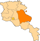
.svg.png) Location of Gegharkunik within Armenia | ||
| Coordinates: 40°25′N 45°12′E / 40.417°N 45.200°ECoordinates: 40°25′N 45°12′E / 40.417°N 45.200°E | ||
| Country | Armenia | |
| Capital and largest city | Gavar | |
| Government | ||
| • Governor | Nver Poghosian | |
| Area | ||
| • Total | 5,349 km2 (2,065 sq mi) | |
| Area rank | 1st | |
| Population (2011[1]) | ||
| • Total | 235,075 | |
| • Rank | 7th | |
| • Density | 44/km2 (110/sq mi) | |
| Time zone | AMT (UTC+04) | |
| Postal code | 1201–1626 | |
| ISO 3166 code | AM.GR | |
| FIPS 10-4 | AM04 | |
| Website | Official website | |
Gegharkunik (Armenian: Գեղարքունիք, Armenian pronunciation: [ɡɛʁɑɾkʰuˈnikʰ]), is a province (marz) of Armenia. Its capital and largest city is the town of Gavar.
Gegharkunik Province is located at the eastern part of Armenia, bordering Azerbaijan and the Shahumyan Region of Nagorno-Karabakh Republic. With an area of 5,348 km², Gegharkunik is the largest province in Armenia. However, approximately 1,278 km² of its territory is covered by Lake Sevan, the largest lake in the Caucasus and a major tourist attraction of the region.
The village of Artsvashen province has an exclave inside Azerbaijan is also a part of the province. However, it was attacked and forcefully occupied by Azerbaijan during the Nagorno-Karabakh War.
The Yerevan-Sevan-Dilijan republican highway runs through the province.
Etymology
| Part of a series on |
| Armenia Հայաստան |
|---|
  |
| Culture |
| History |
| Demographics |
| Administrative divisions |
|
| Armenia portal |
The name of Gegharkunik is derived from Gegham, a 5th-generation Haykazuni King and one of the descendants of the legendary patriarch and founder of the Armenian nation Hayk. Gegham was the father of Sisak (founder of the Siunia dynasty), and Harma (grandfather of Ara the Beautiful). Gegham mountains and the Lake of Gegham (currently known as Lake Sevan) were also named after Gegham.
Geography
Gegharkunik Province occupies the east of the central part of modern-day Armenia. With an area of 5,349 km² (18% of total area of Armenia), it is ranked first among the provinces of Armenia in terms of the total area.
Historically, the current territory of the province mainly occupies the Gegharkunik and Sotk cantons of Syunik province of Ancient Armenia, along with parts of Mazaz and Varazhnunik cantons of Ayrarat province.
Gegharkunik Province is situated at the east of modern-day Armenia, surrounding the Lake Sevan. Within the Republic of Armenia, it has borders with Tavush Province, Kotayk and Ararat provinces from the west and Vayots Dzor Province from the south. The Dashkasan and Gadabay districts of Azerbaijan, and the Shahumyan Region of Nagorno-Karabakh Republic form the eastern border of the province.
The Artsvashen Armenian exclave of Gegharkunik Province is currently occupied and controlled by Azerbaijan.
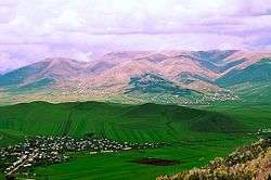
Gegharkunik has a mountainous landscape. The territory is dominated by the Gegham mountains from the west, the mountains of Vardenis from the south, Sevan mountains from the east, Miapor mountains from the northeast and the Kenats mountains from the north. The height of the mountains ranges between 2500 and 3500 meters.
%2C_Sevan_Botanical_Garden.jpg)
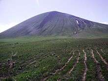
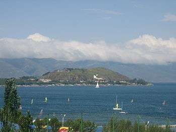
The highest point of the province is mount Azhdahak of the Gegham mountains with a height of 3597 meters at the western part of the range. Lake Sevan occupies the central part of the province, lying at a height of 1900 meters above sea level and covering an area of 1260 km².[2] (around 23.5% of the area of Gegharkunik).
Gegharkunik is separated from Vayots Dzor by the 82 kilometers-long Vardenis Mountains, where the highest point is Mount Vardenis at 3,522 meters.
The climate of Gegharkunik is cold and snowy in winter, while the summer is characterized with warm and humid climate. The annual precipitation level ranges between 500 and 600 mm at below 2000 meters, while it may reach up to 1000 mm in the mountainous areas.[3]
Lake Sevan is the largest body of sweet water in Armenia and Southern Cucasus. With a volume of around 32.92 billion m³ of water, Sevan is of a major environmental importance for the entire region.
Getik, Gavaraget and Masrik are the main rivers of the province.
History
From 1930 until 1995, modern-day Aragatsotn was divided into 5 raions within the Armenian SSR: Sevan raion, Kamo raion, Krasnoselsk raion, Kamo raion and Vardenis raion. With the territorial administration reform of 1995, the 5 raions were merged to form the Gegharkunik Province.
Demographics
Population
According to the 2011 official census, Gegharkunik has a population of 235,075 (119,180 men and 115,895 women), forming around 7.8% of the entire population of Armenia. The urban population is 71,423 (30.4%) and the rural is 163,652 (69.6%). The province has 5 urban and 87 rural communities. The largest urban community is the provincial centre of Gavar, with a population of 20,765. The other urban centres of are Sevan, Martuni, Vardenis and Chambarak.
With a population of 9,880, the village of Vardenik is the largest rural municipality of Gegharkunik. Vardenik is also the largest rural community in Armenia.
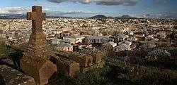
Ethnic groups and religion
.jpg)
Gegharkunik Province is almost entirely populated by ethnic Armenians who belong to the Armenian Apostolic Church. The regulating body of the church is the Diocese of Gegharkunik, headed by Bishop Markos Hovhannisyan. The Holy Mother of God Cathedral in Gavar is the seat of the diocese.
In 1992, the Artsvashen exclave was occupied by Azerbaijan and resettled by Azerbaijanis.
The villages of Chkalovka (formerly Aleksandrovka) and Semyonovka were founded by Russian Molokans during the 1st half of the 19th century. Currently, very few Molokans are still residing in the 2 villages.
The regions of Vardenis and Chambarak used to have a significant minority of Azerbaijani population. However, after the break-out of the Nagorno-Karabakh War in 1988, the Azerbaijanis were expelled and replaced by Armenian refugees who were displaced from several regions of Azerbaijan.
Culture
There are cultural palaces and many public libraries in the urban settlements of the province. A geological museum operates in Sevan on the basis of the Sevan Botanical Garden. Gavar is home to a history museum as well as drama theatre.
The cuisine of Gavar is closely related with the oriental cuisine elements, characterized with various spices, vegetables, fish, and fruits combination. One of the famous sweets of the town is the Kyavar baklava which is a many-layered pastry with tissue-thin sheets of phyllo dough, filled with nuts and sugar and finished with a dousing of hot honey.
The summer presidential residence of the Republic of Armenia is located at the Sevan Peninsula.
Fortresses and archaeological sites
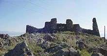
- Mount Azhdahak Petroglyphs: A great number of prehistoric petroglyphs have been found in the surroundings of Mount Azhdahak. Most images depict men in scenes of hunting and fighting, as well as astronomical bodies and phenomena: the Sun, the Moon, constellations, the stellar sky, lightning, and many others.
- Lchashen Cyclopean Fortress: the site is home to an ancient settlement, a burial place and a cyclopean fortress dating back to the 4rth millennium-7th century BC.
- Sevsar Ancient Astronomical Observatory: at the western slopes of Mount Sevsar, dating back to the 3rd-1st millennia BC. Recent studies suggest the birthplace of the naming of the constellations and the creation of the zodiac is in the Armenian plateau.
- Berdkunk Fortress of the 1st millennium BC,
- Teyseba archaeological site of the Urartian period, 8th century BC,
- Odzaberd fortress, 8th century BC,
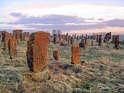
- Noratus cemetery of the 10th century.
Churches and monasteries
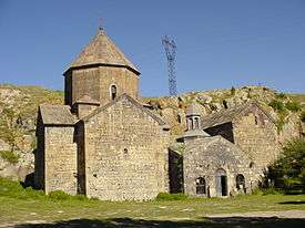
- Shoghagavank Monastery of the 5th century
- Saint Thaddeus Church of Ddmashen, 7th century,
- Hatsarat Monastery of the 7th century,
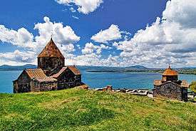
- Sevanavank monastic complex of the 9th century,
- Hayravank Monastery of the 9th century,
- Makenyats Vank monastic complex of the 9th century,
- Kotavank monastery of the Holy Mother of God, 9th century,
- Surp Hovhannes Church of Tsaghkashen, 9th century,
- Shoghagavank monastic complex of the 9th century,
- Vanevan Monastery opened in 903.
Media
Gegharkunik has 4 regional TV stations:
- Zangak TV, based in Martuni, operating since 1996.
- Kyavar TV, based in Gavar, operating since 1997.
- Sevan TV (STV 1), based in Sevan, operating since 1999.
- Geghama TV, based in Sevan, operating since 2010.
Transportation
The province is connected with other parts of Armenia through the M-4, M-10 and M-14 Motorways. The M-11 Motorway that passes through Martuni and Vardenis, connects the province with the town of Karvachar of the Nagorno-Karabakh Republic.
Sevan has a train station that connects the town with Yerevan through railway. The provincial centre Gavar has an airstrip since the Soviet years, located to the north of the town.
Economy
Agriculture
.JPG)
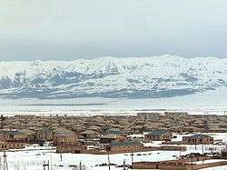
The economy of Gegharkunik Province has a predominantly agricultural orientation, including farming and cattle-breeding. It has a share of 18% in the annual total agricultural product of Armenia. Around 65% (3,487 km²) of the total area of the province are arable lands, out of which 27.3% (951.5 km²) are ploughed.[4] Around 60,000 farms in Gegharkunik are operated by the private sector. The main crops are potato and grains.
Fishing and fish farming is also dominant in the province. Recently, beekeeping has significantly developed.
Industry
Generally, Gegharkunik has a poor industrial index with a small number of operating firms. Currently, the province has a contribution of only 2% in the annual total industrial product of Armenia.
- The Sotk gold mine near Vardenis has one of the largest gold deposits in Armenia. It is owned and operated by the "GeoProMining Gold" company. The town of Vardenis is home to the "Samelon Vardenis Sea-Buckthorn Processing Plant" for alcoholic beverages and soft drinks, founded in 2000. It is also home to the "Gnel Khachatryan" plant for dairy products, as well as many small furniture manufacturing plants.
- The town of Sevan is home to the beer manufacturers "Lihnitis Sevan Brewery" founded in 2007, with a variety of lager beer under the brand "Kellers". It is also home to the Sevan bread and bakery factory operating since 1947, as well as the Sevan Sugar Plant founded in 2003. The "Yerknain Manana" confectionery plant and the "Tuff-Granite" mining plant are also based in Sevan.
- Gavar is home to the "Gavar Furniture Factory" since 1948, the "Sevan Mineral Water Plant" founded in 1953 (reopened in 2015), the "Aquatic LLC" for processed crayfish founded in 2002, the "Kirakosyan" furniture factory founded in 2006, the "Shushan Production Cooperative" for soft drinks, "Artsrun and Sons" for dairy products in Martuni village, and the "Atast Food" in Verin Getashen.
- Chambarak is home to the Chambarak Cheese Factory as well as the "La-Mar Stone Mining" plant. Martuni is home to the "Arev-1" bread factory (since 1995), and the "Golden Lens" coffee processing plant (since 1998).
- The village of Karmirgyugh is home to the "Yengoyan" carpet factory founded in 1958 (privatized in 1996). The "Arax-2 Production Cooperative" for dairy products is operating in the village of Akunk since 1996. The "Tarzu-Levon" factory for soft drinks is operating in Dzovazard village since 1999. The "AMA Compressor LLC" for industrial equipments is operating in the village of Gagarin since 2003. The "Sahakyan LLC" smart systems manufacturers are operating in Ddmashen village since 2012.
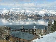
Tourism
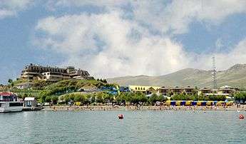
.jpg)
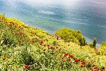
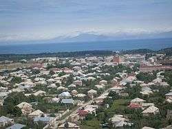
Tourism services in Gegharkunik are seasonal. The towns of Sevan, Chambarak and Martuni along with their surrounding beaches are a major summer destination for locals and foreigners with many hotels and resorts. The cultural heritage and the natural monuments of the region attract the tourists too.
During the last decade, many new hotels and spa resorts were opened along the coast of Lake Sevan, including the Harsnaqar Hotel and Water Park, the Best Western Bohemian Resort Sevan, the Akhtamar Sevan Hotel, the Tufenkian Avan Marag Hotel of Tsapatagh, the Blue Sevan Rest-house near Tsovagyugh, the Maria Resort Sevan and the Lavanda City cottages.
In February 2011, the Sevan ropeway was opened at the north of the town, in the area known as "mashtotsner", on the way to Tsovagyugh village. It has a length of 1,130 meters.[5]
Many forests of the province are listed among the protected areas of Armenia, including the Sevan National Park, the Getik Sanctuary, and the Juniper Woodlands Sanctuary of the mountains of Sevan. The Sevan Botanical Garden is also a major destination for the lovers of ecotourism.
Education
As of 2016, Gegharkunik Province has 126 public schools.[6]
Three major educational institutions currently operating in Gegharkunik are:
- The Gavar State University was opened in 1993 after the independence of Armenia. With its five faculties the university is a major educational centre for the entire province of Gegharkunik. It provides degrees in Philology, Natural Sciences, Humanities, Economics and Education. Nowadays, more than 2,400 students are attending the university.
- The Gavar Special School is the only school for mentally and physically handicapped children in the region. It is currently carrying out steps towards improvement and development with the assistance of its partners and sponsors on its way to become a leading institution among the special schools in Armenia.
- The Vaskenian Theological Academy on the Sevan peninsula is a leading institution of theological studies, Armenian literature, history, art, liturgy and traditions of the Armenian Church.
Sport
During the brief summer of the region, Sevan and the nearby beaches tun into a popular beach resort. Many professionals and amateurs visit the region to practice their favourite types of sports including beach soccer, beach volleyball and windsurfing.
The defunct football teams of FC Akhtamar Sevan and Lernagorts Vardenis FC represented the province at the domestic competitions during the 1990s. Alashkert FC represented town of Martuni between 1990 and 2000 before being relocated to Yerevan.
There are football stadiums in Martuni, Vardenis and the village of Lchashen.
Communities
The province of Gegharkunik consists of the following 92 communities (hamaynkner), of which 5 are considered urban and 87 are considered rural.[7]
Towns or urban communities
| Image | City (town) | Province | Founded | Land area (km2) | Population (2011 census) |
Population (2016 estimate) |
|---|---|---|---|---|---|---|
 | Chambarak | Gegharkunik | 1830s | 6 | 5,850 | 5,700 |
 | Gavar | Gegharkunik | 1830 | 16 | 20,765 | 19,500 |
 | Martuni | Gegharkunik | 1830 | 10 | 12,894 | 12,200 |
 | Sevan | Gegharkunik | 1842 | 17.75 | 19,229 | 19,200 |
 | Vardenis | Gegharkunik | 1830 | 10 | 12,685 | 12,600 |
Villages or rural communities
Non-community villages
- Barepat, belongs to the Kalavan community.
- Gagarin, belongs to the Sevan community.
- Lernahovit, belongs to the Geghhovit community.
Former villages
- Chapkut, belongs to the Aygut community.
- Nshkhark, belongs to the Geghhovit community.
- Zariver, belongs to the Kutakan community.
Gallery
- Gegharkunik
 Sevanavank, 874 AD
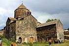 Makenyats Vank, 9th century
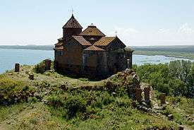 Hayravank, 9th century
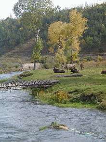 Getik River and sanctuary
.jpg) Spring in Gegharkunik
Spring in Gegharkunik
See also
References
- ↑ Gegharkunik population, 2011 census
- ↑ Gegharkunik agroweb
- ↑ Lake Sevan
- ↑ Armstat, Gegharkunik Province
- ↑ The new ropeway of Sevan will be opened on 15 February 2011
- ↑ Gegharkunik Province schools
- ↑ "RA Gegharkunik Marz" (PDF). Marzes of the Republic of Armenia in Figures, 2002–2006. National Statistical Service of the Republic of Armenia. 2007.
External links
| Wikimedia Commons has media related to Gegharkunik Province. |
| Provinces (մարզեր) | ||
|---|---|---|
| City with special status |
| |