Golden Corridor
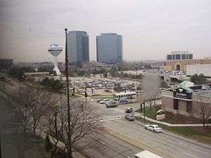
The Golden Corridor is the area around the Jane Addams Memorial Tollway (Interstate 90), formerly known as the Northwest Tollway, in the Chicago metropolitan area.[1] It is coined as such since the corridor generates a "gold" mine of economic profit for communities in the area. Several Fortune 500 company headquarters, office parks, industrial parks, exhibition and entertainment centers, medical facilities, hotels, shopping centers, and restaurants are located along the Golden Corridor. With the exception of the O'Hare area of Chicago, all of the communities located in this region are part of a larger region known as the "Northwest Suburbs".
Cities and villages
Cities and villages located within the scope of the Golden Corridor include:
- Chicago (O'Hare community area)
- Rosemont
- Park Ridge
- Des Plaines
- Norridge
- Mount Prospect
- Arlington Heights
- Elk Grove Village
- Franklin Park
- Bensenville
- Wood Dale
- Itasca
- Roselle
- Schaumburg
- Prospect Heights
- Hoffman Estates
- Rolling Meadows
- Palatine
- South Barrington
- Streamwood
- Hanover Park
- Bartlett
- South Elgin
- Elgin
- East Dundee
- West Dundee
- Sleepy Hollow
- Gilberts
- Carpentersville
- Algonquin
- Lake in the Hills
- Huntley
- Hampshire
- Pingree Grove
- Marengo
Major companies
Several important companies are headquartered in or have a significant presence in the corridor. They include:
- Sears Holdings, a major department store chain headquartered in Hoffman Estates
- Motorola Solutions, a telecommunications company headquartered in Schaumburg
- United Airlines, a major airline houses its data center in Elk Grove Township. (Its headquarters are in Chicago)
- Claire's, a retailer of accessories and jewelry to young women, headquartered in Hoffman Estates
- Affiliated Computer Services, an information technology outsourcing company with offices in Schaumburg
- The Nielsen Company, a marketing research firm headquartered in Schaumburg
- Automatic Data Processing, a technology and services company whose Dealer Services Division is headquartered in Hoffman Estates
- U.S. Robotics, a manufacturer of modems headquartered in Schaumburg
- United Stationers, an office products distributor headquartered in Des Plaines
- Big Ten Conference, a collegiate athletics conference headquartered in Rosemont
- Popular, Inc., regional offices in Rosemont
- Sprint Nextel, a telecommunications company with regional offices in Rosemont and Itasca
- Nexicore, a Nationwide onsite computer contractor with offices in Des Plaines
- Zurich Insurance Group, North America headquarters in Schaumburg
- Fifth Third Bank branch offices in the Continental Towers in Arlington Heights
- Chase Bank branch offices in Elgin
- AT&T, telecommunications company with a large regional office in Hoffman Estates
- Evangelical Covenant Church, a Protestant religious denomination headquartered in Chicago (O'Hare community area)
- Evangelical Lutheran Church in America, a Protestant religious denomination headquartered in Chicago (O'Hare community area)
- IGA, a supermarket chain headquartered in Chicago (O'Hare community area)
- True Value, a hardware store chain headquartered in Chicago (O'Hare community area)
- U.S. Cellular, a mobile communications service provider headquartered in Chicago (O'Hare community area)
- uBid, an online auction platform company headquartered in Chicago (O'Hare community area)
- XL Capital, A Corporate Insurance Company headquartered in Bermuda, Has Regional offices in Schaumburg
- Siemens Medical Solutions, regional offices in Hoffman Estates
- FANUC Robotics, regional offices in Hoffman Estates
- Mori Seiki, U.S. headquarters in Rolling Meadows
- NEC Display Solutions of America, regional offices in Itasca
- Omron, regional offices in Schaumburg
- STMicroelectronics, regional offices in Schaumburg
- Mazak, a Japanese machine tool builder with regional offices in Schaumburg and Elgin
- THK, a Japanese machinery manufacturer with its U.S. headquarters in Schaumburg
- First Midwest Bank, a bank headquartered in Itasca
- BMO Harris Bank, a Chicago-based bank with regional offices in Schaumburg
- Comcast, a cable and telecommunications provider with regional offices in Schaumburg
- Chicago Tribune, a Chicago-based newspaper with regional offices in Schaumburg
- The Daily Herald, a suburban Chicago newspaper with headquarters in Arlington Heights and regional offices in Elgin and a printing center in Schaumburg
- Verizon Wireless, a telecommunications company with regional offices in Elgin
- Safeco, an insurance company with regional offices in Schaumburg
- Experian (EMS - Experian Marketing Services) a credit information group with regional offices in Schaumburg
- CareerBuilder.com, a career services company headquartered in Chicago (O'Hare community area)
- Pace, suburban Chicago's bus transit provider headquartered in Arlington Heights
- PromoWorks, a marketing services company headquartered in Schaumburg
- Weber-Stephen Products headquarters in Palatine, Illinois and factory in Huntley
- Regional offices for several major home developers including Pulte and Lennar
- InstallShield, A Software Company for developing Software Installation Programs, with Headquarters in Schaumburg
- Expansive industrial parks in Elk Grove Village and Elgin
- Great American Insurance Company, an insurance company with divisions in Schaumburg
- BMW of North America, a German luxury auto manufacturer, with Regional offices in Schaumburg
- Schaumburg Boomers, a professional minor league baseball team located in Schaumburg
Educational institutions
A variety of higher educational institutions are located along the Golden Corridor, ranging from branch locations to community colleges to four year colleges.
- Judson University, a 4-year college located in Elgin
- Harper College, a very large community college located at Roselle Road and Algonquin Road in Palatine
- Elgin Community College, a community college in Elgin
- Roosevelt University on McConnor Parkway in Schaumburg
- NIU Hoffman Estates, the Hoffman Estates branch of Northern Illinois University, located at Beverly Road and I-90
- American InterContinental University has its online campus offices in Schaumburg
- Argosy University branch in Schaumburg
- DePaul University branch in Rolling Meadows
- Olivet Nazarene University branch in Rolling Meadows
- National Louis University branch in Elgin
- Illinois Institute of Art in Schaumburg
- Oakton Community College in Des Plaines
Shopping centers

Ranging from regional indoor malls to chic lifestyle centers, "the Golden Corridor" is a bustling center of retail activity. Major shopping centers include:
- Woodfield Mall, among the Top 10 largest malls in North America, and the largest in Illinois. Located at Golf Road and Interstate 290, just south of Interstate 90
- The Streets of Woodfield, an outdoor mall of about 30 stores adjacent to Woodfield Mall.
- Fashion Outlets of Chicago, an enclosed 130-store outlet mall located at River Road and Balmoral Avenue, on the east side of Interstate 294, just south of Interstate 90 and Interstate 190, in Rosemont
- Huntley Prime Outlets, a 4-store outlet mall located at Route 47 and I-90 in Huntley
- Algonquin Commons and the Algonquin Galleria, the largest outdoor mall complex in Illinois. Located on Randall Road, 5 miles (8.0 km) north of I-90, in Algonquin
- Spring Hill Mall, a regional mall at Route 31 and Route 72, 2 miles (3.2 km) north of I-90, in West Dundee
- The Arboretum of South Barrington located in South Barrington, off of Illinois Route 59 and Illinois Route 72.
- One of two Chicago-area IKEA locations in Schaumburg
- Cabela's in Hoffman Estates
Entertainment and exhibition centers
From major arenas to convention centers to theaters to gambling centers, the Golden Corridor is a thriving entertainment center. Major facilities include:
- Allstate Arena, a 16,000 seat arena at Mannheim Road and Interstate 90 in Rosemont. The arena is the home of the Chicago Wolves AHL team, Chicago Sky WNBA team, and DePaul Blue Demons college basketball team.
- Sears Centre, a 10,000 seat arena at Beverly Road and Interstate 90 in Hoffman Estates. The arena is the home of the Chicago Mustangs MASL team.
- The Rosemont Theater, a 4,000 seat theater in Rosemont.
- The Hemmens Cultural Center, a 1,200 seat theater in downtown Elgin. The theater is the home of the Elgin Symphony Orchestra.
- The Donald E. Stephens Convention Center, an 840,000-square-foot (78,000 m2) convention center in Rosemont.
- Schaumburg Convention Center and Renaissance Hotel, a 175,000-square-foot (16,300 m2) convention center and 500-room hotel located at Meacham Road and I-90 in Schaumburg.
- Medieval Times, a dinner-theater located at Roselle Road and Interstate 90 in Schaumburg.
- Legoland Discovery Center in Schaumburg.
- Arlington Park, a major horse racing track in Arlington Heights, along Illinois Route 53, just 2 miles (3.2 km) north of Interstate 90.
- Grand Victoria Riverboat, located in downtown Elgin, a couple miles south of Interstate 90.
- Rivers Casino, a casino located at River Road and Devon Avenue in Des Plaines, on the east side of Interstate 294, just north of Interstate 90. It is Illinois' most-profitable casino.
- The Schaumburg Baseball Stadium, a 7,000+ seat minor league ballpark located on Springinsguth Road in Schaumburg, a few miles south of Interstate 90. It is home of the Schaumburg Boomers professional minor league baseball team.
Healthcare facilities
Located within five miles (8 km) of the Northwest Tollway are a variety of major hospitals, including:
- Sherman Hospital: off Randall Road, a half-mile south of Interstate 90 in Elgin
- St. Joseph's Hospital: off Randall Road, 3 miles (4.8 km) south of Interstate 90 in Elgin
- St. Alexius Hospital: on Barrington Road, a half-mile south of Interstate 90 in Hoffman Estates
- Northwest Community Hospital: off Central Road, a mile north of Interstate 90 in Arlington Heights
- Alexian Brothers Hospital: on Biesterfield Road, 3 miles (4.8 km) south of Interstate 90 in Elk Grove Village
- Advocate Lutheran General Hospital: a major hospital and trauma center on Dempster Street, 4 miles (6.4 km) north of Interstate 90 in Park Ridge
Hotels and restaurants
Nearly every national hotel and restaurant chain can be found along the corridor, as well as numerous independently owned and local chains.
The highest concentration of hotels can be found in the Schaumburg/Arlington Heights and Rosemont/O'Hare areas, with secondary concentrations in Hoffman Estates, Elgin, and Itasca.
Transportation infrastructure
Air transport
- Chicago-O'Hare International Airport, the busiest airport in the world (by total number of takeoffs and landings), is located within the Golden Corridor
- Lake in the Hills Airport, Schaumburg Regional Airport, and Chicago Executive Airport (in nearby Wheeling) provide general aviation service to the area
Mass transit
- Metra's Union Pacific/Northwest Line, North Central Service, and Milwaukee District/West Line all offer commuter rail service to northwest suburban communities in the area.
- CTA's Blue Line is a rapid transit train line which terminates at O'Hare and has stops at Rosemont and Cumberland, with additional stops further east, providing access to downtown Chicago and the entire CTA system.
- Pace and CTA both offer scheduled fixed-route bus service to the area, with numerous routes. Pace's headquarters are located within the scope of the corridor, in Arlington Heights.
Limited access highways
- Interstate 90 ("Jane Addams Memorial Tollway") is the primary interstate highway in the area, providing high-speed limited-access transportation for the corridor. In addition to providing direct highway access to many of the local roads, communities, and amenities of the Golden Corridor, it also provides access to Rockford to the west and downtown Chicago to the east, and extends coast-to-coast, from Seattle to Boston.
- Interstate 190 provides direct access from Interstates 90 and 294 to Chicago-O'Hare International Airport.
- Interstate 290/Illinois Route 53 is a limited access highway that intersects Interstate 90 in Schaumburg near Woodfield Mall. It provides access to the northwest suburbs to the north and to the western suburbs to the south and east, as well as access to downtown Chicago.
- Interstate 294 ("Tri-State Tollway") is a limited access north-south highway that intersects Interstate 90 near Rosemont. It provides access to the northern suburbs to the north, as well as the western and southern suburbs to the south.
- Illinois Route 390 ("Elgin-O'Hare Expressway") is a limited access highway that runs from U.S. Route 20 in Hanover Park to Thorndale Road in Itasca, providing local access for communities in that area. An eastward extension of the expressway to the west side of Chicago-O'Hare International Airport at York Road is currently under construction, as is a northward leg to Interstate 90 and a southward leg to Interstate 294.
Highways and roads
Local east-west highways that serve the region include Stearns Road, U.S. Route 20 (Lake Street), Illinois Route 19 (Irving Park Road), Thorndale Road, Biesterfield Road, Devon Avenue, Illinois Route 72 (Higgins Road and Touhy Road), Schaumburg Road, Illinois Route 58 (Golf Road), Illinois Route 62 (Algonquin Road), Kirchoff Road, Dempster Street, Oakton Street, Euclid Avenue, Central Road, U.S. Route 14 (Northwest Highway), U.S. Route 12 (Rand Road), Palatine Road, Illinois Route 68 (Dundee Road), Huntley Road, and Big Timber Road.
Local north-south highways that serve the region include Illinois Route 47, Randall Road, Illinois Route 31, Illinois Route 25, Beverly Road, Illinois Route 59, Bartlett Road, Barrington Road, Springinsguth Road, Ela Road, Roselle Road, Plum Grove Road, Quentin Road, Meacham Road, Arlington Heights Road, Illinois Route 83 (Elmhurst Road and Busse Road), York Road, Mount Prospect Road, Wolf Road, U.S. Route 45 (River Road and Lee Street/Mannheim Road), and Illinois Route 171 (Cumberland Avenue).
See also
- Illinois Technology and Research Corridor, located along Interstate 88 - a counterpart to the Golden Corridor
- Lakeshore Corridor, located along Interstate 94 - a counterpart to the Golden Corridor
- List of edge cities
- List of technology centers
References
- ↑ Demographics, Hanover Park, Illinois (IL) Archived April 1, 2007, at the Wayback Machine.

